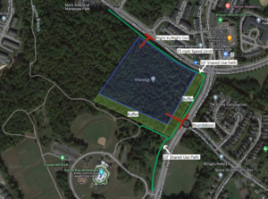
Our key recommendations for the proposed Mayfield Crossing development are summarized above
On August 28, 2023, a rezoning application (Plan Number: REZ2024-00007; Mayfield Crossing) was submitted to Prince William County for a proposed new residential development at the intersection of Manassas Drive and Signal View Drive, just outside the City of Manassas Park. The applicant seeks to rezone a forested 20.56-acre parcel adjacent to Signal Hill Park to develop a residential community with up to 288 dwelling units. On September 5, Active Prince William submitted the following initial feedback on the proposed development:
We have reviewed the Mayfield Crossing Rezoning package [8/28/2023] (corner of Manassas Dr. and Signal View Dr.) posted through the PWC DAPS. While we are disappointed to see this wooded lot adjacent to the Signal Hill Park be developed, we hope you consider the following comments and feedback as this project moves through the rezoning process.
Our concerns are regarding 1) bike/pedestrian infrastructure along Manassas Dr and Signal View Dr (connection to Signal Hill Park), 2) ingress/egress from the new development, and 3) the viewshed from Signal Hill Park/Signal View Dr. Above is a diagram of our recommendations which are explained in detail below:
1. Bike/pedestrian infrastructure along Manassas Dr and Signal View Dr (connection to Signal Hill Park)
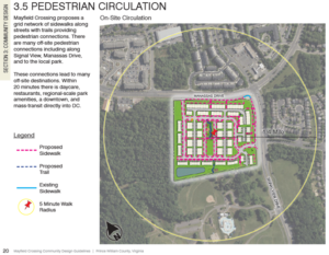
Below is a diagram of the current language for Pedestrian Circulation in the rezoning package. The draft Manassas Park Active Transportation Plan calls for a shared-use path along Manassas Dr and a sidewalk along Signal View Dr next to the development.

The applicant’s proposed Pedestrian Circulation Plan
We recommend the applicant construct:
- A shared-use path along Manassas Dr, from Digital Dr to Signal View Dr.
- A shared-use path along Signal View Dr, from Manassas Dr to the Signal Hill Park Entrance.
Justification: These recommendations complete the trail segments adjacent to the development and the necessary connections to provide a safe connected bike/ped network to nearby destinations. A shared-use path along Signal View Dr is more aesthetically pleasing and matches the existing infrastructure along the roadway. In addition, it reduces the need to cross Signal View Drive in front of Signal Hill Park, which can be a hazard for people walking and bicycling.
2. Ingress/egress from the new development
The current language for ingress/egress in the rezoning package is below:
“The site layout has approximately 950 feet of frontage along Manassas Drive to the north and 800 feet of frontage along Signal Hill Drive. Access to the site is proposed at a full movement entrance along Manassas Drive opposite Christopher Lane and a full movement entrance along Signal View Drive opposite Roseberry Farm Drive.”
The package also indicates right-turn deceleration lanes on Manassas Dr and Signal View Dr. to access the new development
We recommend the applicant construct:
- Right-In/Right-Out access to/egress from the new development on Manassas Dr with no deceleration lane. We also recommended that the City of Manassas Park lower the speed limit on Manassas Dr, from Signal View Dr to Railroad Dr, to 25mph.
- A Single-Lane Roundabout on Signal View Dr at the intersection of Roseberry Farm Dr and the ingress/egress point of the new development.
Justification: As this area continues to urbanize, we must design our transportation network for all users and not on the elements that enable the fast movement of motorized vehicles. A 25-mph speed limit would eliminate the need for a deceleration lane on Manassas Dr, whereas the full-movement unsignalized intersection on Manassas Dr proposed by the applicant would create more conflict points that lead to an increase in vehicle crashes.
A roundabout on Signal View Dr would provide much safer ingress/egress for residents of Roseberry Farms as well as residents of the new development. It would also reduce the speed of vehicles on Signal View Dr and enable an opportunity to create gateway signage to enter Signal Hill Park (Signal Hill Park is on both sides of Signal View Dr.)
3. Viewshed from Signal Hill Park/Signal View Dr
The current illustrations in the rezoning package show limited or no tree buffer along Signal View Dr and along the south side of the development adjacent to Signal Hill Park.
We recommend that the applicant:
- Maintain a 50’-100’ tree buffer along Signal View Dr (similar to Roseberry Farms)
- Maintain a 50’-100’ tree buffer along the south side of the development adjacent to Signal Hill Park
- Bury all utilities along Manassas Dr, from Digital Dr to Signal View Dr
- Bury all utilities along Signal View Dr adjacent to development (prefer if all utilities could be buried in Signal Hill Park)
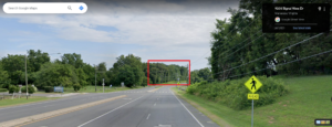
Justification: The viewshed from the Civil War Monument/Entrance to Signal Hill Park along Signal View Dr should be maintained. See picture below.

The current view from Signal View Drive (from Google Maps Street View)
Thank you for considering these recommendations as the Mayfield Crossing Rezoning project moves through the rezoning process.
###
