Advancing active mobility in greater Prince William, Virginia

Category: Prince William County Planning Commission

Our Comments on the Mayfield Crossing Rezoning Application

Our key recommendations for the proposed Mayfield Crossing development are summarized above

On August 28, 2023, a rezoning application (Plan Number: REZ2024-00007; Mayfield Crossing) was submitted to Prince William County for a proposed new residential development at the intersection of Manassas Drive and Signal View Drive, just outside the City of Manassas Park.   The applicant seeks to rezone a forested 20.56-acre parcel adjacent to Signal Hill Park to develop a residential community with up to 288 dwelling units.  On September 5, Active Prince William submitted the following initial feedback on the proposed development:


We have reviewed the Mayfield Crossing Rezoning package [8/28/2023] (corner of Manassas Dr. and Signal View Dr.) posted through the PWC DAPS.  While we are disappointed to see this wooded lot adjacent to the Signal Hill Park be developed, we hope you consider the following comments and feedback as this project moves through the rezoning process.

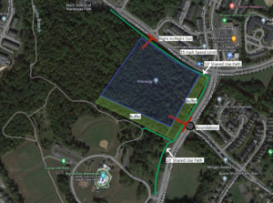
Our concerns are regarding 1) bike/pedestrian infrastructure along Manassas Dr and Signal View Dr (connection to Signal Hill Park), 2) ingress/egress from the new development, and 3) the viewshed from Signal Hill Park/Signal View Dr.  Above is a diagram of our recommendations which are explained in detail below:

1. Bike/pedestrian infrastructure along Manassas Dr and Signal View Dr (connection to Signal Hill Park)

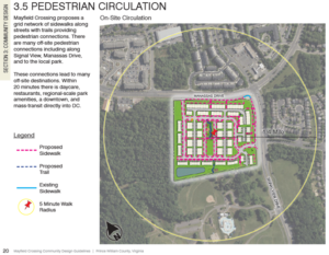
Below is a diagram of the current language for Pedestrian Circulation in the rezoning package.  The draft Manassas Park Active Transportation Plan calls for a shared-use path along Manassas Dr and a sidewalk along Signal View Dr next to the development.

The applicant’s proposed Pedestrian Circulation Plan

We recommend the applicant construct:

  • A shared-use path along Manassas Dr, from Digital Dr to Signal View Dr.
  • A shared-use path along Signal View Dr, from Manassas Dr to the Signal Hill Park Entrance.

Justification: These recommendations complete the trail segments adjacent to the development and the necessary connections to provide a safe connected bike/ped network to nearby destinations.  A shared-use path along Signal View Dr is more aesthetically pleasing and matches the existing infrastructure along the roadway.  In addition, it reduces the need to cross Signal View Drive in front of Signal Hill Park, which can be a hazard for people walking and bicycling.

2. Ingress/egress from the new development

The current language for ingress/egress in the rezoning package is below:

The site layout has approximately 950 feet of frontage along Manassas Drive to the north and 800 feet of frontage along Signal Hill Drive. Access to the site is proposed at a full movement entrance along Manassas Drive opposite Christopher Lane and a full movement entrance along Signal View Drive opposite Roseberry Farm Drive.

The package also indicates right-turn deceleration lanes on Manassas Dr and Signal View Dr. to access the new development

We recommend the applicant construct:

  • Right-In/Right-Out access to/egress from the new development on Manassas Dr with no deceleration lane.  We also recommended that the City of Manassas Park lower the speed limit on Manassas Dr, from Signal View Dr to Railroad Dr, to 25mph.
  • A Single-Lane Roundabout on Signal View Dr at the intersection of Roseberry Farm Dr and the ingress/egress point of the new development.

Justification:  As this area continues to urbanize, we must design our transportation network for all users and not on the elements that enable the fast movement of motorized vehicles.  A 25-mph speed limit would eliminate the need for a deceleration lane on Manassas Dr, whereas the full-movement unsignalized intersection on Manassas Dr proposed by the applicant would create more conflict points that lead to an increase in vehicle crashes.

A roundabout on Signal View Dr would provide much safer ingress/egress for residents of Roseberry Farms as well as residents of the new development.  It would also reduce the speed of vehicles on Signal View Dr and enable an opportunity to create gateway signage to enter Signal Hill Park (Signal Hill Park is on both sides of Signal View Dr.)

3. Viewshed from Signal Hill Park/Signal View Dr

The current illustrations in the rezoning package show limited or no tree buffer along Signal View Dr and along the south side of the development adjacent to Signal Hill Park.

We recommend that the applicant:

  • Maintain a 50’-100’ tree buffer along Signal View Dr (similar to Roseberry Farms)
  • Maintain a 50’-100’ tree buffer along the south side of the development adjacent to Signal Hill Park
  • Bury all utilities along Manassas Dr, from Digital Dr to Signal View Dr
  • Bury all utilities along Signal View Dr adjacent to development (prefer if all utilities could be buried in Signal Hill Park)

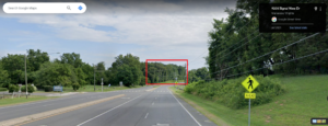
Justification:  The viewshed from the Civil War Monument/Entrance to Signal Hill Park along Signal View Dr should be maintained.  See picture below.

The current view from Signal View Drive (from Google Maps Street View)

Thank you for considering these recommendations as the Mayfield Crossing Rezoning project moves through the rezoning process.

###

Our Recommendations for Upcoming NVTA Transportation Funding Applications from PWC

On July 19, 2021, Active Prince William sent the following email message to the Prince William County Planning Commission, which will soon be briefed by County transportation staff on the transportation projects that the County is considering for submission to the Northern Virginia Transportation Authority (NVTA) in Fall 2021 for  potential regional funding .  Various local transportation and elected officials, including the Prince William Board of County Supervisors, were copied on this message.


Active Prince William supports the integration of land use, housing, and transportation planning.  Having the Transportation Department brief the Commission on planned grant applications is a start.  That step should be followed by a formal public hearing and a vote of the Planning Commission.

New mobility infrastructure should substantially enhance the transit and bike/pedestrian network, rather than simply expand the road network and add a desolate side path.  Traditional “business as usual” planning for the next decade will sabotage the county’s commitment to reduce greenhouse gas emissions by 2030 to 50% of the 2005 levels.  The transportation sector generates the greatest amount of greenhouse gas emissions in Prince William now.  The only way to meet the 2030 target is to reduce the carbon spewing from tailpipes in Prince William, and that requires a new approach to planning for multimodal *mobility* and access, rather than just paving more roads for drive-alone motorists.

In 2030, most cars will still be fueled by gasoline.  Virtually every project that paves more lane miles will increase Vehicle Miles Traveled (VMT) and greenhouse gas emissions from those cars.  To understand the impact of various proposed projects, the Planning Commission should identify the projected increase in VMT associated with each transportation project, and use that data when determining which projects to recommend to the BOCS.

The Planning Commission recommendations to the BOCS should be guided by the Strategic Plan.  The Strategic Plan calls for the County to develop in a sustainable way.  As you know, new transit and bike/pedestrian projects have the potential to reduce or minimize VMT and associated greenhouse gas emissions.  To be sustainable, the County must abandon the old school approach of just building more roads–and acknowledge that more roads have not reduced traffic congestion.

For the upcoming NVTA grant program, Active Prince William recommends submitting the following projects to the next NVTA funding round (FY26/FY27). As you can see, none of these projects’ main intent is to add lane miles.  All projects support Transit, Active Transportation, and/or Intersection/Interchange improvements.

  • Route 1/Potomac Mills BRT (TRANSIT) – NVTA 38/39
  • Dale Blvd Improvements (TRANSIT) – NVTA 241
  • VRE Second platforms – Manassas Line (TRANSIT) – NVTA 300
  • I-95 Ped/Bike Crossings (TRAILS/ACTIVE TRANSPORTATION) – NVTA 300/242/49/241
  • Balls Ford Road/I-66 Trail Improvements (TRAILS/ACTIVE TRANSPORTATION)  – NVTA 50
  • Route 123 Improvements (INTERCHANGE/INTERSECTION IMPROVEMENT) – NVTA 242
  • Wellington Rd/Sudley Manor/VA234 Interchange Improvements (INTERCHANGE/INTERSECTION IMPROVEMENT) – NVTA 222
  • Minnieville Rd/PW Parkway Interchange (INTERCHANGE/INTERSECTION IMPROVEMENT) – NVTA 279
  • Pageland Ln/Sanders Ln Safety Improvements (INTERCHANGE/INTERSECTION IMPROVEMENT) – NVTA 227
  • Route 28 STARS (INTERCHANGE/INTERSECTION IMPROVEMENT) – NVTA 29/32

Many of these projects do not match exactly with the NVTA Transaction description but the NVTA has set a precedent by funding innovative intersection improvements at University Boulevard and Prince William Parkway even though NVTA Transaction clearly requires “Construct Interchange at Prince William Parkway and University Boulevard.” (NVTA 324).  Active Prince William agrees with this approach as the intent of the projects is to improve the specified transportation segment.

Below is the list of projects that were not funded in the previous NVTA funding round (FY24-FY25).   As you can, see most of these projects’ main intent is to add lane miles that will induce new VMT and future congestion.  We need to stop advancing projects that continue to increase car dependency and have long-term adverse impacts on the climate and county budget.

  • Van Buren Road North Extension: Route 234 to Cardinal Drive (NEW ROADWAY)
  • Construct Route 28 Corridor Roadway Improvements (NEW ROADWAY/BYPASS)
  • University Boulevard Extension: Devlin Road to Wellington Road (NEW ROADWAY)
  • Wellington Road Widening: University Boulevard to Devlin Road (ROAD WIDENING)
  • Devlin Road Widening: Linton Hall Road to Relocated Balls Ford Road (ROAD WIDENING)
  • Route 234 and Sudley Manor Drive Interchange (INTERCHANGE/INTERSECTION IMPROVEMENT)
  • Prince William Parkway at Clover Hill Road Innovative Intersection (INTERCHANGE/INTERSECTION IMPROVEMENT)
  • Prince William Parkway at Old Bridge Road Intersection Improvements (INTERCHANGE/INTERSECTION IMPROVEMENT) | Funded via Smart Scale

###