Active Prince William’s Proposal for ‘Well Street Extended’ (aka ‘Revitalize Yorkshire’), a ‘Modified Alternative 4’ for the Route 28 Corridor Improvements in Yorkshire (Manassas Drive to Compton Road in Fairfax County)
(Originally posted on September 7, 2020)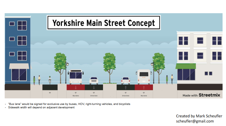
Active Prince William and five other smart growth and environmental groups sent the following joint letter to the Prince William Board of County Supervisors on September 4, 2020 in which we outlined our proposal to amend the Prince William County Comprehensive Plan (Comprehensive Plan Amendment or CPA) to pursue Route 28 Corridor ‘Alternative 4’ (widening Centreville Road from Manassas Drive to Compton Road) to explicitly consider our recommendation for a ‘Modified Alternative 4‘, which we are calling ‘Well Street Extended‘.
The text of our joint letter follows:
Dear Board of County Supervisors:
We support the Board’s August 4 decision to pursue Alternative 4 for the Route 28 corridor, and recommend the County use a two-phased approach going forward:
Phase One would develop an eight-lane multimodal concept for the northern portion of the corridor (Orchard Bridge Drive to Compton Road, including the Bull Run Crossing), to quickly access the $89 million previously allocated by the Northern Virginia Transportation Authority (NVTA).
Phase Two would thoughtfully pursue the integration of economic development and land use planning opportunities with planning for new multimodal transportation capacity along the southern portion of the corridor between Manassas Drive and Orchard Bridge Drive.
More details are below:
We support your August 4, 2020 decision to adopt Alternative 4 from the Route 28 Corridor Study.
A Comprehensive Plan Amendment (CPA) is now required to revise outdated language, such as that referenced in Table 2 –Thoroughfare Plan Summary in the Transportation Chapter of the Comprehensive Plan (“PW-3 Tri-County Parkway/Route 28 Bypass”).
The benefits of such a considerable investment in transportation infrastructure should not be limited to efforts moving drive-alone commuters faster to jobs outside the County. In the initiation of the CPA to advance Alternative 4, we encourage you to articulate your goals for concurrently planning for economic development, land use, affordable access to jobs and housing, and cleaner, multimodal transportation improvements.
The CPA should:
1) require assessing how investment in Route 28 mobility can be leveraged to spur economic revitalization; and
2) clarify that the “purpose and need” of Route 28 improvements is to increase local multimodal mobility, create a more walkable and transit-oriented corridor, reduce pollution, and facilitate the creation of local jobs and equitable access to them.
To more quickly access some funding previously allocated to the Route 28 corridor project by the Northern Virginia Transportation Authority (NVTA) [$89 million, total], we suggest the CPA divide Alternative 4 into two phases:
• Phase One — Focus on widening the Route 28 bridge across Bull Run, adding bike/pedestrian and future transit capacity as part of the widening, and smoothing traffic flow north to Compton Road. That capacity expansion should qualify for use of the NVTA funding allocation.
• Phase Two –- Focus more broadly to include consideration of additional vehicle and bus/HOV lanes on existing Route 28 or the Well Street Extended corridor, to stimulate development of a walkable and transit-oriented corridor in the Yorkshire area and to move more people within and through the corridor.
Phase Two would be the time frame in which to combine detailed, localized land use planning and placemaking for Yorkshire, together with changes in transportation infrastructure. These functions warrant further analysis.
The Route 28 Corridor Study prioritized the analysis of Alignment 2B only. Alternative 4 was not given sufficient focus and detail during the two years after completion of the prior Feasibility Study.
The CPA process should ensure consideration of an approach to “widening” the Route 28 corridor by building new lanes using the Well Street Extended corridor, approximately 400 feet west of existing Route 28, similar to the Mathis Ave alignment in the City of Manassas.
New capacity in the corridor, paired with the STARS Study recommended improvements on the existing four lanes of Route 28, may adequately reduce traffic congestion as well as enhance economic and community development and retention of existing businesses. There are more beneficial ways to upgrade mobility, besides the approach used to widen Route 1 which required extensive business displacements.
“Mobility” means more than “move cars.” The CPA should require evaluating opportunities for enhanced walkability and bus transit to maximize movement while sustainably reducing congestion and travel times.
Though Yorkshire today lacks even OmniRide service, transit on Route 28 is not a new idea. Since 2008, the Comprehensive Plan has proposed building light rail from Manassas to Dulles.
The NVTA TransAction plan, approved in 2017, also includes a Route 28 High Capacity Transit project to “Construct High Capacity Transit along Route 28 corridor and implement service between Dulles Town Center and the City of Manassas. Alternative modes for further study include BRT and LRT.”
Prince William County must continue to plan smarter, to ensure that high-cost transportation upgrades concurrently spur local jobs and create more walkable places with reduced per capita driving.
We appreciate your thoughtfulness in evaluating the wide range of concerns before rejecting Alignment 2B. We look forward to the Flat Branch stream valley now becoming a linear park with trails connecting the adjacent neighborhoods and for Yorkshire planning to demonstrate how transportation improvements can be coordinated with land use, economic development, placemaking, and the creation of affordable housing.
Revitalizing the Yorkshire area will promote social, cultural, and environmental sustainability and neighborhood economic resiliency, while providing new job opportunities, maintaining the sense of community, and offering affordable housing. This is the direction of smart growth planning needed.
Placemaking collectively re-imagines and revitalizes public spaces in a community. Community participation in developing the Yorkshire revitalization plan is imperative in order to capitalize on the community’s assets, inspiration, and potential, thereby resulting in the creation of a quality public space that contributes to equity, health and well-being.
Sincerely,
###
The Route 28 Manassas Bypass Is Not the Lowest Cost Or the Least Environmentally Damaging Practicable Alternative (LEDPA) for the Route 28 Corridor (Originally posted on December 1, 2020)
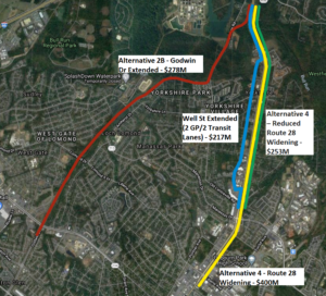
The Alignments of the Four Route 28 Corridor Expansion Alternatives Compared Below
Active Prince William board member Mark Scheufler sent the following comparison of Route 28 corridor alternatives to the Prince William Board of County Supervisors on November 30, 2020.
Dear Prince William Board of County Supervisors:
In advance of the December 7th virtual public meeting on Route 28, it is timely to correct misinformation about the alternatives to Alignment 2B. The costs of Alternative 4 (Widening Route 28) were overstated by calculating the impacts/costs of widening Route 28 between Blooms Quarry Lane and Liberia Ave that is already six lanes.
Realistic cost estimates are needed not only by the supervisors in Prince William and Fairfax counties, but also by the US Army Corps of Engineers and the Virginia Department of Environmental Quality. Those two agencies may determine that cost differences between Alignment 2B and other alternatives are not sufficient to justify the greater environmental damage.
As the Meeting Minutes at the January 16, 2020 Project Update and Alternatives Development Technical Memo Review state (on pages 2 and 3):
“Stuart ended with a presentation of the cost summary for the alternatives, which showed that Alternative 4 would be almost $100 million more than Alternatives 2A and 2B. MacKenzie indicated that cost would not be a factor that the Department of Environmental Quality (DEQ) would consider in their evaluation. Rick responded that he understood, but emphasized the need to consider purpose and need in the comparison of the alternatives.
Subsequent to the meeting, Hannah Schul, DEQ, clarified that DEQ makes permitting decisions based on the Least Environmentally Damaging Practicable Alternative (LEDPA). Per the Clean Water Act, a permit cannot be issued if a practicable alternative exists that would have less adverse impacts on the aquatic ecosystem. The LEDPA does take cost into consideration, but an alternative would only be potentially eliminated if costs are clearly exorbitant compared to similar alternatives.”
The analysis summarized in the table below [the complete ROW analysis is here] shows the cost of alternatives along or near existing Route 28 are not exorbitant compared to Alternative 2B. Alternative 4 includes $37M in ROW impacts along a 1.1-mile section of Route 28 that is already six lanes and should require minimal improvement and no ROW impacts (Blooms Quarry Lane to Liberia Ave). An additional $54M* in Alternative 4 ROW impacts could be mitigated by increasing the Utility Relocation Costs ($10M). These modifications would bring the Alternative 4 cost estimate below Alternative 2B. But implementing the Route 28 STARS recommendation and the Well St Extended recommendation is the best alternative for the Route 28 corridor to meet transit, revitalization, and climate goals and is the cheapest alternative. The Well St Extended recommendation was not included in the original set of alternatives because transit, revitalization and climate were not considered part of the project purpose and need.
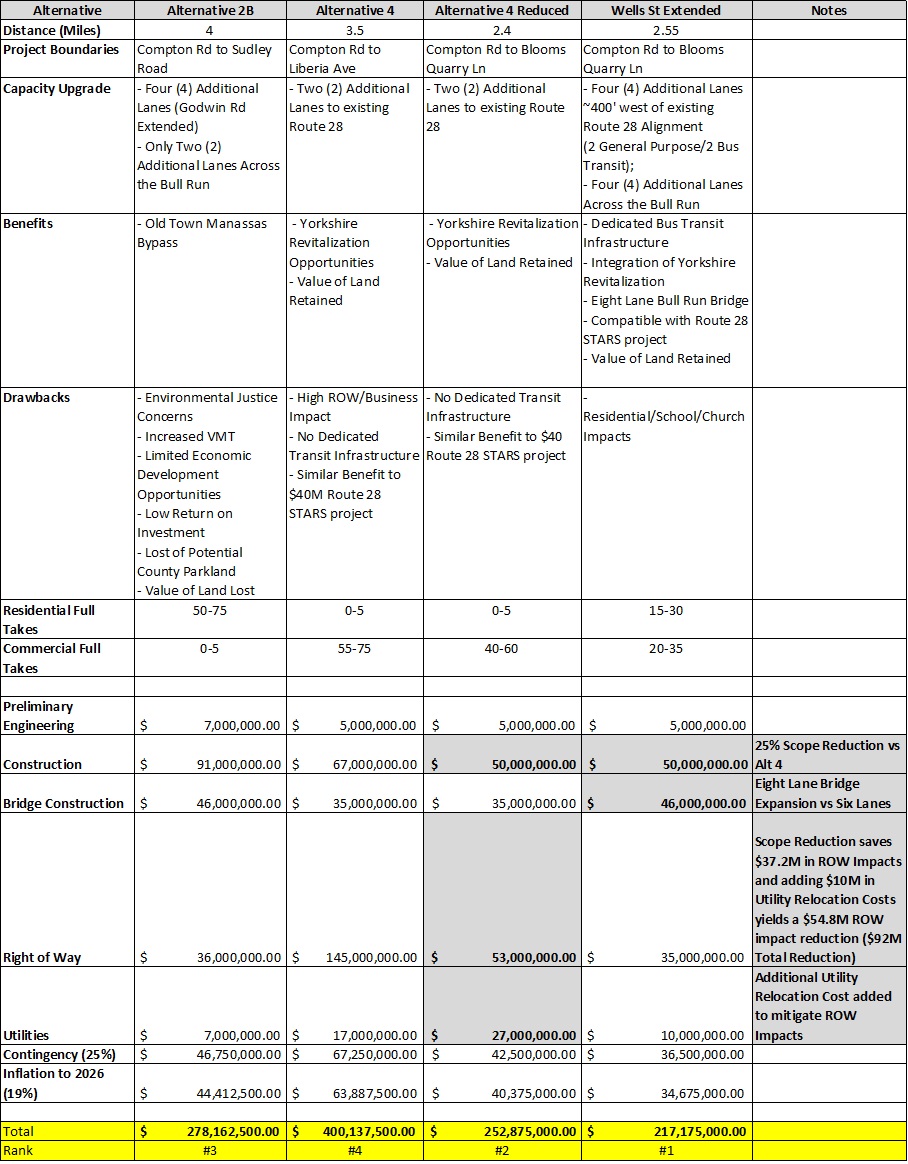
A Comparison of Four Route 28 Corridor Alternatives (click on the image above to enlarge for reading)
Alternative 2B is not the Least Environmentally Damaging Practicable Alternative (LEDPA) and may not receive permits to move forward. Creating a regional park along this alignment is the best use of the land in the flood plan.
*8300 CENTREVILLE RD, 8130 OAK ST, 7901 CENTREVILLE RD
If you need any clarification, please let me know.
Thanks,
Mark Scheufler
PWC Resident
###