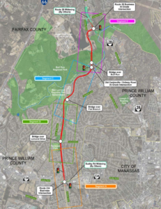
On April 19 and 20, 2023, the Prince William County Department of Transportation held a pair of public information meetings to present the status of its Route 28 Bypass project at roughly the 30% design stage. In response to the information presented, Active Prince William submitted the following written comments on May 3, 2023.
Related Update: On May 23, 2023, the Prince William County Trails and Blueways Council unanimously adopted this resolution that also calls for better shared-use path connections in the Route 28 Bypass project.
Please consider these comments on the Route 28 Bypass, based on information that was presented at the April 19 and 20 Route 28 Bypass Project Public Information Meetings:
Traffic and Environmental Studies, Sustainability, and Cost Comments
The ongoing traffic forecast and environmental studies for the Bypass should report relevant data that will help the public, the Prince William Board of County Supervisors, environmental oversight agencies, and other stakeholders determine whether building this highway project would be a prudent investment for both our region and for Prince William County taxpayers.
1. Please report the additional Vehicle Miles Traveled (VMT) and Greenhouse Gas (GHG) emissions this project would generate vs. the no-build alternative.
Justification: The information will help the PWC BOCS make an informed decision about the project as it weighs competing priorities about the environment and sustainability, including consistency with Visualize 2050’s policies and the objectives of the County’s own Community Energy and Sustainability Master Plan.
2. Please report the additional noise and air pollution this project would generate within ½ mile of the corridor vs. the no-build alternative.
Justification: Understanding the full impacts on nearby property owners within an Equity Emphasis Area that would lack direct access to the roadway facility is paramount for PWC BOCS to make strategic future decisions about this project vs. other priorities.
3. Please report the residency locations of the projected Route 28 Bypass users; in particular, what percentage of projected highway users would reside in a) Prince William County, b) the City of Manassas, c) localities west or south of Prince William County, and d) localities north or east of Prince William County?
Justification: With 90%+ of the cost of the project being funded by PWC taxpayers via NVTA and the 2019 Mobility Bond, this is useful information to help the PWC BOCS make strategic future decisions about this project vs. other priorities.
4. Please report an updated project cost estimate based on the 30% design.
Justification: With highway construction costs increasing by 50% in the past two years, it is difficult for stakeholders to understand the viability of a 2019 $300M cost estimate as the PWC BOCS plans to invest significant taxpayer $$$ into the project soon.
* * *
Shared Use Path/Trail Comments
If located in most other suburban communities, the Flat Branch stream valley would have been developed–decades ago–as a linear regional park, with non-motorized access serving and unifying the communities on either side. Because the County has long reserved this corridor for a potential future freeway, the development of such a stream valley park has been delayed for decades. Construction of the Bypass would establish a permanent man-made physical highway barrier between the equity-emphasis-area communities on each side. In the interests of environmental justice and sustainable transportation, it is essential that the Bypass include a robust network of paved (and natural-surface) trails for transportation and recreation, both along and across the stream valley.
* * *
5. Please consider relocating the adjoining shared-use path–along the Bypass segment between Sudley Rd and the Bypass bridge over Flat Branch–to follow the west side of the Bypass, to facilitate access from the Fairmont, West Gate, and Sudley communities.
In addition, build local asphalt shared-path connections between the relocated shared-use path along the west side of the Bypass to the Fairmont, West Gate, and Sudley neighborhoods from at least these five locations:
- Fairmont Ave in the vicinity of the Flat Branch tributary or the east end of Heritage Crossing Ct,
- Fairmont Ave via the southern portion of Fairmont Park, somewhere between Rickover Ct and Portsmouth Rd,
- both sides of Lomond Dr,
- the east end of Dublin Dr, and
- the north end of King George Dr.
Also, please ensure that all shared-use paths are generally designed to be as flat/level as the Bypass roadway, except where needed to achieve grade-separated roadway or stream crossings. Provide physical barriers between the shared-use path and the roadway–such as non-mountable concrete curbs and/or jersey barriers–especially wherever the grass buffer between the shared-use path and the roadway would be less than eight feet wide
Justifications: The Flat Branch stream would limit and complicate access to any shared-use path along the east side of the Bypass from the neighborhoods in Loch Lomond; any shared-use along the Bypass requires frequently spaced connections to nearby neighborhoods for reasonable access by foot or bicycle; and any shared-use path near the Bypass must provide a physical barrier from roadway departures by high-speed motor vehicles.
* * *
6. Please consider developing and improving the existing UOSA access road to the east of the Bypass as a second, better separated shared-use path , with trail bridge connections across Flat Branch and its tributaries to serve the Loch Lomond neighborhood between Sudley Rd and Splashdown Waterpark. This shared-use path should be extended beyond the current northern end of the UOSA access road, to parallel the remainder of the Bypass to its northern terminus along its east side. Trails along UOSA easements are common in Fairfax County.
In addition, provide access to the UOSA access road/future shared-use path along the east side of the Bypass from the Loch Lomond neighborhood via asphalt shared-use paths (with ped/bike trail bridges across Flat Branch and/or its tributaries where necessary) from at least these eight locations:
- Sunset Dr in the vicinity of the west end of Highland St,
- both sides of Lomond Dr, going under the highway overpass used by the Bypass,
- near the north end of Lomond Dr between Victoria St and Manassas Dr,
- Amherst Dr along the existing earthen berm that lies midway between Appomattox Ave and Alleghany Rd,
- the north end of the Alleghany Rd/Albemarle Dr junction,
- in the vicinity of Boundary Dr,
- in the vicinity of Jacobs Ln, and
- where Old Centreville Rd will connect to the Bypass.
Use trail underpasses in stream box culverts, the Bypass bridge over Flat Branch, or along both sides of Lomond Dr to connect the shared-use path along the current UOSA access road to the relocated shared-use path along the west side of the Bypass and from there to the Fairmont, West Gate, and Sudley communities.
Justification: The area along Flat Branch should be developed into a linear park for enjoyment by the surrounding communities that would lack direct access to the new roadway. By providing shared-use paths along both sides of the Bypass, the shared-use path connections under the Bypass would become much more effective in linking the low- and moderate-income, majority-minority communities that the Bypass would otherwise permanently sever
* * *
7. Please design a shared-use path /trail connection under the Bypass bridge that crosses over Flat Branch.
Justification: This connection would provide non-motorized access between communities on the east and west of the Bypass and provide communities on the east side of the Bypass with access to Splashdown Waterpark, thus reducing vehicle trips along neighborhood streets. Moreover, north of the Bypass bridge over Flat Branch, only one shared-use path would be provided along the Bypass, on its east side, and the UOSA access road ends south of that crossing . In other words, this trail connection would extend any adjacent shared-use path that begins on the west side of the Bypass at Sudley Rd though the remainder of the Bypass route.
* * *
8. Please consider leaving all or part of the existing Old Centreville Rd Bridge over Bull Run in place as the Ped/Bike connection over the waterway.
Justification: This reduces the cost to the project and is a much more pleasant access point and amenity to the surrounding community than walking or biking next to a 45-mph roadway
* * *
9. Please consider including as part of the project planting hundreds/thousands of canopy trees to absorb and filter stormwater, reduce highway noise in the adjoining neighborhoods, and provide much-needed shade for trail users in warm and hot weather. The trail(s) should also include user amenities such as trail lighting, benches, and trash receptacles.
Justification: This project clearly bisects Equity Emphasis Areas while simultaneously not providing them access to the roadway. It is imperative to add trail, park, and flood control amenities with the project to support the surrounding community.
* * *
Roadway Comments
10. Please consider implementing a Continuous Green-T intersection at Route 28 Bypass/Old Centreville intersection.
Justification: This allows for a non-stop southbound trip between existing Route 28 and Sudley Rd.
11. Please consider providing some form of [emergency or uncontrolled] left turn capacity from Northbound Route 28 Bypass to Ordway Rd.
Justification: During incidents in or around the Route 28/Compton Rd intersection, this capacity would provide a relief valve to clear traffic congestion more quickly
12. Please consider adding a left turn from Route 28 Northbound to Route 28 Bypass Southbound (with access to Ordway Rd) and removing both left turns from Route 28 Compton Rd intersection.
Justification: This creates a third light phase to the Route 28 Bypass/Route 28 intersection and reduces the Compton Rd/Route 28 intersection to three light phases. Access via Ordway Rd provides the route to Compton Rd. This will improve synchronization between the two adjacent light signals (Route 28/Route 28 Bypass & Route 28/Compton Rd).
* * *
Thank you for soliciting public comments at this early stage of project design. We would be happy to meet with members of the project team to discuss these comments in more detail.
Sincerely,
Mark and Allen
Mark Scheufler & Allen Muchnick, Co-Chairs
Active Prince William
Advancing active mobility for a more livable, equitable, & sustainable greater Prince William, Virginia
Email: Active.PrinceWilliam@gmail.com
Website: www.activepw.org
Facebook: https://www.facebook.com/ActivePW
Twitter: @Active_PW https://twitter.com/Active_PW
###

The speed limit on RT. 28 in Yorkshire is
45 mph. With Stores , apartment s, and homes, there are few sidewalks or crosswalks. There is no island between the 4 lanes and car’s wizzing by at 50 mph . Pedestrians risk their lives crossing or walking to shop or do anything pon rt. 28 . Up the road in Manassas City there are sidewalks and a speed limit of 25 mph .anll adults and children pedestrians to shop ,etc, without risking their lives. If 28 isn’t being fixed , at least lower speed limit. The bypass is Proceeding and other newer developments in PWC is continuing west and east of Yorkshire.
Our blue collar community has the speed limit of a rural road without shops, homes, schools, and nonstop traffic. I have picture of a young couple dodging traffic from the middle turn lane with a baby stroller on Sunday. Too scary!
Both Fairfax and Arlington County recently lowed speed limit in areas to make their communities safer . Please make our community safer.