Advancing active mobility in greater Prince William, Virginia

Category: Planning (Page 1 of 7)

Our Comments on PWC’s Proposed Route 1 Widening

A bus priority lane on University Boulevard in Montgomery County, MD

On January 16, 2025, Active Prince William sent the following comments to the Prince William Board of County Supervisors (BOCS) in response to a new funding request by County staff to initiate the widening of a new segment of U.S. Route 1 (between Cardinal Dr and Dumfries Rd), to create a high-speed arterial roadway with six through travel lanes for personal motor vehicles.

PWC BOCS,

After reviewing Agenda Item 8A on the 1/21/25 PWC BOCS Agenda, we are disappointed there was no public announcement and input opportunity for these priorities/plans before the agenda’s release.

While we  acknowledge that the Route 123/Old Bridge Rd flyover, Sudley Manor Dr/Route 234 Interchange, and Clover Hill Rd/Route 234 Intersection are active projects, we are disappointed that the Route 1 widening project is part of this agenda item.

This Route 1 corridor segment, which includes the highest ridership Omniride local route (53 | Dumfries Connector), provides an opportunity to scope a major transit project by adding bus lanes or business access and transit (BAT) lanes.

Route 1 should be designed as a walkable and livable mixed-use regional activity center, not as a mini I-95. The county should reject the long-discredited mindset that widening commercial roadways is a viable long-term strategy that improves resident quality of life.

Such widening projects induce an even-higher vehicle mode share, burden families with increased vehicle ownership costs, render active mobility unsafe and miserable, and generate negative environmental externalities, such as noise, air, and water pollution.  This project would depress transit ridership in favor of increased vehicle speeds, reduced safety, and more traffic congestion for future generations. These outcomes are in direct conflict with many proposed strategic plan goal elements.

While PWC transportation staff is proposing widening Route 1 this week, Arlington County and VDOT are recommending removing interchanges from their section of Route 1 and lowering the speed limit to 25 MPH, to reconnect the community as part of major economic development initiative, while Fairfax County and VDOT are advancing a major Bus Rapid Transit initiative along Route 1.

Prince William County is no longer a rural/exurban county with 200,000 people like Stafford County; it’s an increasingly urban county of almost 500,000 people that must significantly diversify its transportation mode share to improve quality of life for its residents.

We need to prioritize affordable housing AND affordable transportation.

We recommend the PWC BOCS:

  • Gather resident input on more sustainable alternatives for this Route 1 segment
  • Initiate a Citizen Transportation Advisory Commission, to vet transportation project priorities in a public forum before they reach the BOCS agenda
  • Prioritize projects that reduce Vehicle Miles Traveled

Thank you for considering this feedback.

Mark Scheufler & Allen Muchnick, Co-Chairs
Active Prince William
Advancing active mobility for a more livable, equitable, & sustainable greater Prince William, Virginia
Twitter: @Active_PW https://twitter.com/Active_PW

Fund a Strategic Countywide Active Mobility Plan Plus $10 Million in Pedestrian, Bicycle, & Trail Improvements in the FY 2025 County Budget

On January 9, 2024, Active Prince William sent the following message to the Prince William Board of County Supervisors (PW BOCS) to request funding for two items in the FY 2025 County Budget: $3 million to develop a strategic active mobility plan for Prince William County and $10 million to implement active mobility and trail improvements.


Please consider funding the following items in the Prince William County FY 2025 Budget to support elements approved in the Community Energy and Sustainability Master Plan (CESMP).  Strong support was received from BOCS members for two of our recent BOCS candidates’ survey questions about 1) funding an Active Mobility Plan and 2) completing PWC’s planned National Capital Trail Network (NCTN) segments by 2030.

1. Active Mobility Plan  | $3 Million, one-time FY2025 funding line item

Justification: The Active Mobility Plan must be developed to provide a strategic/prioritized effort to enable bike/pedestrian projects identified in the 2040 Mobility Chapter to become projects in the Capital Improvement Program (CIP) budget.

The Active Mobility Plan–for transportation and recreation–must assess the existing pedestrian and bicycle networks within Prince William County and identify gaps to fill that will produce the greatest improvements in overall connectivity. This should include elements such as Complete Streets; Safe Route to Schools, Parks, and other community destinations; and Vision Zero policies and programs; regionally significant trails (NCTN, PHNST, ECG, US Bike Route 1, and the I-66 Parallel Trail); crossings of I-95, I-66, the Bull Run and Occoquan Rivers, and other barriers (highways and railroads); an active roadway reconfiguration program; plus various types of purely recreational trail projects and park sites and identifying the staff capacity to plan, construct, promote, operate, maintain, and rehabilitate all the elements not managed by VDOT.  The plan must also ensure that the County’s future active transportation networks mesh with neighboring networks planned for the City of Manassas, City of Manassas Park, Stafford County, and Fairfax County, in order to create the highest overall level of connectivity region-wide.

We recommend that the county hire an experienced outside consultant team to coordinate the development of this plan and to incorporate a robust public involvement component (e.g., a set of at least two public input opportunities, the involvement of agency staff and citizen work groups [including the existing Trails and Blueways Council], and targeted outreach to low-income, ethnic minority, and immigrant communities.  This would be analogous to how the County developed the CESMP and is planning to implement the SS4A Action Plan grant.

2. Mobility and Recreation Trails (General Fund) | $10 Million (Recommended to be an ongoing budget line item) 

Justification: Sustained General Fund money for trail infrastructure is needed to advance projects through the planning, engineering, right of way, and construction stages.  With over 200 miles of identified missing sidewalks and planned shared-use paths, this sustained funding level is needed to implement the Active Mobility Plan and leverage non-general fund dollars (e.g., TRIP and other developer contributions, VDOT revenue sharing, TAP, HSIP, CMAQ/RSTP, NVTA, USDOT grants, and concurrent highway construction, etc.)

Thank you for considering these requests.

Mark Scheufler & Allen Muchnick, Co-Chairs
Active Prince William
Advancing active mobility for a more livable, equitable, & sustainable greater Prince William, Virginia
Twitter: @Active_PW https://twitter.com/Active_PW

Our Comments for the National Capital Trail Network Update in Greater Prince William

October 2023 draft update of the National Capital Trail Network in greater Prince William.  The green lines are supposed to depict existing trail segments, whereas the purple lines are supposed to depict “planned” trail segments.

The National Capital Trail Network (NCTN) is a 1,400-mile, continuous network of long-distance, off-street trails, serving the entire [metropolitan Washington] region and consisting of both existing and planned segments.  The network was approved by the National Capital Region Transportation Planning Board (TPB) in July 2020 and endorsed by the Metropolitan Washington Council of Governments Board of Directors in August 2020.

As described by TPB staff:  The National Capital Trail Network is intended to be a network of long-distance, off-street facilities. It will be accessible for people of all ages and abilities, designed for non-motorized use, and suitable for both transportation and recreation.  Off-street path width minimums are 10 feet for new construction, 8 feet for existing paths. Paths must be paved or firm surface. On-street facilities must be protected from moving traffic (i.e. parked cars, curbs, or flexposts). All facilities must be directly connected to the network. Short on-street connections on low-volume, low speed streets are permitted to maintain network continuity. Facilities can be existing or planned, but they must be in an approved agency plan.

In June 2022, the TPB adopted a resolution (R18-2022) that called for completing the TPB’s National Capital Trail Network by 2030, as one of seven priority strategies for reducing greenhouse gas emissions from surface transportation in the Washington region.

For at least several months, the TPB staff have sought to engage the region’s localities to submit updates and corrections to the NCTN mapThe main purpose of this update is to measure progress, in miles built, toward the completion of the National Capital Trail Network since its adoption in 2020. Other purposes include adjusting routes where the existing route has proven infeasible or undesirable, addition of new routes where a new plan or new development justifies it, and correction of errors or omissions in the network [emphasis added].

To facilitate this update, Active Prince William submitted the comments below on October 30, 2023.


Comments on the Draft Update to the National Capital Trail Network Map for Prince William County and the City of Manassas
by Allen Muchnick, Co-Chair Active Prince William

1) Nonexistent/”Planned” Trail Segments Erroneously Labeled As “Existing”:  The following segments on the NCTN map should be relabeled as “planned” because they do not currently exist.

  • Nokesville Rd/Rte 28 between the Fauquier County Line and Fitzwater Dr in Nokesville. The segment of Rte 28 west of Fitzwater Dr in Nokesville has not been widened.  It’s still a two-lane road without any bicycle or pedestrian facilities.
  • Minnieville Rd, between Old Bridge Rd and Dumfries Rd, is depicted as having an existing shared use path along it except for the segment (TIP_ID BP11611) between Fowke Ln and Cardinal Drive. However, the NCTN update map erroneously shows this planned segment with a southwest terminus at Smoketown Rd, rather than at Cardinal Dr.  The segment of Minnieville Rd that currently lacks any bicycle facilities is much longer than shown on the NCTN update map.

2) NCTN Segments Currently Labeled As Planned That Have Recently Been Completed:  The following NCTN segments should now be relabeled as “existing”.

  • Nokesville Rd/Rte 28 Shared-Use Path, between Godwin Dr and the PWC Line, in the City of Manassas (TIP_ID 11606).
  • Godwin Dr Shared-Use Path (south), between Wellington Rd and the Winters Branch Trail, in the City of Manassas (TIP_ID BP11604). Note: TIP_ID BP7624 appears to be a duplicate path, possibly on the PWC side of Godwin Dr, which is probably not actually planned and, if so, should be deleted from the map.
  • US-1 Shared-Use Path in North Woodbridge (southern segment of TIP_ID BP7634): The segment between Annapolis Way and Gordon Blvd is complete.
  • Blackburn Rd Shared-Use Path near Neabsco Creek (the bulk of TIP_ID BP7641): The segment between Rippon Blvd and Good Shepherd Lutheran Church is complete.
  • Wellington Rd Shared-Use Path (the western end of TIP_ID 7632): The segment between Linton Hall Rd and University Blvd near Gainesville/Virginia Gateway is complete.
  • VA 234/Dumfries Rd Shared-Use Path (TIP_ID BP7639): This former gap segment between Country Club Dr and Exeter Dr near Montclair is complete.

3) Planned NCTN Segments Depicted On An Erroneous Alignment:

4) Planned NCTN Segments That Should Be Updated: 

  • Manassas Dr east of Signal View Dr in Manassas Park (TIP-ID BP7643): The new Manassas Park Active Transportation Plan identifies an even larger segment of eastern Manassas Dr (between Railroad Dr and Blooms Park) as a candidate for bicycle lanes implemented with a road diet (Project B-10). The NCTN map currently labels the segment of Manassas Dr east of Signal View Dr as planned for a shared-use path.

5) Nationally Significant Long-Distance Trails That Should Be Added to the NCTN Map As “Planned NCTN Segments”:

  • US Bicycle Route 1: At present, a considerable portion of US Bicycle Route 1 through Prince William County is quite hostile to bicycling, even by experienced cyclists.  However, the segments of this route along Fleetwood Dr (Fauquier County Line to Aden Rd), Aden Rd (Fleetwood Dr to Bristow Rd), Bristow Rd (Aden Rd to Independent Hill Dr), Independent Hill Rd (Bristow Rd to Route 234), all of Hoadly Rd, Minnieville Rd (the segment missing a shared-use path from Prince William Pkwy to Fowke Ln), and Old Bridge Rd (Minnieville Rd to Tanyard Hill Rd) are all identified for future shared-use paths in Prince William County’s December 2022 Comprehensive Plan and therefore should be depicted as Planned NCTN segments on the updated NCTN map.
  • East Coast Greenway and Potomac Heritage National Scenic Trail: Except to depict existing or planned sidepaths along Route 1, the current NCTN map does not depict most of the planned ultimate route(s) for the East Coast Greenway and the paved, shared-use segments of the Potomac Heritage National Scenic Trail through Prince William County.  The updated NCTN map should depict those planned routes.

###

Our Comments on the Mayfield Crossing Rezoning Application

Our key recommendations for the proposed Mayfield Crossing development are summarized above

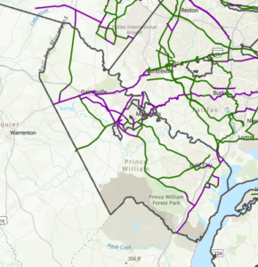
On August 28, 2023, a rezoning application (Plan Number: REZ2024-00007; Mayfield Crossing) was submitted to Prince William County for a proposed new residential development at the intersection of Manassas Drive and Signal View Drive, just outside the City of Manassas Park.   The applicant seeks to rezone a forested 20.56-acre parcel adjacent to Signal Hill Park to develop a residential community with up to 288 dwelling units.  On September 5, Active Prince William submitted the following initial feedback on the proposed development:


We have reviewed the Mayfield Crossing Rezoning package [8/28/2023] (corner of Manassas Dr. and Signal View Dr.) posted through the PWC DAPS.  While we are disappointed to see this wooded lot adjacent to the Signal Hill Park be developed, we hope you consider the following comments and feedback as this project moves through the rezoning process.

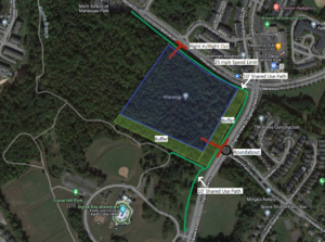
Our concerns are regarding 1) bike/pedestrian infrastructure along Manassas Dr and Signal View Dr (connection to Signal Hill Park), 2) ingress/egress from the new development, and 3) the viewshed from Signal Hill Park/Signal View Dr.  Above is a diagram of our recommendations which are explained in detail below:

1. Bike/pedestrian infrastructure along Manassas Dr and Signal View Dr (connection to Signal Hill Park)

Below is a diagram of the current language for Pedestrian Circulation in the rezoning package.  The draft Manassas Park Active Transportation Plan calls for a shared-use path along Manassas Dr and a sidewalk along Signal View Dr next to the development.

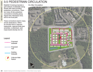
The applicant’s proposed Pedestrian Circulation Plan

We recommend the applicant construct:

  • A shared-use path along Manassas Dr, from Digital Dr to Signal View Dr.
  • A shared-use path along Signal View Dr, from Manassas Dr to the Signal Hill Park Entrance.

Justification: These recommendations complete the trail segments adjacent to the development and the necessary connections to provide a safe connected bike/ped network to nearby destinations.  A shared-use path along Signal View Dr is more aesthetically pleasing and matches the existing infrastructure along the roadway.  In addition, it reduces the need to cross Signal View Drive in front of Signal Hill Park, which can be a hazard for people walking and bicycling.

2. Ingress/egress from the new development

The current language for ingress/egress in the rezoning package is below:

The site layout has approximately 950 feet of frontage along Manassas Drive to the north and 800 feet of frontage along Signal Hill Drive. Access to the site is proposed at a full movement entrance along Manassas Drive opposite Christopher Lane and a full movement entrance along Signal View Drive opposite Roseberry Farm Drive.

The package also indicates right-turn deceleration lanes on Manassas Dr and Signal View Dr. to access the new development

We recommend the applicant construct:

  • Right-In/Right-Out access to/egress from the new development on Manassas Dr with no deceleration lane.  We also recommended that the City of Manassas Park lower the speed limit on Manassas Dr, from Signal View Dr to Railroad Dr, to 25mph.
  • A Single-Lane Roundabout on Signal View Dr at the intersection of Roseberry Farm Dr and the ingress/egress point of the new development.

Justification:  As this area continues to urbanize, we must design our transportation network for all users and not on the elements that enable the fast movement of motorized vehicles.  A 25-mph speed limit would eliminate the need for a deceleration lane on Manassas Dr, whereas the full-movement unsignalized intersection on Manassas Dr proposed by the applicant would create more conflict points that lead to an increase in vehicle crashes.

A roundabout on Signal View Dr would provide much safer ingress/egress for residents of Roseberry Farms as well as residents of the new development.  It would also reduce the speed of vehicles on Signal View Dr and enable an opportunity to create gateway signage to enter Signal Hill Park (Signal Hill Park is on both sides of Signal View Dr.)

3. Viewshed from Signal Hill Park/Signal View Dr

The current illustrations in the rezoning package show limited or no tree buffer along Signal View Dr and along the south side of the development adjacent to Signal Hill Park.

We recommend that the applicant:

  • Maintain a 50’-100’ tree buffer along Signal View Dr (similar to Roseberry Farms)
  • Maintain a 50’-100’ tree buffer along the south side of the development adjacent to Signal Hill Park
  • Bury all utilities along Manassas Dr, from Digital Dr to Signal View Dr
  • Bury all utilities along Signal View Dr adjacent to development (prefer if all utilities could be buried in Signal Hill Park)

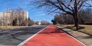
Justification:  The viewshed from the Civil War Monument/Entrance to Signal Hill Park along Signal View Dr should be maintained.  See picture below.

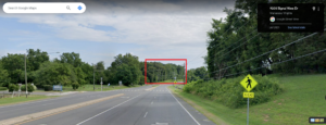
The current view from Signal View Drive (from Google Maps Street View)

Thank you for considering these recommendations as the Mayfield Crossing Rezoning project moves through the rezoning process.

###

NoVA Trails Summit, October 20, 2022

The Northern Virginia Regional Commission (NVRC) will host a Northern Virginia Recreational Trails Summit on Thursday, October 20, 2022 from 10 am to 2:30 pm at its offices at 3040 Williams Drive, Suite 200, Fairfax VA 22031.

This will be a working meeting to identify opportunities to create connections and improve communities through recreational trails in Northern Virginia.

The Northern Virginia Regional Commission and partner organizations invite all interested jurisdictions and organizations to partner and share thoughts and ideas on how to improve our communities through the coordination and development of trails and parks.

Interested representatives and staff, community organizations, and businesses can register a member or representative.   NVRC and our partners look forward to a diverse and engaging group of attendees and would love to see new faces and hear new voices!  Space is limited, so please register early!

To learn more about NVRC and its role in the Potomac Heritage National Scenic Trail visit https://www.novaregion.org/299/Potomac-Heritage-National-Scenic-Trail.

« Older posts