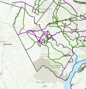
October 2023 draft update of the National Capital Trail Network in greater Prince William. The green lines are supposed to depict existing trail segments, whereas the purple lines are supposed to depict “planned” trail segments.
The National Capital Trail Network (NCTN) is a 1,400-mile, continuous network of long-distance, off-street trails, serving the entire [metropolitan Washington] region and consisting of both existing and planned segments. The network was approved by the National Capital Region Transportation Planning Board (TPB) in July 2020 and endorsed by the Metropolitan Washington Council of Governments Board of Directors in August 2020.
As described by TPB staff: The National Capital Trail Network is intended to be a network of long-distance, off-street facilities. It will be accessible for people of all ages and abilities, designed for non-motorized use, and suitable for both transportation and recreation. Off-street path width minimums are 10 feet for new construction, 8 feet for existing paths. Paths must be paved or firm surface. On-street facilities must be protected from moving traffic (i.e. parked cars, curbs, or flexposts). All facilities must be directly connected to the network. Short on-street connections on low-volume, low speed streets are permitted to maintain network continuity. Facilities can be existing or planned, but they must be in an approved agency plan.
In June 2022, the TPB adopted a resolution (R18-2022) that called for completing the TPB’s National Capital Trail Network by 2030, as one of seven priority strategies for reducing greenhouse gas emissions from surface transportation in the Washington region.
For at least several months, the TPB staff have sought to engage the region’s localities to submit updates and corrections to the NCTN map. The main purpose of this update is to measure progress, in miles built, toward the completion of the National Capital Trail Network since its adoption in 2020. Other purposes include adjusting routes where the existing route has proven infeasible or undesirable, addition of new routes where a new plan or new development justifies it, and correction of errors or omissions in the network [emphasis added].
To facilitate this update, Active Prince William submitted the comments below on October 30, 2023.
Comments on the Draft Update to the National Capital Trail Network Map for Prince William County and the City of Manassas
by Allen Muchnick, Co-Chair Active Prince William
1) Nonexistent/”Planned” Trail Segments Erroneously Labeled As “Existing”: The following segments on the NCTN map should be relabeled as “planned” because they do not currently exist.
- Nokesville Rd/Rte 28 between the Fauquier County Line and Fitzwater Dr in Nokesville. The segment of Rte 28 west of Fitzwater Dr in Nokesville has not been widened. It’s still a two-lane road without any bicycle or pedestrian facilities.
- Minnieville Rd, between Old Bridge Rd and Dumfries Rd, is depicted as having an existing shared use path along it except for the segment (TIP_ID BP11611) between Fowke Ln and Cardinal Drive. However, the NCTN update map erroneously shows this planned segment with a southwest terminus at Smoketown Rd, rather than at Cardinal Dr. The segment of Minnieville Rd that currently lacks any bicycle facilities is much longer than shown on the NCTN update map.
2) NCTN Segments Currently Labeled As Planned That Have Recently Been Completed: The following NCTN segments should now be relabeled as “existing”.
- Nokesville Rd/Rte 28 Shared-Use Path, between Godwin Dr and the PWC Line, in the City of Manassas (TIP_ID 11606).
- Godwin Dr Shared-Use Path (south), between Wellington Rd and the Winters Branch Trail, in the City of Manassas (TIP_ID BP11604). Note: TIP_ID BP7624 appears to be a duplicate path, possibly on the PWC side of Godwin Dr, which is probably not actually planned and, if so, should be deleted from the map.
- US-1 Shared-Use Path in North Woodbridge (southern segment of TIP_ID BP7634): The segment between Annapolis Way and Gordon Blvd is complete.
- Blackburn Rd Shared-Use Path near Neabsco Creek (the bulk of TIP_ID BP7641): The segment between Rippon Blvd and Good Shepherd Lutheran Church is complete.
- Wellington Rd Shared-Use Path (the western end of TIP_ID 7632): The segment between Linton Hall Rd and University Blvd near Gainesville/Virginia Gateway is complete.
- VA 234/Dumfries Rd Shared-Use Path (TIP_ID BP7639): This former gap segment between Country Club Dr and Exeter Dr near Montclair is complete.
3) Planned NCTN Segments Depicted On An Erroneous Alignment:
- I-66 Parallel Trail: The map erroneously depicts a planned NCTN segment (TIP_ID BP7636) along the north side of I-66 and through the Manassas Battlefield National Park between the crossing of Bull Run at the Fairfax County line and Pageland Lane. In fact, the planned route of the I-66 Parallel Trail in Prince William County runs along the south side of I-66 along Balls Ford Road from the crossing of Bull Run to Groveton Rd. Moreover, the portion of this trail along Balls Ford Road between Sudley Rd/Business Rte 234 and Groveton Rd (or more accurately the 1.2 miles between Ashton Ave and Doane Dr) has reportedly just completed construction.
4) Planned NCTN Segments That Should Be Updated:
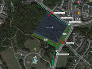
- Manassas Dr east of Signal View Dr in Manassas Park (TIP-ID BP7643): The new Manassas Park Active Transportation Plan identifies an even larger segment of eastern Manassas Dr (between Railroad Dr and Blooms Park) as a candidate for bicycle lanes implemented with a road diet (Project B-10). The NCTN map currently labels the segment of Manassas Dr east of Signal View Dr as planned for a shared-use path.
5) Nationally Significant Long-Distance Trails That Should Be Added to the NCTN Map As “Planned NCTN Segments”:
- US Bicycle Route 1: At present, a considerable portion of US Bicycle Route 1 through Prince William County is quite hostile to bicycling, even by experienced cyclists. However, the segments of this route along Fleetwood Dr (Fauquier County Line to Aden Rd), Aden Rd (Fleetwood Dr to Bristow Rd), Bristow Rd (Aden Rd to Independent Hill Dr), Independent Hill Rd (Bristow Rd to Route 234), all of Hoadly Rd, Minnieville Rd (the segment missing a shared-use path from Prince William Pkwy to Fowke Ln), and Old Bridge Rd (Minnieville Rd to Tanyard Hill Rd) are all identified for future shared-use paths in Prince William County’s December 2022 Comprehensive Plan and therefore should be depicted as Planned NCTN segments on the updated NCTN map.
- East Coast Greenway and Potomac Heritage National Scenic Trail: Except to depict existing or planned sidepaths along Route 1, the current NCTN map does not depict most of the planned ultimate route(s) for the East Coast Greenway and the paved, shared-use segments of the Potomac Heritage National Scenic Trail through Prince William County. The updated NCTN map should depict those planned routes.
###