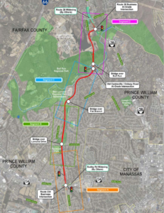
Advancing active mobility in greater Prince William, Virginia

Category: Prince William County (Page 3 of 6)

Our Input for the Route 234-Clover Hill Road Bowtie Intersection

2017 Concept for a Clover Hill Road/Prince William Parkway “Bowtie” Intersection

Recently, the Prince William County Department of Transportation asked for our feedback on their proposed preliminary design for rebuilding the intersection of the Prince William Parkway (Route 234) and Clover Hill Road near Manassas as an “innovative” bowtie intersection, where all direct left turns are eliminated and instead accommodated via two roundabouts on the minor cross street.   Our reply is posted below.   We will track this upcoming project in the coming years as the design is refined for construction.


Thank you for soliciting Active Prince William’s input on how the redesigned intersection of Clover Hill Road at the Prince William Parkway can best serve people walking and bicycling.

Conventional On-Road Bike Lanes Are Appropriate for Clover Hill Road

Clover Hill Road provides an important low-traffic bicycling connection between the City of Manassas (and adjacent residential neighborhoods within the County) and Manassas Regional Airport and points west, including the Broad Run VRE station and the new Route 28 shared-use path that now extends though Bristow all the way to Nokesville.  On the southwest side of Route 234, Clover Hill Road provides critical bicycling access to a network of low-traffic, bicycling-friendly roads within and near Manassas Regional Airport, including Harry J Parrish Blvd. Wakeman Drive, Observation Drive, Piper Lane, Residency Road, Pennsylvania Avenue, Carolina Drive, and Gateway Blvd.

As such, Clover Hill Road is eminently useful for bicycle commuting to employment sites within and near the airport, to the Broad Run VRE station, and to points west in Bristow.  In addition, Clover Hill Road and the low-traffic roads within and around the airport are used extensively for recreational bicycling on evenings and weekends.

Bicyclists on Bull Run Bicycle’s Tuesday evening shop ride wait to cross Route 234 at Clover Hill Road. To avoid hazardous right-turning traffic on both sides of this intersection, the group waits for a green traffic signal in the left travel lane of Clover Hill Road.

Both City of Manassas roadways that connect to this segment of Clover Hill Road–i.e.. Clover Hill Road from Godwin Drive to Wellington Road and Godwin Drive from Clover Hill Road to Hastings Drive–already have conventional on-road bike lanes.  Thus, in addition to including sidewalks for pedestrians, the entire redesigned segment of Clover Hill Road should include conventional on-road bike lanes in both directions.

Note that VDOT’s website that describes bowtie intersections includes conventional on-road bike lanes on all four legs of that intersection (see the illustration copied below).

Since, as in the above illustration, the proposed design features dedicated right-turn-only lanes on Clover Hill Road at both approaches to the Prince William Parkway, it would be vital to install the bike lanes at both approaches to the Prince William Parkway between the straight-through travel lane on the left and the right-turn-only lane at the curb.

Within the roundabouts, the bike lanes–if any–should be on the far right and could be buffered or physically separated from roadway traffic.  Alternatively, especially if right-of-way is constrained at the roundabouts, the bike lanes could be discontinued within the roundabouts and bicyclists encouraged to navigate the roundabouts as either a driver centered within the travel lane or (using strategically placed curb ramps for access and egress) as a pedestrian using the sidewalk.

However, upon exiting each roundabout, right-turning motorists should be directed to yield to any bicycle traffic ahead and to carefully merge right across the continued bike lane to enter the emerging right-turn-only lane before reaching either the Parkway (along both southbound and northbound Clover Hill Road) or Godwin Drive (along northbound Clover Hill Road).

Please note that these same conflicts between right-turning motorists and straight-through bicyclists presently exist at the current Clover Hill Road/Route 234 Intersection in the absence of any bike lanes and that appropriate traffic engineering measures, involving pavement markings and signage, can optimize the safety of all road users.

Design This Intersection to Safely Accommodate the Future Shared-Use Path Along Route 234

Although this project won’t construct the long-planned missing shared-use path along Route 234, the design of this intersection should not preclude its future construction and should also ensure that pedestrians and bicyclists using that shared-use path can cross Clover Hill Road safely.  As a designated segment of the National Capital Trail Network, a continuous, high-quality shared-use path along Route 234 should be a priority for Prince William County.

Unobstructed right-of-way should be acquired and preserved as part of this project to accommodate the future Route 234 shared-use path, and the project design should ensure that the route and future design of this path would not be blocked or compromised by noise barriers, above-ground or buried utilities, or roadside signage, traffic signals, or street lighting.  Until the county decides whether this path will be constructed on the northeast or southwest side of Route 234, right-of-way should be reserved for the future shared-use path on both sides.

In addition, the intersection design should ensure that the future Route 234 Trail will have a safe, at-grade crossing of Clover Hill Road, presumably coordinated with the same traffic signal that regulates the Route 234 traffic.

Eliminate High-Speed Right-on-Red Turning Movements from Route 234 onto Clover Hill Road

Unlike VDOT’s model bowtie intersection illustrated above, the currently proposed intersection design incorporates two free-flowing, high-speed, right-turning movements, using pork-chop islands, for Route 234 traffic to enter Clover Hill Road.  We believe this currently proposed design feature would seriously endanger both 1) bicyclists and pedestrians crossing Route 234 at Clover Hill Road and 2) the users of the future Route 234 Trail crossing Clover Hill Road.

Vulnerable, non-motorized road and trail users who are crossing either roadway on a green traffic signal should not be endangered by high-speed traffic that is simultaneously turning right-on-red at near-freeway speeds at these pork-chop islands.  While a decision to completely ban all right-turn-on-red movements at this intersection might best be made by expert traffic engineers, we firmly believe that free-flowing right-on-red movements would be dangerous at this intersection and should not be promoted by design features such as pork-chop islands.

Instead, vehicle traffic entering Clover Hill Road from Route 234 should be encouraged to slow to the 25 MPH posted speed and carefully merge into the single travel lane approaching the roundabout, while bicyclists who have just crossed Route 234 on a green signal must merge into the bike lane at the right edge of the roadway.

Again, careful pavement marking and signing would help all road users safely negotiate these conflicts, whereas a design that promotes high-speed right-on-red vehicle traffic would endanger vulnerable road users.

Bicyclists and pedestrians crossing Route 234 at Clover Hill Road on a green traffic signal would primarily be endangered by motorists turning right-on-red from Route 234 at the far side of their crossing.  By contrast, users of the future Route 234 Trail crossing Clover Hill Road on a green traffic signal could encounter both motorists turning right-on-green from Route 234 as well as motorists turning right-on-red from Clover Hill Road.   All such right-turning movements would be safer if the design encourages motorists to slow or stop completely before entering a crosswalk and turning into the path of vulnerable road users.  Partial traffic signal phasing, such as leading pedestrian intervals, could also make these crossings safer.

Clover Hill Road is a local street posted for 25 MPH, and there is no compelling need to promote free-flowing right-turn-on-red vehicle movements onto Clover Hill Road.

The 2019 AADT for all connected local roadways (i.e., Clover Hill Road, Godwin Drive, and Harry J Parrish Blvd) ranges from 2100 to 4700, so Clover Hill Road only needs one travel lane per direction between intersections. The proposed design includes a grassy median along Clover Hill Road, but there’s no compelling need for a grassy median on a road posted for 25 MPH, and that grassy median is about a full-lane wide on the segment approaching Godwin Dr.

Active Prince William also supports the inclusion of a shared-use path along this entire segment of Clover Hill Road; however, such a path would not connect to any existing path along Clover Hill Road, Godwin Drive or Harry J. Parrish Blvd, and it appears that the long-planned path along the Route 234 Bypass won’t be built for the foreseeable future.  Thus, a shared-use path seems less essential, especially on the airport side of Route 234, provided that both sides of Clover Hill Road will have sidewalks and bike lanes.

If spatial or terrain constraints would otherwise preclude the addition of both on-road bike lanes and sidewalks along Clover Hill Road in both directions, consideration should be given to narrowing or eliminating the grassy medians.

Thank you for considering our input.

###

Our Comments on PWC’s Proposed Transit Alternatives Map

Prince William County’s Proposed “Future Transit Alternatives Map” Dated March 17, 2022

On April 15, 2022, Active Prince William submitted the following public comments on the draft “Future Transit Alternatives Map” that defines the public transportation element for the update to Prince William County’s Comprehensive Plan known as “Pathways to 2040”.


1) The Future Transit Alternatives Map needs to identify specific sites for proposed High-Capacity Transit stations that would exist by the year 2040.

The Metropolitan Washington Council of Governments needs to accept those sites on its map of High Capacity Transit Station Areas and to agree that they qualify as “Regional Activity Centers” (using the MWCOG definition of that term), so Prince William’s 2040 Comprehensive Plan is consistent with the Metropolitan Washington Planning Framework for 2030.

Unless specific station sites are identified, the Mobility Chapter will not be integrated with the Land Use and Housing Chapters.  Identifying the planned locations of future VRE and Metrorail stations is required for the Land Use Chapter (including Land Use Map) to specify where new Transit-Oriented Development (TOD) will be planned within walking distance of High-Capacity Transit Stations.  Identifying the planned locations of future VRE and Metrorail stations is required for the Housing Chapter to plan to meet regional housing targets set with MWCOG.

MWCOG’s Regional Housing Targets

2) The Future Transit Alternatives Map should clarify if all projects shown on the map are planned to be completed by 2040.   If some projects will have a longer time frame, then the projects planned to be completed by 2040 should be identified clearly or included on a separate map.  In particular, the proposed extensions of the Metrorail Orange Line and the VRE Manassas Line are redundant, and both are likely unnecessary with the advent of the I-66 Express Lanes.  The Future Transit Alternatives Map should clearly identify that the existing I-95 and imminent I-66 Express Lanes are “existing” High-Capacity Transitways.

Knowing what projects are expected to be built over the next 20 years is necessary so other Comprehensive Plan policies, action strategies, and projects can be budgeted and synchronized.  Maps showing planned roads and trails should also identify projects planned for completion by 2040, plus other aspirational projects using the same approach for transit projects.

3) The Mobility Chapter should include action strategies to acquire right-of-way for the proposed route of the Orange Line to Gainesville or that project should be removed from the map.  Unless located within the I-66 right of way, the right-of-way for the Orange Line extension may require going through Bull Run Regional Park, Manassas National Battlefield Park, and/or high-value commercial properties.  Fairfax County committed almost $60 million to preserve right-of-way along the I-66 corridor for extending Orange Line to Centerville during expansion to create Express Mobility Partners toll lanes, but Prince William preserved no right-of-way–suggesting a proposal for extending the Orange Line to Gainesville is more of a fantasy than an actual plan.

4) If the proposed route of the Orange Line to Gainesville remains on Future Transit Alternatives Map , then the Land Use Chapter should include plans for town centers with T-5 and T-6 Transect Zones at the station locations.

5) The Mobility Chapter should define the southern terminus of the proposed Blue/Yellow Line in eastern Prince William, and that terminus should subsequently be identified in the Visualize 2045, TransAction, and VTrans plans.

6) The Mobility Chapter should include action strategies to acquire right-of-way for the proposed route of the Blue/Yellow Line to Triangle or of the proposed BRT system.

7) The proposed route of the Blue/Yellow Line to Triangle , or of the proposed BRT system, should be clarified so it will be clear what land parcels will be suitable for Transit-Oriented Development.  In particular, it should be clear if the large Potomac Mills site will have a High-Capacity Transit station at one edge, because portions of that property could end up more than one-half mile from a station.

8) The Quartz development at the intersection of Minnieville Road and Prince William Parkway, and the intersection of Dale Boulevard-Minnieville Road should not be designated as “MultiMobile Hubs” if those sites will not have a High-Capacity Transit station.  Bus stops with commuter lots technically might be “multimobile,” but should not be planned for the same level of development as sites with a High-Capacity Transit station.

Proposed “Future Transit Alternatives” for Eastern Prince William County

9) Plans for town centers with T-5 and T-6 Transect Zones should be included in the Land Use Map for all sites in eastern Prince William where a High-Capacity Transit station is planned.

10) Action strategies in the Mobility Chapter should identify how to obtain local, state, and Federal funding for extension of Metrorail to Prince William, creation of a Bus Rapid Transit system and shuttle/trolley systems, and development of infrastructure for the proposed commuter ferry.

11) The Land Use Map should identify where affordable housing is planned within walking distance of planned High-Capacity Transit stations, in order to meet the MWCOG targets.  Families are cost-burdened if housing costs exceed 30% of Area Median Income, but also cost-burdened if housing and transportation costs combined exceed 42% of Area Median Income.

12) The 2040 Comprehensive Plan should quantify the shortage of affordable housing units for families earning 30%, 50%, and 80% of Area Median Income now, and the projected shortage in 2030 and 2040.  The Land Use Map should identify where new affordable housing will be developed by 2030 and 2040 to eliminate the shortage of affordable housing in those three categories, and those locations for new affordable housing should be planned within walking distance of High-Capacity Transit stations.

13) More-detailed shuttle/trolley routes and boundaries of areas where service is planned should be identified on the Future Transit Alternatives Map.  The Mobility Chapter should include an action strategy to complete and update regularly origin and destination studies for proposed shuttle/trolley routes, in order to integrate the Mobility Chapter with other 2040 Comprehensive Plan chapters and with the Comprehensive Plans in the Cities of Manassas and Manassas Park. Shuttle/trolley routes should be structured to connect Activity Centers as defined by MWCOG and also nodes of existing/planned dense development as shown on the Land Use Map.

14) An action strategy should be included in the Mobility Chapter to identify the year when shuttle/trolley service will become operational, so rezonings and construction plans can be synchronized.

15) If “[s]pecific objectives include adapting to changing mobility trends, improving multi-modal options, increasing the use of public transit, increasing travel time reliability while concurrently striving to decrease the use of vehicle fuels that contribute to climate change,” then the Mobility Chapter needs to add Local and Express Bus Service maps showing areas to be served by bus service and the stages in which that service will be expanded over the next 20 years.  Upgrading local bus service to facilitate access to local jobs, schools, healthcare, retail, and other key destinations for less-advantaged households is at least as essential as extending commuter rail routes that carry white-collar workers out of Prince William. Upgrading low-cost local transit and upgrading bike/pedestrian access offers the greatest opportunity to invest in upgrading equity.  Fairfax Connector Transit Strategic Plan Update offers an understandable format that can be used to support comprehensive plan update effort

16) “High-Capacity Transit”, as identified on this map, should be adequately defined in terms of weekday boardings, peak-period headways, and service hours.  Bus service that operates for fewer than 16 hours on weekdays, has peak-period headways longer than 15 or 20 minutes, or experiences fewer than 500 daily boardings is merely ordinary transit service.

17) The “High-Capacity Transit” lines in the western part of the county, which lack connections to Downtown Manassas, the Manassas Park City Center, the Godwin Drive Technology Corridor, and Sudley Road/Route 234 Business, are missed opportunities.  Recommend coordinating with Omniride which represents the entire Greater Manassas area.

###

Will Prince William’s Road Expansions Bust Our Region’s Climate Goals?

To lessen catastrophic climate change from the burning of fossil fuels, the Metropolitan Washington Council of Governments (MWCOG) has collectively pledged to substantially reduce our region’s emissions of greenhouse gases (GHG) from the level that existed in 2005–by 50% by 2030 and by 80% by 2050.

The major sources of our region’s greenhouse gas emissions.  Transportation (yellow bars) is now the largest single source of our greenhouse gas emissions, comprising at least 40% of the total.

Prince William County and all other localities in the Metropolitan Washington Council of Governments (MWCOG)–and the associated National Capital Region Transportation Planning Board (TPB)–have committed to reduce greenhouse gas emissions to 50% of the 2005 level by 2030.  In the County, the transportation sector–cars and trucks, primarily–is the largest source of greenhouse gas emissions.   By 2030, there will be more electric vehicles (and a somewhat cleaner electric grid), but most vehicles will still be powered by fossil fuels and emit carbon dioxide from tailpipes.

The County’s traditional business-as-usual transportation planning–expanding highways for drive-alone commutes–would sabotage efforts to meet the 2030 target.  In particular, the proposed Route 28 Bypass would not increase local jobs but would increase solo auto commutes and greenhouse gas emissions.  Spending well over $200 million in County tax revenue on the Route 28 Bypass would subsidize housing and jobs in other localities, while sabotaging efforts to meet our region’s 2030 greenhouse gas target to lessen our global climate crisis.

Instead of building the Route 28 Bypass, the eight members on the Board of County Supervisors (BOCS) could plan to meet our region’s 2030 climate target and invest the savings to upgrade local infrastructure to better access local jobs.  What makes the most sense to you?

Below is our recent email exchange with BOCS Chair (and TPB Member) Ann Wheeler.   Active Prince William sent similar messages to Neabsco District Supervisor Victor Angry, Manassas Vice Mayor Pamela Sebesky, and Manassas Park Mayor Jeanette Rishell who also serve on the National Capital Region Transportation Planning Board (TPB).


From: Active Prince William <[email protected]>
Sent: Thursday, March 31, 2022 6:46 PM
To: Wheeler, Ann <[email protected]>; Angry, Victor S. <[email protected]>
Cc: Belita, Paolo J. <[email protected]>; Canizales, Ricardo <[email protected]>
Subject: Metropolitan Washington 2030 Climate and Energy Action Plan

Dear Chair Wheeler and Supervisor Angry:

As members of the Transportation Planning Board (TPB), you have an especially important role in sustainability planning and advancing the Metropolitan Washington 2030 Climate and Energy Action Plan.  

Without action by TPB to adopt climate change mitigation goals and strategies, the region will not meet the 2030 and 2050 targets to reduce greenhouse gas emissions.  

Technological changes will not be sufficient; we need policy changes that reduce regional VMT and VMT per capita as well.  Fundamentally, the TPB must adopt targets and policies to reduce carbon emissions from the transportation sector.  The impact of new projects in Northern Virginia’s long-range multimodal transportation plan, TransAction, need to be quantified.  Otherwise, how can the 24 jurisdictions in MWCOG meet their 2030 and 2050 targets?

Similarly, each jurisdiction needs to “do the math” regarding planned land use changes.  Transit-Oriented Development can minimize the greenhouse gas emissions that will be increased by population growth.  Those increases must be offset in order to meet the 2030 and 2050 targets, and the impact of changes in land use planning must be quantified. Otherwise, how can the 24 jurisdictions in MWCOG meet their 2030 and 2050 targets?

As noted by the Coalition for Smarter Growth, the 2030 target to reduce greenhouse gas emissions to 50% below 2005 levels is essential for keeping our planet in the safety zone.  We cannot afford to ignore the cumulative impacts of emissions between now and 2030 and focus only on the 2050 target.


From: Wheeler, Ann <[email protected]>
Date: Mon, Apr 4, 2022 at 1:12 PM
Subject: RE: Metropolitan Washington 2030 Climate and Energy Action Plan
To: Active Prince William <active.princewilliam@gmail.com>, Angry, Victor S. <[email protected]>
Cc: Belita, Paolo J. <[email protected]>, Canizales, Ricardo <[email protected]>

Good afternoon-

Thank you for reaching out to our office.  I have attached the MWCOG plan for achieving GHG reductions.  As you can see on page 11 there will have to be various ways to address this issue and I know both MWCOG and TPB have discussed these at length.  Prince William County is a still growing outer jurisdiction, without Metro, which makes discussion of some of the items you brought up more difficult.  It is my belief that as an outer jurisdiction, with a current heavy reliance on automobiles, we should have a much, much greater focus on electrification of our County-owned fleet as well as encouragement of conversion to EVs through a robust charging infrastructure for our residents.  Even looking at the major activity or transit centers in the west where the housing growth will come from (Broad Run Station, the commuter lot on Route  29 and the commuter lot at Groveton) it will be difficult to get very high density around these three locations for various reasons.   I believe one of the strongest ways to ultimately reduce vehicle miles traveled is to expand our commercial base in Prince William County so people don’t have to commute to their job locations and that is what I am focusing on.  I am sure you will agree that ultimately this is a goal everyone can get behind.

Thank you for you comments as we continue evaluating our land-use and mobility plans to assure our future for the next twenty years.

In service,

Ann Wheeler


From: Active Prince William <active.princewilliam@gmail.com>
Date: Mon, Apr 4, 2022 at 6:31 PM
Subject: Re: Metropolitan Washington 2030 Climate and Energy Action Plan
To: Wheeler, Ann <[email protected]>
Cc: Angry, Victor S. <[email protected]>, Belita, Paolo J. <[email protected]>, Canizales, Ricardo <[email protected]><

Chair Wheeler,

Thank you for your response to our message regarding the need to reduce greenhouse gas emissions from the transportation sector.  We certainly agree that “one of the strongest ways to ultimately reduce vehicle miles traveled is to expand our commercial base in Prince William County so people don’t have to commute to their job locations.”

That perspective should shape the county’s investments in new transportation infrastructure.  We should prioritize building new capacity that maximizes mobility while minimizing Vehicle Miles Traveled.  The 2040 Comprehensive Plan should focus on creating walkable communities to accommodate the expanding population.  The County priority for new mobility infrastructure should be expansion of local Omniride and shuttle/trolley services, plus bike/pedestrian connections that anticipate increasing use of e-bikes.

To expand our commercial base and increase local jobs, we should stop funding construction of new lane miles designed for Prince William commuters to leave the county–and for auto commuters who live to our west and south to commute through Prince William County–for jobs in other jurisdictions.  In particular, the county’s $200 million subsidy for the Route 28 Bypass is inconsistent with a priority to expand our commercial base in Prince William County so people don’t have to commute to their job locations.

That project, especially when the destruction of houses in an Equity Emphasis Area is viewed through an equity lens, should be cancelled.  The funding earmarked to repay the $200 million in county bonds, should be re-purposed in a joint venture with the school system to fund the Sustainability Action Plan that the Sustainability Commission will complete in the next year.

###

While Better, the Revised Design of the Route 234-Brentsville Road Interchange in Still Badly Flawed

Prince William County DOT’s currently proposed circuitous trail routing through the Interchange, assuming that a direct trail bridge connecting the existing Route 294 and Route 234 Trails is included in this project

Our proposed trail connections through the planned interchange to reach Route 234 Business (red line) and the future trail along the Route 234 Bypass (blue line).  A trail (red line) running along the north side of Route 234 would pass underneath both new roadway overpasses. The three light blue circles show where box culverts could allow the trail to be routed beneath highway ramps.  The areas shown in yellow are existing roadways that are planned to be removed.  This design eliminates all at-grade trail-roadway crossings, except to reach Route 234 Business.  However, by building a shared-use path along the west side of Route 234 Business (connecting to Godwin Dr), trail users would be required to cross only 5-lanes of stopped traffic at just the western leg of the signalized intersection of Bradley Cemetery Way and Route 234 Business, not 12-lanes of stopped traffic plus one lane of free-flowing right-turning traffic at two separate legs of that intersection.

This post follows up on the comments we previously submitted in response to the December 8, 2021 Design Public Hearing for Prince William County DOT’s Route 234-Brentsville Road Interchange Project.

On March 18, 2022, the County released this followup video presentation on the proposed project design.   County DOT staff are willing to at least partly addresses three concerns with the proposed trail connections that were raised at the Design Public Hearing:

1) In response to public comments from Active Prince William and others, the County is now studying the cost feasibility of a new, dedicated trail bridge over Rte 234, just east of the interchange, to directly connect the existing trails along Route 234 and Route 294.   If this trail bridge can be added without the project exceeding it’s $55 million budget, it will be included in this project.   Otherwise, it probably won’t.

2) In response to safety concerns raised by many about the four proposed closely spaced at-grade trail crossings of free-flowing highway ramps near Route 294 and Bradley Cemetery Way in the northeast corner of this project, those hazardous at-grade trail crossings may not be built, at least if the added trail bridge discussed above is actually built.    However, this change would produce a long, circuitous trail route between the western legs (Route 234 Bypass and Route 234 Business) and eastern legs (the existing trails along Routes 234 and 294) of this interchange (shown in the top image above).

3) In response to objections that the design completely omits the long-planned trail along the Route 234 Bypass that should join the existing trails along Route 234 and Route 294,  the design team has identified a future location for this trail along the northwestern edge of the interchange (see the blue line in the second image above).

However, all trail connections to and from Route 234 Business and the long-planned future trail along the Route 234 Bypass (aka Route 234 North) would still require a two-stage at-grade crossing of 12 signalized traffic lanes plus one free-flowing right-turn lane at the rebuilt intersection of Bradley Cemetery Way and Rte 234 Business plus a second at-grade trail crossing of a free-flowing highway ramp at the south side of the interchange (at the on-ramp from Brentsville Road) .  Those remaining design flaws would still create considerable delays and hazards for trail users.

Under Prince William DOT’s revised design for this interchange, this slow and hazardous crossing of 13 traffic lanes at two legs of the signalized intersection of Bradley Cemetery Way and Route 234 Business would remain.  All trail access and egress from either Route 234 Business or the future trail along the Route 234 Bypass would need to use this routing to join either of the existing trails along Route 234 and Route 294 or Brentsville Road.

As a followup proposal, we suggest routing the long-planned trail along the Route 234 Bypass along the north side of Route 234 (per the second image from the top), connecting that trail to both the existing Route 294 Trail to the east and to a new shared-use path along the west side of Route 234 Business (where the existing pavement, depicted in yellow, is planned for removal).   This trail (depicted with a red line in that image) would pass underneath both new roadway overpasses being built to carry Brentsville Road and Route 294 over Route 234 and could also pass underneath three single-lane interchange ramps inside box culverts (see the light blue circles).

Under our proposal, the long-planned trail along the Route 234 Bypass would run along the north side of Route 234 and pass under both planned roadway bridges.


Three short box culverts could be used to route our proposed trail along the north side of the Route 234 Bypass beneath three one-lane interchange ramps.  Only one such box culvert would be needed for the connection to Route 234 Business.

Our proposed design eliminates all at-grade trail-roadway crossings, except to reach Route 234 Business.  However, by building a shared-use path along the west side of Route 234 Business (connecting to Godwin Dr), where only a sidewalk is currently planned, trail users would be required to cross only 5-lanes of stopped traffic at just the western leg of the signalized intersection of Bradley Cemetery Way and Route 234 Business, not 12-lanes of stopped traffic plus one lane of free-flowing right-turning traffic at two separate legs of that intersection.

Our proposal could also lower the cost of this project by eliminating the need to include a 14-foot wide shared-use path on the proposed Brentsville Road bridge.

Active Prince William believes that first-class, safe and direct trail connections for all five legs of this interchange can and should be provided within this project’s existing budget of $55 million.

Tour of Prince William Bicycling Event, July 23, 2022

Participate in the

2022 Tour of Prince William

to benefit the 501(c)(3) Prince William Trails and Streams Coalition and the 501(c)(3) Prince William Historic Preservation Foundation

When:  Saturday, July 23, 2022

Start time:  7:00 – 9:00 a.m. (no mass start)

Starting Location:  Brentsville Courthouse Historic Center
12229 Bristow Road, Bristow, VA 20136

Courses:  20-mile and 62-mile (metric century) rides

Cost:  $40 by May 31, $45 by June 30, $50 by July 22, and $55 in person July 23.

Course Description:  The courses introduce bicycle riders to the wide variety that is Prince William County.  Wind through urban, suburban, exurban, rural, forested, town, flat, and hilly areas.  Bicycle riders will visit two of Prince William County’s historic properties.

Registration opens April 11, 2022, and additional information is available now at www.tourofprincewilliam.org

« Older posts Newer posts »