Active Prince William

Advancing active mobility in greater Prince William, Virginia

Page 8 of 25

Will Prince William’s Road Expansions Bust Our Region’s Climate Goals?

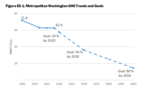
To lessen catastrophic climate change from the burning of fossil fuels, the Metropolitan Washington Council of Governments (MWCOG) has collectively pledged to substantially reduce our region’s emissions of greenhouse gases (GHG) from the level that existed in 2005–by 50% by 2030 and by 80% by 2050.
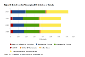
The major sources of our region’s greenhouse gas emissions.  Transportation (yellow bars) is now the largest single source of our greenhouse gas emissions, comprising at least 40% of the total.

Prince William County and all other localities in the Metropolitan Washington Council of Governments (MWCOG)–and the associated National Capital Region Transportation Planning Board (TPB)–have committed to reduce greenhouse gas emissions to 50% of the 2005 level by 2030.  In the County, the transportation sector–cars and trucks, primarily–is the largest source of greenhouse gas emissions.   By 2030, there will be more electric vehicles (and a somewhat cleaner electric grid), but most vehicles will still be powered by fossil fuels and emit carbon dioxide from tailpipes.

The County’s traditional business-as-usual transportation planning–expanding highways for drive-alone commutes–would sabotage efforts to meet the 2030 target.  In particular, the proposed Route 28 Bypass would not increase local jobs but would increase solo auto commutes and greenhouse gas emissions.  Spending well over $200 million in County tax revenue on the Route 28 Bypass would subsidize housing and jobs in other localities, while sabotaging efforts to meet our region’s 2030 greenhouse gas target to lessen our global climate crisis.

Instead of building the Route 28 Bypass, the eight members on the Board of County Supervisors (BOCS) could plan to meet our region’s 2030 climate target and invest the savings to upgrade local infrastructure to better access local jobs.  What makes the most sense to you?

Below is our recent email exchange with BOCS Chair (and TPB Member) Ann Wheeler.   Active Prince William sent similar messages to Neabsco District Supervisor Victor Angry, Manassas Vice Mayor Pamela Sebesky, and Manassas Park Mayor Jeanette Rishell who also serve on the National Capital Region Transportation Planning Board (TPB).


From: Active Prince William <active.princewilliam@gmail.com>
Sent: Thursday, March 31, 2022 6:46 PM
To: Wheeler, Ann <awheeler@pwcgov.org>; Angry, Victor S. <VSAngry@pwcgov.org>
Cc: Belita, Paolo J. <PBelita@pwcgov.org>; Canizales, Ricardo <rcanizales@pwcgov.org>
Subject: Metropolitan Washington 2030 Climate and Energy Action Plan

Dear Chair Wheeler and Supervisor Angry:

As members of the Transportation Planning Board (TPB), you have an especially important role in sustainability planning and advancing the Metropolitan Washington 2030 Climate and Energy Action Plan.  

Without action by TPB to adopt climate change mitigation goals and strategies, the region will not meet the 2030 and 2050 targets to reduce greenhouse gas emissions.  

Technological changes will not be sufficient; we need policy changes that reduce regional VMT and VMT per capita as well.  Fundamentally, the TPB must adopt targets and policies to reduce carbon emissions from the transportation sector.  The impact of new projects in Northern Virginia’s long-range multimodal transportation plan, TransAction, need to be quantified.  Otherwise, how can the 24 jurisdictions in MWCOG meet their 2030 and 2050 targets?

Similarly, each jurisdiction needs to “do the math” regarding planned land use changes.  Transit-Oriented Development can minimize the greenhouse gas emissions that will be increased by population growth.  Those increases must be offset in order to meet the 2030 and 2050 targets, and the impact of changes in land use planning must be quantified. Otherwise, how can the 24 jurisdictions in MWCOG meet their 2030 and 2050 targets?

As noted by the Coalition for Smarter Growth, the 2030 target to reduce greenhouse gas emissions to 50% below 2005 levels is essential for keeping our planet in the safety zone.  We cannot afford to ignore the cumulative impacts of emissions between now and 2030 and focus only on the 2050 target.


From: Wheeler, Ann <awheeler@pwcgov.org>
Date: Mon, Apr 4, 2022 at 1:12 PM
Subject: RE: Metropolitan Washington 2030 Climate and Energy Action Plan
To: Active Prince William <active.princewilliam@gmail.com>, Angry, Victor S. <VSAngry@pwcgov.org>
Cc: Belita, Paolo J. <PBelita@pwcgov.org>, Canizales, Ricardo <rcanizales@pwcgov.org>

Good afternoon-

Thank you for reaching out to our office.  I have attached the MWCOG plan for achieving GHG reductions.  As you can see on page 11 there will have to be various ways to address this issue and I know both MWCOG and TPB have discussed these at length.  Prince William County is a still growing outer jurisdiction, without Metro, which makes discussion of some of the items you brought up more difficult.  It is my belief that as an outer jurisdiction, with a current heavy reliance on automobiles, we should have a much, much greater focus on electrification of our County-owned fleet as well as encouragement of conversion to EVs through a robust charging infrastructure for our residents.  Even looking at the major activity or transit centers in the west where the housing growth will come from (Broad Run Station, the commuter lot on Route  29 and the commuter lot at Groveton) it will be difficult to get very high density around these three locations for various reasons.   I believe one of the strongest ways to ultimately reduce vehicle miles traveled is to expand our commercial base in Prince William County so people don’t have to commute to their job locations and that is what I am focusing on.  I am sure you will agree that ultimately this is a goal everyone can get behind.

Thank you for you comments as we continue evaluating our land-use and mobility plans to assure our future for the next twenty years.

In service,

Ann Wheeler


From: Active Prince William <active.princewilliam@gmail.com>
Date: Mon, Apr 4, 2022 at 6:31 PM
Subject: Re: Metropolitan Washington 2030 Climate and Energy Action Plan
To: Wheeler, Ann <awheeler@pwcgov.org>
Cc: Angry, Victor S. <vsangry@pwcgov.org>, Belita, Paolo J. <pbelita@pwcgov.org>, Canizales, Ricardo <rcanizales@pwcgov.org><

Chair Wheeler,

Thank you for your response to our message regarding the need to reduce greenhouse gas emissions from the transportation sector.  We certainly agree that “one of the strongest ways to ultimately reduce vehicle miles traveled is to expand our commercial base in Prince William County so people don’t have to commute to their job locations.”

That perspective should shape the county’s investments in new transportation infrastructure.  We should prioritize building new capacity that maximizes mobility while minimizing Vehicle Miles Traveled.  The 2040 Comprehensive Plan should focus on creating walkable communities to accommodate the expanding population.  The County priority for new mobility infrastructure should be expansion of local Omniride and shuttle/trolley services, plus bike/pedestrian connections that anticipate increasing use of e-bikes.

To expand our commercial base and increase local jobs, we should stop funding construction of new lane miles designed for Prince William commuters to leave the county–and for auto commuters who live to our west and south to commute through Prince William County–for jobs in other jurisdictions.  In particular, the county’s $200 million subsidy for the Route 28 Bypass is inconsistent with a priority to expand our commercial base in Prince William County so people don’t have to commute to their job locations.

That project, especially when the destruction of houses in an Equity Emphasis Area is viewed through an equity lens, should be cancelled.  The funding earmarked to repay the $200 million in county bonds, should be re-purposed in a joint venture with the school system to fund the Sustainability Action Plan that the Sustainability Commission will complete in the next year.

###
Our Comments on the Mathis Avenue Improvement Project

On March 31, 2022, Active Prince William submitted the following comments to the City of Manassas regarding its proposed Mathis Avenue Improvement Project:


Re: Mathis Avenue Improvement Project (T-086) Public Meeting Comments

On behalf of Active Prince William, I’m writing to submit the following comments in response to the March 17, public meeting for the above-referenced project.  Our all-volunteer organization seeks improved active mobility and public transportation throughout greater Prince William, to create more livable, equitable, and sustainable communities.

An Improved Public Process for Transportation Project Development

We sincerely appreciate the improved process used to involve the public at the 30% design stage for this capital transportation project, which included both a February 23 virtual public meeting and an in-person meeting held on March 17.  This public involvement process is far better than the one used by City staff for its recent Sudley Road Third Lane Project, which excluded all public input before preliminary engineering was at least 90% complete (including when that project had been re-scoped substantially twice, in December 2017 and in February 2021).  We hope this public comment opportunity reflects a permanent policy change to proactively involve the public in all City transportation projects going forward, ideally starting at the project scoping stage.

The Proposed Design is a Reasonable Interim Aesthetic Improvement but Lacks Essential Pedestrian Amenities for a Vibrant, Mixed-Use Street

As a final condition for a revitalized Mathis Avenue as a mixed-use, pedestrian-oriented street–ideally with robust bus transit service–the proposed design would be a major disappointment.  However, as an interim improvement intended to transform the appearance of this somewhat desolate commercial street and to promote future mixed-use redevelopment at minimal cost, this project does appear to have merit.

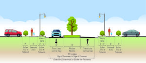
In particular, the proposed design provides sidewalks that are too narrow for comfortable two-way walking, are too close to the roadway, and lack street trees and pedestrian-serving street furniture in what should be much wider curbside planting strips and furniture zones.   In addition, the sidewalks are interrupted with frequent curb cuts, where motor vehicle cross flows impede safe and comfortable walking.

However, considering the need for Mathis Avenue to continue serving the existing auto-oriented businesses beside it, especially along the east side of this street, until redevelopment occurs some years in the future, the imperative to minimize right of way takings and to preserve the existing curb cuts is understandable.

To effectively promote the specific forms of redevelopment that the City seeks and to ensure that this redevelopment incorporates the necessary mobility infrastructure to equitably support that redevelopment, the City’s Department of Planning and Community Development should undertake a robust community-based planning process to develop a detailed form-based zoning code for the Mathis Avenue corridor.  Form-base zoning codes are a proven tool to effectively promote the specific forms of redevelopment desired by localities.

Bicycling Accommodations and Roadway Design Speed

The lack of bike lanes (or any alternative bicycle facilities) in this project is disappointing but is also understandable since the existing curbs are not being moved to keep the existing storm sewer infrastructure in place, to minimize costs and commercial property impacts.  However, without bike lanes, the construction of raised medians will degrade bicycling conditions substantially, and those degraded conditions are unlikely to be remedied by a future roadway widening when the corridor is eventually redeveloped.

Presently, motorists can readily safely overtake people riding bicycles on Mathis Avenue by passing in the two-way central left-turn lane.  The raised medians, however, will prevent motorists from overtaking bicycle riders, who typically travel at 10-16 MPH.  Thus, people riding bicycles on Mathis Avenue will serve as slow-moving traffic-calming devices.  This roadway change will make bicycling unpleasant for nearly all riders and will subject people riding bicycles to increased harassment from frustrated motorists who are unable to pass.  Moreover, since Mathis Avenue would probably not be rebuilt with added bike lanes when redevelopment occurs in the future, this degradation of bicycling conditions on Mathis Avenue is likely permanent.

The fact that nearby Portner Avenue is designated as a bicycle route is no reason to degrade bicycling conditions on Mathis Avenue.  While many through bicyclists already prefer to travel on Portner Avenue, only Mathis Avenue serves the businesses and jobs located along Mathis Avenue, and people will someday live on this segment of Mathis Avenue too.

Thus, for both bicycle access and pedestrian safety, this project should strive to reduce the design speed for Mathis Avenue–and ideally the posted speed limit–to 20 MPH or below.   The raised median with street trees—and especially street trees in future curbside planting strips and future taller buildings closer to the roadway—should encourage motorists to drive more slowly on Mathis Avenue, but other design changes are needed too.

Shorter curb-return radii at corners and narrower sidewalk curb cuts would help reduce motor vehicle speeds, and electronic speed-feedback signs paired with posted speed limit signs (dynamic speed displays) would warn speeding motorists to slow down.  In addition, shared-lane markings (aka “sharrows”) centered in each travel lane would inform both motorists and bicycle riders that this is a shared roadway.

More Visible and Shorter Crosswalks

One notable design feature that should be changed is the proposed use of brick-colored stamped asphalt crosswalks.  While intended to impart historic charm, brown-colored crosswalks are far less conspicuous to motorists than modern high-visibility and reflective thermoplastic crosswalk markings.  The primary purpose of marked crosswalks is to alert motorists to the likely presence of crossing pedestrians, encouraging drivers to slow down, look for, prepare to yield to, and stop for pedestrians who may be crossing the roadway.  A faux-brick aesthetic is far less important than the safety of people who are walking across the street.

In addition, the final design of each intersection should pay particular attention to shortening the length of all crosswalks to the extent feasible and to install two separate curb ramps for the crosswalk landings at each corner.  The present design includes a single combined curb ramp at the southeast corner of Mathis Avenue and Sudley Road and at all four corners of Mathis Avenue and Liberia Avenue, the two on the north side not being rebuilt.

Designing shorter curb-return radii at all intersection corners, as suggested above to reduce the roadway design speed, would also reduce the crosswalk lengths at those intersections.

Consider Short Left-Turn Lanes at Reb Yank Drive and Carriage Lane

The advertised design does not include any space in the center of the roadway (beyond the intersection itself) to store vehicles waiting to turn left at Reb Yank Drive (from both directions) or southbound at Carriage Lane.  While shortening the raised medians to add short left-turn pockets at those three locations could increase travel speeds along Mathis Avenue and could also remove the proposed median refuges for crossing pedestrians at those unsignalized intersections, it may be prudent to add those left-turn pockets to smooth traffic flow, reduce traffic congestion, and lower the incidence of rear-end collisions at those locations.  However, if traffic studies have already documented that those left-turn pockets are unnecessary, then please retain them.

Thank you for considering our comments as you finalize the design of this project.

While Better, the Revised Design of the Route 234-Brentsville Road Interchange in Still Badly Flawed

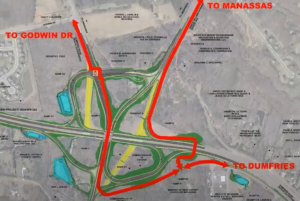
Prince William County DOT’s currently proposed circuitous trail routing through the Interchange, assuming that a direct trail bridge connecting the existing Route 294 and Route 234 Trails is included in this project

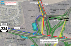
Our proposed trail connections through the planned interchange to reach Route 234 Business (red line) and the future trail along the Route 234 Bypass (blue line).  A trail (red line) running along the north side of Route 234 would pass underneath both new roadway overpasses. The three light blue circles show where box culverts could allow the trail to be routed beneath highway ramps.  The areas shown in yellow are existing roadways that are planned to be removed.  This design eliminates all at-grade trail-roadway crossings, except to reach Route 234 Business.  However, by building a shared-use path along the west side of Route 234 Business (connecting to Godwin Dr), trail users would be required to cross only 5-lanes of stopped traffic at just the western leg of the signalized intersection of Bradley Cemetery Way and Route 234 Business, not 12-lanes of stopped traffic plus one lane of free-flowing right-turning traffic at two separate legs of that intersection.

This post follows up on the comments we previously submitted in response to the December 8, 2021 Design Public Hearing for Prince William County DOT’s Route 234-Brentsville Road Interchange Project.

On March 18, 2022, the County released this followup video presentation on the proposed project design.   County DOT staff are willing to at least partly addresses three concerns with the proposed trail connections that were raised at the Design Public Hearing:

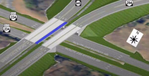
1) In response to public comments from Active Prince William and others, the County is now studying the cost feasibility of a new, dedicated trail bridge over Rte 234, just east of the interchange, to directly connect the existing trails along Route 234 and Route 294.   If this trail bridge can be added without the project exceeding it’s $55 million budget, it will be included in this project.   Otherwise, it probably won’t.

2) In response to safety concerns raised by many about the four proposed closely spaced at-grade trail crossings of free-flowing highway ramps near Route 294 and Bradley Cemetery Way in the northeast corner of this project, those hazardous at-grade trail crossings may not be built, at least if the added trail bridge discussed above is actually built.    However, this change would produce a long, circuitous trail route between the western legs (Route 234 Bypass and Route 234 Business) and eastern legs (the existing trails along Routes 234 and 294) of this interchange (shown in the top image above).

3) In response to objections that the design completely omits the long-planned trail along the Route 234 Bypass that should join the existing trails along Route 234 and Route 294,  the design team has identified a future location for this trail along the northwestern edge of the interchange (see the blue line in the second image above).

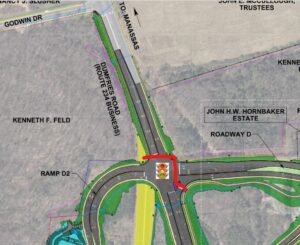
However, all trail connections to and from Route 234 Business and the long-planned future trail along the Route 234 Bypass (aka Route 234 North) would still require a two-stage at-grade crossing of 12 signalized traffic lanes plus one free-flowing right-turn lane at the rebuilt intersection of Bradley Cemetery Way and Rte 234 Business plus a second at-grade trail crossing of a free-flowing highway ramp at the south side of the interchange (at the on-ramp from Brentsville Road) .  Those remaining design flaws would still create considerable delays and hazards for trail users.

Under Prince William DOT’s revised design for this interchange, this slow and hazardous crossing of 13 traffic lanes at two legs of the signalized intersection of Bradley Cemetery Way and Route 234 Business would remain.  All trail access and egress from either Route 234 Business or the future trail along the Route 234 Bypass would need to use this routing to join either of the existing trails along Route 234 and Route 294 or Brentsville Road.

As a followup proposal, we suggest routing the long-planned trail along the Route 234 Bypass along the north side of Route 234 (per the second image from the top), connecting that trail to both the existing Route 294 Trail to the east and to a new shared-use path along the west side of Route 234 Business (where the existing pavement, depicted in yellow, is planned for removal).   This trail (depicted with a red line in that image) would pass underneath both new roadway overpasses being built to carry Brentsville Road and Route 294 over Route 234 and could also pass underneath three single-lane interchange ramps inside box culverts (see the light blue circles).

Under our proposal, the long-planned trail along the Route 234 Bypass would run along the north side of Route 234 and pass under both planned roadway bridges.


Three short box culverts could be used to route our proposed trail along the north side of the Route 234 Bypass beneath three one-lane interchange ramps.  Only one such box culvert would be needed for the connection to Route 234 Business.

Our proposed design eliminates all at-grade trail-roadway crossings, except to reach Route 234 Business.  However, by building a shared-use path along the west side of Route 234 Business (connecting to Godwin Dr), where only a sidewalk is currently planned, trail users would be required to cross only 5-lanes of stopped traffic at just the western leg of the signalized intersection of Bradley Cemetery Way and Route 234 Business, not 12-lanes of stopped traffic plus one lane of free-flowing right-turning traffic at two separate legs of that intersection.

Our proposal could also lower the cost of this project by eliminating the need to include a 14-foot wide shared-use path on the proposed Brentsville Road bridge.

Active Prince William believes that first-class, safe and direct trail connections for all five legs of this interchange can and should be provided within this project’s existing budget of $55 million.

Tour of Prince William Bicycling Event, July 23, 2022

Participate in the

2022 Tour of Prince William

to benefit the 501(c)(3) Prince William Trails and Streams Coalition and the 501(c)(3) Prince William Historic Preservation Foundation

When:  Saturday, July 23, 2022

Start time:  7:00 – 9:00 a.m. (no mass start)

Starting Location:  Brentsville Courthouse Historic Center
12229 Bristow Road, Bristow, VA 20136

Courses:  20-mile and 62-mile (metric century) rides

Cost:  $40 by May 31, $45 by June 30, $50 by July 22, and $55 in person July 23.

Course Description:  The courses introduce bicycle riders to the wide variety that is Prince William County.  Wind through urban, suburban, exurban, rural, forested, town, flat, and hilly areas.  Bicycle riders will visit two of Prince William County’s historic properties.

Registration opens April 11, 2022, and additional information is available now at www.tourofprincewilliam.org

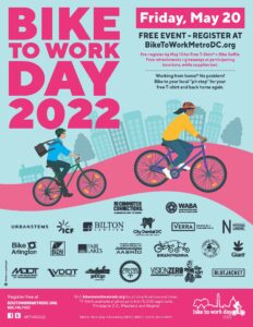
Celebrate Bike to Work Day on Friday, May 20

Registration is now open for Metropolitan Washington’s Bike to Work Day 2022 on Friday, May, 20.

This FREE event features roughly 100 pit stops in DC, MD, and VA, each with FREE giveaways, food, and beverages, while supplies last.

The first 15,000 who register for the event online and arrive at a pit stop by bike will also receive a FREE event T-shirt.

This year’s event features pit stops at the following eight locations in greater Prince William:

Chinn Aquatic & Fitness Center (morning & afternoon)

Town of Dumfries, Simpson Community Center

George Mason University, Manassas campus, outside Freedom Aquatic & Fitness Center

Kelly Leadership Center, Independent Hill

City of Manassas – VRE Station

City of Manassas Park – VRE Station

Rippon Landing VRE Station

Woodbridge – VRE Station

Start Friday, May 20 with a healthy bike ride, and join the fun.  Celebrate and promote clean, healthy, affordable, and joyful transportation; meet fellow bike commuters, enthusiasts, and supportive officials; collect bike-to-work-day swag; and enjoy free breakfast snacks and beverages.  Some pit stops will also have free bicycle inspections and adjustments.  Register online now!

Local Media Coverage:

« Older posts Newer posts »