Advancing active mobility in greater Prince William, Virginia

Category: Walking (Page 1 of 5)

Our Recommendations for PWC’s Traffic Safety Action Plan


On May 5, 2025,  Active Prince William submitted the following recommended programmatic actions for Prince William County’s Comprehensive Traffic Safety Action Plan that is now under development.  We look forward to seeing our recommendations incorporated in the adopted plan and implemented by PWCDOT and VDOT in the years to come.  View our official comment letter.


Active Prince William’s Recommended Programmatic Actions for Prince William County’s Safe Streets and Roads for All Action Plan

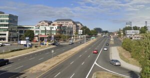
1) Reduce the design speed for all commercial arterial roadways (e.g., Richmond Highway, Sudley Road, Centreville Road, Dale Boulevard) to 35 MPH or less.  Speed kills.  If VDOT is willing to reduce the posted speed limit on parts of US-1 to 35 MPH in Fairfax County and to 25 MPH in Arlington County (with the local governing body’s concurrence), it will do the same in Prince William County.

2) Avoid and eliminate right-turn-only lanes on commercial arterial roadways, to shorten the crossing distance for pedestrians, lower vehicle speeds and improve yielding behavior at intersections, and reduce traffic crashes.

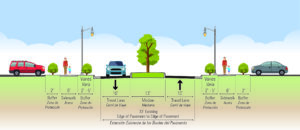
3) Eliminate overly wide (e.g., all 12-ft) travel lanes and excess roadway capacity through roadway reconfigurations (e.g., lane diets and road diets).   Wide and unwarranted travel lanes promote speeding and consume valuable public street space that could be reallocated to better accommodate non-vehicular travel modes and/or turning or parked vehicles.

 4) Establish a robust roadway reconfiguration program–in conjunction with scheduled VDOT roadway resurfacing projects–to retrofit bike lanes and pedestrian safety improvements, at little or no cost to Prince William County, through lane diets and road diets.   As Fairfax County DOT has accomplished for well over a decade, roadway reconfigurations during scheduled VDOT resurfacing projects can substantially and cost effectively expand a locality’s bikeway network and improve pedestrian comfort and safety.

5) Improve intersection safety for pedestrians, where warranted, by installing pedestrian crossing signals with Leading Pedestrian Intervals, high-visibility (and raised) crosswalks, and improved street lighting.  Reduce pedestrian crossing distances with lane reductions, bike lanes, pedestrian refuges, and/or curb extensions (aka bulb outs), and slow turning vehicles by reducing curb- return radii.

6) Add signalized pedestrian crossings of commercial arterials where the existing signalized crossings are too widely spaced.

7) Improve sidewalk safety and comfort for pedestrians and reduce mid-block traffic crashes by consolidating commercial driveway entrances and by installing raised medians during road reconstruction and rehabilitation projects.  Meanwhile, all existing driveway aprons on sidewalks should receive high-visibility crosswalk markings until such driveway aprons are eventually removed.

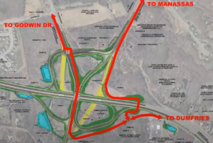
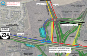
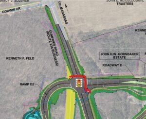
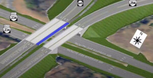
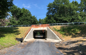
8) Grade separate all trail crossings of multilane roadways, especially as part of interchange construction projects.  Install raised crosswalks at at-grade sidewalk and trail crossings to enhance the visibility and reinforce the right-of-way of crosswalk users and to slow approaching traffic.

9) Ensure that all roadway crossings of streams are planned, designed, and effectively inventoried by VDOT to accommodate existing and future stream valley trails beneath the roadway or within the steam culvert.

10) Avoid and eliminate all at-grade sidewalk and trail crossings of multilane turn lanes or highway ramps, to preclude dual-threat or multi-threat crossing situations, where the drivers in every lane must stop for (or yield to) vulnerable road users and already-stopped vehicles may block the view of crossing pedestrians.

11) Install signs, pavement markings, and flashing beacons, as appropriate, to alert turning drivers to crossing vulnerable road users at free-flow right-turn lanes (aka slip lanes).

12) Ensure that all segments of US Bicycle Route 1 within Prince William County attain an acceptable Bicycle Level of Service (BLOS) of C or better, through roadway reconfigurations, route realignments, paved shoulder retrofits, and/or shared-use path construction or reconstruction, following up on this circa 2013 route evaluation.  The deficient route segments currently include Fleetwood Dr, Aden Rd, Joplin Rd, Bristow Rd, Hoadly Rd, Minnieville Rd, Old Bridge Rd, and Tanyard Hill Rd.

13) Establish Prince William County procedures for snow and ice removal from sidewalks and shared-use paths, especially along bus routes.  VDOT, by established policy, does not remove snow or ice from its sidewalks or shared-use paths, but after the roads have been cleared, sidewalks, paths, and bus stops may be blocked for many days and even weeks by mounds of plowed snow and ice, forcing pedestrians and bus riders to walk in the roadway.  Do Prince William County and its four towns have and enforce snow-removal ordinances?  Could volunteers be enlisted to adopt a road segment for snow clearing?  Are both the County and PWCS equipped and mandated to remove snow and ice on sidewalks and paths that front PWC- or PWCS-owned parcels?

14) Establish and enforce Prince William County procedures to ensure the maintenance of traffic (MOT) for people using sidewalks or shared-use paths during nearby construction projects.

15) Establish programs to identify, inspect, prioritize, and annually fund the construction, repair, replacement, and upgrade of sidewalks and shared-use paths, by the County and by VDOT.

16) Establish a program to identify, prioritize, fund, build, and maintain neighborhood cut-through paths that connect low-traffic subdivision streets.

17) Develop and promote a bicycle comfort level (level of traffic stress) map for Prince William County, building upon a previous effort.

18) Establish a PWC quick-build program to test road reconfiguration concepts in a cost-effective and timely manner.

19) Implement a strategic and data-driven program of automated traffic law enforcement to the fullest extent allowed by the Commonwealth of Virginia.

20) Continuously track and report annually on traffic crashes, injuries, and fatalities to identify their leading causes and locations and to monitor progress.

21) Develop a strategic and comprehensive active transportation master plan for Prince William County, guided by an expert team of outside consultants.

###

“Taming Our Arterials” Webinar, September 29 @ 7 PM

Multi-lane suburban arterial roads–such as Routes 1, 28, 123, and 234 Business in Prince William County– are dangerous and hostile for pedestrians and bicyclists.  How can we make these roads safer?  That’s the theme of this virtual panel discussion on Thursday, September 29, 2022 at 7 p.m., sponsored by our friends at the Fairfax Alliance for Better Bicycling, Toole Design Group, and the Coalition for Smarter Growth.

Register in advance on Zoom.

Andy Clarke of Toole Design Group, Fairfax County Lee District Supervisor Rodney Lusk, Stewart Schwartz of the Coalition for Smarter Growth, and Bill Cuttler of VDOT’s Northern Virginia Construction District will discuss long- and short-term methods that can be used to tame our big roads.  They will discuss some techniques that have been shown to work, and address how to overcome institutional barriers to making these changes.

Event Organizers

Metro DC’s Car Free Day, Thursday, September 22, 2022

Car Free Day Metro DC, organized by the Commuter Connections program of the Metropolitan Washington Council of Governments, is back this year on Thursday, September 22, 2022.

Use Transit, Carpool/Vanpool (Car-Lite), Bike, Scooter, Walk, or Telework

Take the pledge, even if you’re already car free.

Car Free Day is a worldwide event that encourages greener methods of travel; meaning ways to get around other than driving alone by car.  Commuter Connections hosts Car Free Day in the Washington, DC region to bring awareness to the many benefits of travel options such as transit, bicycling and walking; and also telework for people who can work from home. Carpooling and vanpooling count too; they’re considered “car-lite” since they are both lighter on the wallet and the environment than driving alone in a car.

Reduce your Carbon Footprint

Using more sustainable ways to get around helps reduce harmful greenhouse gas emissions and traffic congestion. The more people who travel using bicycles, buses, trains, carpools and vanpools, the fewer pollutants are released into the atmosphere.

CHOOSE THE TRAVEL METHOD
THAT FITS YOUR MOBILITY BEST

Take the Pledge!

All are welcome to take the Car Free Day pledge whether you’re a Washington DC area resident, commuter, or student.  Once you take the Online Pledge, you’ll be automatically entered into a raffle for all sorts of great prizes. Click any of the links above, and select the travel method that fits your mobility best!

Our Comments on the Mathis Avenue Improvement Project

On March 31, 2022, Active Prince William submitted the following comments to the City of Manassas regarding its proposed Mathis Avenue Improvement Project:


Re: Mathis Avenue Improvement Project (T-086) Public Meeting Comments

On behalf of Active Prince William, I’m writing to submit the following comments in response to the March 17, public meeting for the above-referenced project.  Our all-volunteer organization seeks improved active mobility and public transportation throughout greater Prince William, to create more livable, equitable, and sustainable communities.

An Improved Public Process for Transportation Project Development

We sincerely appreciate the improved process used to involve the public at the 30% design stage for this capital transportation project, which included both a February 23 virtual public meeting and an in-person meeting held on March 17.  This public involvement process is far better than the one used by City staff for its recent Sudley Road Third Lane Project, which excluded all public input before preliminary engineering was at least 90% complete (including when that project had been re-scoped substantially twice, in December 2017 and in February 2021).  We hope this public comment opportunity reflects a permanent policy change to proactively involve the public in all City transportation projects going forward, ideally starting at the project scoping stage.

The Proposed Design is a Reasonable Interim Aesthetic Improvement but Lacks Essential Pedestrian Amenities for a Vibrant, Mixed-Use Street

As a final condition for a revitalized Mathis Avenue as a mixed-use, pedestrian-oriented street–ideally with robust bus transit service–the proposed design would be a major disappointment.  However, as an interim improvement intended to transform the appearance of this somewhat desolate commercial street and to promote future mixed-use redevelopment at minimal cost, this project does appear to have merit.

In particular, the proposed design provides sidewalks that are too narrow for comfortable two-way walking, are too close to the roadway, and lack street trees and pedestrian-serving street furniture in what should be much wider curbside planting strips and furniture zones.   In addition, the sidewalks are interrupted with frequent curb cuts, where motor vehicle cross flows impede safe and comfortable walking.

However, considering the need for Mathis Avenue to continue serving the existing auto-oriented businesses beside it, especially along the east side of this street, until redevelopment occurs some years in the future, the imperative to minimize right of way takings and to preserve the existing curb cuts is understandable.

To effectively promote the specific forms of redevelopment that the City seeks and to ensure that this redevelopment incorporates the necessary mobility infrastructure to equitably support that redevelopment, the City’s Department of Planning and Community Development should undertake a robust community-based planning process to develop a detailed form-based zoning code for the Mathis Avenue corridor.  Form-base zoning codes are a proven tool to effectively promote the specific forms of redevelopment desired by localities.

Bicycling Accommodations and Roadway Design Speed

The lack of bike lanes (or any alternative bicycle facilities) in this project is disappointing but is also understandable since the existing curbs are not being moved to keep the existing storm sewer infrastructure in place, to minimize costs and commercial property impacts.  However, without bike lanes, the construction of raised medians will degrade bicycling conditions substantially, and those degraded conditions are unlikely to be remedied by a future roadway widening when the corridor is eventually redeveloped.

Presently, motorists can readily safely overtake people riding bicycles on Mathis Avenue by passing in the two-way central left-turn lane.  The raised medians, however, will prevent motorists from overtaking bicycle riders, who typically travel at 10-16 MPH.  Thus, people riding bicycles on Mathis Avenue will serve as slow-moving traffic-calming devices.  This roadway change will make bicycling unpleasant for nearly all riders and will subject people riding bicycles to increased harassment from frustrated motorists who are unable to pass.  Moreover, since Mathis Avenue would probably not be rebuilt with added bike lanes when redevelopment occurs in the future, this degradation of bicycling conditions on Mathis Avenue is likely permanent.

The fact that nearby Portner Avenue is designated as a bicycle route is no reason to degrade bicycling conditions on Mathis Avenue.  While many through bicyclists already prefer to travel on Portner Avenue, only Mathis Avenue serves the businesses and jobs located along Mathis Avenue, and people will someday live on this segment of Mathis Avenue too.

Thus, for both bicycle access and pedestrian safety, this project should strive to reduce the design speed for Mathis Avenue–and ideally the posted speed limit–to 20 MPH or below.   The raised median with street trees—and especially street trees in future curbside planting strips and future taller buildings closer to the roadway—should encourage motorists to drive more slowly on Mathis Avenue, but other design changes are needed too.

Shorter curb-return radii at corners and narrower sidewalk curb cuts would help reduce motor vehicle speeds, and electronic speed-feedback signs paired with posted speed limit signs (dynamic speed displays) would warn speeding motorists to slow down.  In addition, shared-lane markings (aka “sharrows”) centered in each travel lane would inform both motorists and bicycle riders that this is a shared roadway.

More Visible and Shorter Crosswalks

One notable design feature that should be changed is the proposed use of brick-colored stamped asphalt crosswalks.  While intended to impart historic charm, brown-colored crosswalks are far less conspicuous to motorists than modern high-visibility and reflective thermoplastic crosswalk markings.  The primary purpose of marked crosswalks is to alert motorists to the likely presence of crossing pedestrians, encouraging drivers to slow down, look for, prepare to yield to, and stop for pedestrians who may be crossing the roadway.  A faux-brick aesthetic is far less important than the safety of people who are walking across the street.

In addition, the final design of each intersection should pay particular attention to shortening the length of all crosswalks to the extent feasible and to install two separate curb ramps for the crosswalk landings at each corner.  The present design includes a single combined curb ramp at the southeast corner of Mathis Avenue and Sudley Road and at all four corners of Mathis Avenue and Liberia Avenue, the two on the north side not being rebuilt.

Designing shorter curb-return radii at all intersection corners, as suggested above to reduce the roadway design speed, would also reduce the crosswalk lengths at those intersections.

Consider Short Left-Turn Lanes at Reb Yank Drive and Carriage Lane

The advertised design does not include any space in the center of the roadway (beyond the intersection itself) to store vehicles waiting to turn left at Reb Yank Drive (from both directions) or southbound at Carriage Lane.  While shortening the raised medians to add short left-turn pockets at those three locations could increase travel speeds along Mathis Avenue and could also remove the proposed median refuges for crossing pedestrians at those unsignalized intersections, it may be prudent to add those left-turn pockets to smooth traffic flow, reduce traffic congestion, and lower the incidence of rear-end collisions at those locations.  However, if traffic studies have already documented that those left-turn pockets are unnecessary, then please retain them.

Thank you for considering our comments as you finalize the design of this project.

While Better, the Revised Design of the Route 234-Brentsville Road Interchange in Still Badly Flawed

Prince William County DOT’s currently proposed circuitous trail routing through the Interchange, assuming that a direct trail bridge connecting the existing Route 294 and Route 234 Trails is included in this project

Our proposed trail connections through the planned interchange to reach Route 234 Business (red line) and the future trail along the Route 234 Bypass (blue line).  A trail (red line) running along the north side of Route 234 would pass underneath both new roadway overpasses. The three light blue circles show where box culverts could allow the trail to be routed beneath highway ramps.  The areas shown in yellow are existing roadways that are planned to be removed.  This design eliminates all at-grade trail-roadway crossings, except to reach Route 234 Business.  However, by building a shared-use path along the west side of Route 234 Business (connecting to Godwin Dr), trail users would be required to cross only 5-lanes of stopped traffic at just the western leg of the signalized intersection of Bradley Cemetery Way and Route 234 Business, not 12-lanes of stopped traffic plus one lane of free-flowing right-turning traffic at two separate legs of that intersection.

This post follows up on the comments we previously submitted in response to the December 8, 2021 Design Public Hearing for Prince William County DOT’s Route 234-Brentsville Road Interchange Project.

On March 18, 2022, the County released this followup video presentation on the proposed project design.   County DOT staff are willing to at least partly addresses three concerns with the proposed trail connections that were raised at the Design Public Hearing:

1) In response to public comments from Active Prince William and others, the County is now studying the cost feasibility of a new, dedicated trail bridge over Rte 234, just east of the interchange, to directly connect the existing trails along Route 234 and Route 294.   If this trail bridge can be added without the project exceeding it’s $55 million budget, it will be included in this project.   Otherwise, it probably won’t.

2) In response to safety concerns raised by many about the four proposed closely spaced at-grade trail crossings of free-flowing highway ramps near Route 294 and Bradley Cemetery Way in the northeast corner of this project, those hazardous at-grade trail crossings may not be built, at least if the added trail bridge discussed above is actually built.    However, this change would produce a long, circuitous trail route between the western legs (Route 234 Bypass and Route 234 Business) and eastern legs (the existing trails along Routes 234 and 294) of this interchange (shown in the top image above).

3) In response to objections that the design completely omits the long-planned trail along the Route 234 Bypass that should join the existing trails along Route 234 and Route 294,  the design team has identified a future location for this trail along the northwestern edge of the interchange (see the blue line in the second image above).

However, all trail connections to and from Route 234 Business and the long-planned future trail along the Route 234 Bypass (aka Route 234 North) would still require a two-stage at-grade crossing of 12 signalized traffic lanes plus one free-flowing right-turn lane at the rebuilt intersection of Bradley Cemetery Way and Rte 234 Business plus a second at-grade trail crossing of a free-flowing highway ramp at the south side of the interchange (at the on-ramp from Brentsville Road) .  Those remaining design flaws would still create considerable delays and hazards for trail users.

Under Prince William DOT’s revised design for this interchange, this slow and hazardous crossing of 13 traffic lanes at two legs of the signalized intersection of Bradley Cemetery Way and Route 234 Business would remain.  All trail access and egress from either Route 234 Business or the future trail along the Route 234 Bypass would need to use this routing to join either of the existing trails along Route 234 and Route 294 or Brentsville Road.

As a followup proposal, we suggest routing the long-planned trail along the Route 234 Bypass along the north side of Route 234 (per the second image from the top), connecting that trail to both the existing Route 294 Trail to the east and to a new shared-use path along the west side of Route 234 Business (where the existing pavement, depicted in yellow, is planned for removal).   This trail (depicted with a red line in that image) would pass underneath both new roadway overpasses being built to carry Brentsville Road and Route 294 over Route 234 and could also pass underneath three single-lane interchange ramps inside box culverts (see the light blue circles).

Under our proposal, the long-planned trail along the Route 234 Bypass would run along the north side of Route 234 and pass under both planned roadway bridges.


Three short box culverts could be used to route our proposed trail along the north side of the Route 234 Bypass beneath three one-lane interchange ramps.  Only one such box culvert would be needed for the connection to Route 234 Business.

Our proposed design eliminates all at-grade trail-roadway crossings, except to reach Route 234 Business.  However, by building a shared-use path along the west side of Route 234 Business (connecting to Godwin Dr), where only a sidewalk is currently planned, trail users would be required to cross only 5-lanes of stopped traffic at just the western leg of the signalized intersection of Bradley Cemetery Way and Route 234 Business, not 12-lanes of stopped traffic plus one lane of free-flowing right-turning traffic at two separate legs of that intersection.

Our proposal could also lower the cost of this project by eliminating the need to include a 14-foot wide shared-use path on the proposed Brentsville Road bridge.

Active Prince William believes that first-class, safe and direct trail connections for all five legs of this interchange can and should be provided within this project’s existing budget of $55 million.

« Older posts