Advancing active mobility in greater Prince William, Virginia

Category: Bike Trails (Page 3 of 6)

Active Prince William’s Initial Comments on the Proposed Design of the Route 234-Brentsville Road Interchange

 
PROBLEM:
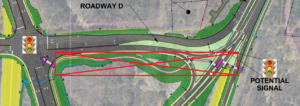
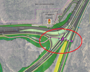
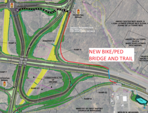
Forcing bicycle and pedestrian users to cross FOUR separate free-flowing, high-speed vehicle lanes is an unacceptable way to connect two of the major trails in the county.  The section should be removed from the design.  It is too dangerous.  [Added Note: The proposed design forces bicyclists and pedestrians to negotiate a fifth high-speed at-grade road crossing (of the ramp from northbound Brentsville Road to southbound Route 234) to actually link these two major trails.  Furthermore, to access or egress Route 234 Business/Dumfries Rd, bicyclists and pedestrians would be forced to negotiate a sixth high-speed at-grade road crossing plus 12 vehicle lanes at two controlled intersection legs at Bradley Cemetery Way.]


RECOMMENDED SOLUTION:
Add an additional bike/ped bridge crossing of Route 234 south/east of the planned interchange to directly and safely connect the Route 234 Trail and the Prince William Parkway Trail.


HOW TO PAY FOR THIS RECOMMENDED SOLUTION:
1) Remove the proposed bike/ped infrastructure with four at-grade roadway crossings from the Bradley Cemetery Way area:

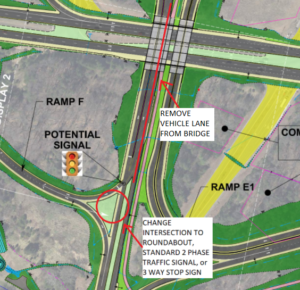
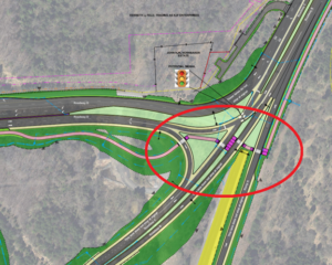
2) Change the Continuous Green-T Intersection at Brentsville Road and the off-ramp from VA234 Bypass South to a Roundabout, Standard Two-Phase Traffic Light or a Three-Way Stop Sign.  Future traffic volumes do not warrant the expensive infrastructure needed for a Continuous Green-T Intersection.

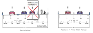
3)  Remove one northbound lane from the planned Brentsville Road Bridge to create a smaller/cheaper bridge footprint.  Future traffic volumes do not warrant having two northbound vehicle lanes on this bridge.

Design Public Hearing for PWC’s Route 234-Brentsville Road Interchange Project, December 8, 2021 at 6:00 PM

Prince William County’s proposed Route 234-Brentsville Road Interchange includes four treacherous at-grade shared-use path crossings of free-flowing high-speed roadways to link the Prince William Parkway and Route 234 sidepaths.   As an alternative to this dangerous and circuitous trail routing, Active Prince William advocates a simple trail overpass on the east/south side of this interchange to safely and directly link Prince William County’s two major trails.


From the Office of Coles District Supervisor Vesli Vega:

A public hearing on the proposed Brentsville Interchange Project will be held on Wednesday, December 8th at 6pm at the Lake Jackson Volunteer Fire Department, 11310 Coles Drive in Manassas.

The meeting can also be viewed live online at https://www.pwcva.gov/department/transportation/current-road-projects.  The Project team will make a short presentation beginning at 6:30 p.m. and answer questions for the duration of the meeting.

The purpose of the public hearing is to receive public comments on the design of the Route 234 Brentsville Road Interchange Project and associated Limited Access Control Changes in the Coles Magisterial District.  This Project will involve a change and break in Limited Access Control.

Preview the Project information and Design Public Hearing plans including the environmental documentation on the Prince William County Department of Transportation website at https://www.pwcva.gov/department/transportation/current-road-projects.  [Note: The five linked documents related to the current design are listed at the bottom, with links depicted in green.  The blue links are for the obsolete March 2020 design].

The deadline to submit comments is December 18, 2021.  The public may provide written or verbal comments at the Design Public Hearings, mail them to Ms. Mary Ankers, P.E., Project Manager, at the Prince William County Department of Transportation, 5 County Complex, Suite 290, Prince William, VA 22192, or email them to mankers@pwcgov.org.   Please reference “Route 234 Brentsville Road Interchange Project PH Comments” in the subject heading.

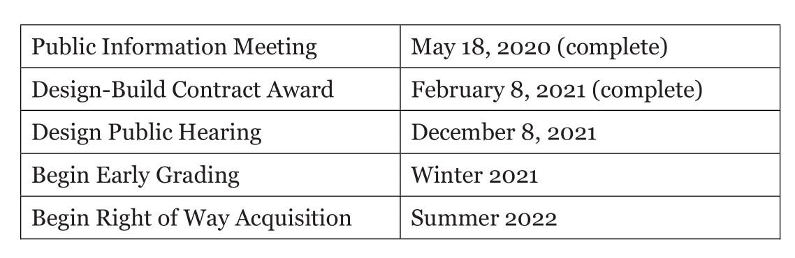
Please find the Project Schedule Below:

Our General Comments on Active Mobility and Trails for the Mobility Chapter in the PWC Comp Plan Update

On June 16, 2021, Active Prince William submitted the following general comments on the active mobility and trails element for the Mobility Chapter in Prince William County’s Pathways to 2040 Comprehensive Plan:


Active Prince William’s General Comments on the Active Mobility and Trails Element of the Mobility Chapter in Prince William County’s Pathways to 2040 Comprehensive Plan

1. Active Prince William encourages Prince William County to plan for the expeditious development of a robust, connected, and diverse countywide network of bikeways, walkways, and trails as part of the Mobility Chapter of the Pathways to 2040 Comprehensive Plan.

2. The County should invest in building more “active transportation” infrastructure through 2040 to rebalance the excessive car-centric focus of the past.  A robust, countywide Bicycle and Pedestrian Mobility Plan should be created to identify and prioritize bikeways and walkways that connect all activity centers and provide safe routes to all schools, parks, recreation centers, libraries, transit hubs, shopping centers, and employment sites, so bicycling, walking, and rolling can increasingly replace many short-distance (under 5-mile) motoring trips

3. The Bicycle and Pedestrian Mobility Plan should identify where various types of bikeways, trails, and sidewalks will be completed by 2040.  One goal, synchronized with the Parks, Recreation and Tourism Chapter and the Systemwide Master Plan for county parks, should be to create a connected network of shared-use paths, sidewalks, and bikeways, so all neighborhoods with a density of 4 or more dwelling units/acre are within a 10-minute walk (1/2 mile) of a neighborhood park or school/community-use site.

4. The County should establish a more vigorous and ongoing Active Transportation Program within its Department of Transportation, guided by a comprehensive and strategic Bicycle and Pedestrian Mobility Plan adopted by the Board of County Supervisors. The development of that plan, which could require a year or more of effort and community outreach, should be guided by dedicated in-house transportation planning staff and a diverse citizen task force. An outside consulting firm with strong expertise in active mobility planning (e.g., Toole Design Group or Alta Planning + Design) should be hired to coordinate the development of this Bicycle and Pedestrian Mobility Plan.

5. Formal Complete Streets and Vision Zero policies and action plans–adopted by the Board of County Supervisors following substantial public input–could help guide the County’s development of active mobility infrastructure.

6. The Mobility Chapter should include a table listing specific planned bicycle, pedestrian, and trail facilities, comparable to Table 2 listing the Thoroughfare Plan projects.

7. Appropriate bicycle and pedestrian accommodations should be planned and aggressively implemented, both as an integral component of all roadway widening and reconstruction projects and as standalone projects actively pursued separately from roadway reconstruction, during both scheduled roadway resurfacing and as fully independent projects.

8. A strategic prioritization process should guide the implementation of the standalone bicycle and pedestrian projects. The prioritization process for standalone projects and retrofits should consider many factors, with “opportunity” (such as upcoming roadway resurfacing, grant availability), trip demand, cost effectiveness, equity, and pedestrian safety being key considerations.

9. Bicycling accommodations for collector and arterial road corridors and urban boulevards should not be largely limited to shared-use paths (sidepaths), which are often hillier, more meandering, and less well maintained than the adjacent roadway and frequently interrupted by hazardous motor vehicle cross flows at intersections and driveways. These features make sidepaths much slower and more stressful for bicycling than simply sharing the roadway with vehicular traffic.

10. Whenever feasible, dual bicycling accommodations–both off-roadway (sidepath) and on-roadway (bike lanes, separated bike lanes, paved shoulders, or signed shared roadways)–should be provided to serve the diversity of people who ride bicycles.

11. Roads with Average Annual Daily Traffic (AADT) less than 1,000 vehicles/day generally require no special accommodations for bicycling enthusiasts.

12. Adding paved shoulders (on open-section roadways) or bike lanes (on closed-section roadways with curb and gutter) is appropriate for road cycling enthusiasts and can provide very suitable bicycle accommodations, particularly in the Rural Area.  As traffic speeds and/or volumes increase—and for roads along a designated bike route– the need for (or desirability of) wider paved shoulders or bike lanes or for more separation between the bike lane and the adjacent travel lane (with either a crosshatched buffer or a physical barrier) increases.

13. The Mobility Chapter should include a policy that when the traffic volumes on roads in the Rural Area rise above 1,000 vehicles/day, VDOT will be asked to retrofit modest (2- to 4-foot wider) paved shoulders during scheduled roadway resurfacing, retaining the original 30-foot prescriptive easement. Such modestly widened roadways could then be striped with two 10-foot travel lanes flanked by two 5-foot paved shoulders for walking and bicycling.

14. When any residential development involving 10 or more homes is permitted beside a road without a sidewalk, the developer should be required to build a sidewalk or a sidepath along the road frontage for that subdivision.

15. On roadways where traffic volumes are forecast to exceed 10,000 vehicles/day over the next 20 years, adding a central two-way left-turn lane as well as paved shoulders or bike lanes should be proposed, as an alternative to widening to four or more travel lanes.

16. Roads planned for “Class II” bikeways should be identified as planned for “sidewalks plus bike lanes,” or just for paved shoulders or bike lanes.

17. The current designation for 14-foot “wide” outside lanes (termed “Class III” bikeways) should be eliminated. All of those roads should be re-designated for bike lanes (aka “Class II” bikeways). If multilane roads are simply striped with 11-foot travel lanes instead of the Interstate-regulation 12-foot travel lanes, a 14-foot outside lane becomes at least 16 feet wide, which is wide enough to allocate as a 5-foot wide bike lane plus an 11-foot travel lane.  Thus, the category of “wide outside lanes” is not only a poor bicycling accommodation; it’s a completely unnecessary category.

18. Signed shared roadways (e.g., relatively low-speed collector roads with shared-lane markings (a.k.a. “sharrows”) or low-traffic residential subdivision streets with way-finding signs) are the only “Class III bikeways” that should remain.

19. Signed shared roadways should be planned only where traffic speeds and volumes are relatively low, and bike lanes are either infeasible or unnecessary due to low traffic speeds and volumes.  This category should be designated as “Sidewalks and Shared Roadways”, rather than as “On-Road Trails.”

20. The Vision Zero strategies appropriate for different areas in Prince William should be identified and incorporated in all transportation planning.  Crashes involving a vehicle with a bike or pedestrian should be reported as a “vehicle-bike crash” or “vehicle-pedestrian” crash, not as “bike crash” or “pedestrian crash”.  Since vehicle speed greatly influences the severity of such crashes, VDOT and the County Department of Transportation should seek to lower the design speeds and posted speed limits on roads within activity centers, and emerging technologies, such as automated speed enforcement, should be used to reduce speeding. Particular attention should also be paid to minimizing risk when designing intersections that permit right turns on red and intersections where people walking or bicycling must cross two or more lanes of free-flow traffic.

21. Since transportation is our largest source of greenhouse gas emissions, and Prince William has committed to reduce these emissions by 2030 to 50% of the 2005 level, the County should quantify the greenhouse gas emission impacts of proposed new transportation projects, including trails, for the county’s Climate Action Plan.

22. For shared-use paths, bike lanes, and sidewalks maintained by the county, rather than VDOT or an HOA, the PW County Departments of Transportation and of Parks, Recreation and Tourism should budget annually for routine maintenance as well as for capital maintenance (e.g., periodic repaving).  That includes removing storm debris, managing winter snow and ice, mowing grass, and removing encroaching vegetation.

23. For Traffic Impact Analyses, the county should report average pedestrian delay at intersections together with reports of average vehicle delay, and calculate bicycle and pedestrian Levels of Service and/or Comfort, comparable to calculating Level of Service for Vehicles.  Intersections should be designed to balance delays for bicyclists/pedestrians as well as delays for vehicles.
City of Manassas Transportation Project Virtual Public Meetings, May 18, 20, and 25

During May 2021, the City of Manassas held three virtual public meetings on various transportation projects:

1) Tuesday, May 18 @ 7 pm–virtual public meeting on the Sudley Road Third Lane project . View the project design presentation on the Sudley Road Third Lane Project from the May 18 meeting.

2)  Thursday, May 20 @ 7pm–virtual public meeting on four sidepath projects (Godwin Dr, Dumfries Rd, Gateway Blvd, and Wellington Rd trail gap) and three sidewalk projects (Portner Ave, Quarry St, and Gateway Blvd).  View the meeting presentation and a 31-minute recording of the Zoom meeting.

3) Tuesday, May 25 @ 7pm–virtual public meeting on the Dean Drive Extension ProjectView the project design presentation on the Dean Drive Extension Project.

City of Manassas Installs Dangerous and Unnecessary Trail Bollards

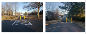
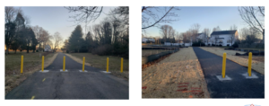
March 15, 2021 Update:  We have  been informed by the City’s Director of Public Works that many of the bollards shown below have been removed.  The City is now installing a single rigid bollard on the trail centerline, with additional bollards placed six feet apart at some locations.  In addition, reflective tape will be installed near the top and the bottom of each bollard.  While these changes significantly reduce the severity of the trail-bollard hazard, the users of these paths will still remain at some risk for serious and permanently debilitating and even fatal injuries from crashing into the remaining bollards.  We urge all public agencies to heed the AASHTO guidance and FHWA recommendation (both cited below) to end the routine use of even single rigid bollards as its default design treatment to discourage motor vehicle incursions on shared-use paths.

July 2023 Update:  The City of Manassas has finally replaced the former rigid black steel bollards at both entrances to its Winters Branch Trail with white plastic flexible posts with silver reflective tape!   Thank you!!!

Active Prince William board member Allen Muchnick, a City of Manassas resident, sent the following notice to multiple City of Manassas officials on February 7, 2021:


I was pleased to see the lead article in the January 2021 issue of City Connection newsletter, featuring several newly built asphalt shared-use paths around Manassas.  I commend City staff for working inter-departmentally to quickly fund, design, and build these valuable neighborhood connections.

However, my initial joy over these new connections was soon marred by disappointment and dread upon seeing the four photos of dangerous, unnecessary, and closely placed rigid trail bollards on Slides 20 and 21 of the Manassas Public Works annual report.

While intended to prevent both intentional and accidental intrusions by motor vehicles–and occasionally needed to prevent costly damage to fragile infrastructure, such as foot bridges–hard, rigid bollards installed within the traveled way of shared-use paths have been widely recognized for decades as a substantial hazard for people riding bicycles, causing many severe and permanent injuries and even deaths.   An extensive bicyclist critique of trail bollards is posted here.

For that reason, nationally recognized guidance for the design and construction of shared-use paths have long cautioned against installing hard, rigid bollards on shared-use paths.   A variety of simple and cost-effective alternative design treatments—starting with signs prohibiting entry by motor vehicles—are quite effective at preventing motor vehicle intrusions and vastly safer than trail bollards.

Although NOVA Parks’ 45-mile Washington and Old Dominion (W&OD) Trail includes scores of at-grade road crossings, NOVA Parks removed all of its former bollards and fences along that trail more than 20 years ago, in recognition of the significant danger that such obstructions pose to trail users.  NOVA Parks has not seen any need to reinstall trail bollards since.

Where the risks and consequences of unwanted motor vehicle entry is significant and demonstrated, trail bollards should be installed only on the centerline of two-way shared-use paths, and flexible bollards should be used if feasible.  If multiple bollards must be used, they should be used in sets of three (never two or four, to reduce head-on collisions) and spaced at least five feet apart to allow safe passage by bicycle trailers.

The Federal Highway Administration has long warned against installing bollards on recreational trails.  The first bullet point states:  “Even “properly” installed bollards constitute a serious and potentially fatal safety hazard to unwary trail users. In addition, no bollard layout that admits bicycles, tricycles, and bicycle trailers can exclude single-track motor vehicles such as motorcycles and mopeds. For these reasons, bollards should never be a default treatment, and should not be used unless there is a documented history of intrusion by unauthorized cars, trucks, or other unauthorized vehicles.”

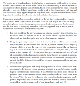
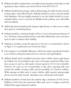
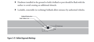
Similarly, the AASHTO Guide for the Development of Bicycle Facilities (4th Edition, 2012) contains extensive guidance on trail bollards on pages 5-46 and 5-47, including these paragraphs:

Since the above-referenced newly installed trail bollards are a well-recognized defective and unreasonably dangerous property condition for people riding bicycles, scooters, skate boards, and other devices, I ask that these trail bollards be removed immediately from the paths at Kinsley Mill Park, Tudor Lane, Oakenshaw Park, and Bartow Street and that none be installed along the still-unfinished path along the southern perimeter of the Metz Middle School property.

I’m confident the City of Manassas would never install a rigid bollard within a few feet of any vehicular travel lane, although such obstructions would mostly endanger vehicle exteriors, not human bodies.  So, how can it be considered acceptable to expose non-encapsulated people traveling on balanced bicycles (or simply walking) to such dangerous obstructions?

###

« Older posts Newer posts »