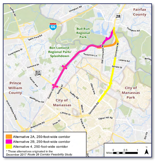
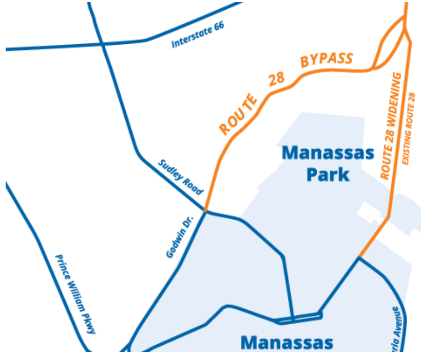
Active Prince William applauds the Prince William Board of County Supervisors (BOCS) for rejecting the Route 28 2B alignment on August 4 (see Agenda Item #10B, starting at 4:18 on the recorded video). We further agree that doing nothing to fix Route 28 through Yorkshire is not an option; however, widening Centreville Road itself by adding two general-purpose travel lanes would disrupt many businesses.
VDOT’s Centreville Road (Route 28) STARS (Strategic Targeted Affordable Roadway Solutions) Study, championed by Delegate Roem, recently recommended a $38 million package of intersection, raised median, and pedestrian improvements that–in the absence of general roadway widening–1) would significantly reduce intersection delays and expand vehicle capacity and pedestrian access along Route 28 and 2) was ripe to receive VDOT SMART SCALE funding for design and construction in spring 2021.
Unfortunately, proceeding with widening Route 28 itself through Yorkshire could make the sensible and cost-effective STARS Study recommendations infeasible. Therefore, we encourage the BOCS to explore an alternative approach, integrated with a new land-use plan (Small Area Plan) for economic development and revitalization along this corridor. Alternative 4 could be modified to include a new multimodal street just to the west, so highway investment could stimulate transit-oriented, mixed-use redevelopment of the properties between and fronting the existing and future sections of Centreville Road. Integrated planning could foster the creation of a vibrant new livable community with affordable housing at a key gateway to Prince William County.
Route 28 Alternatives Studied in the 2018-2020 Environmental Assessment
Prince William County (PWC) needs a Department of Mobility, not a Department of Highway Paving. Since the Shirley Highway reached the Occoquan River in 1949, we have paved and paved, at great expense to the environment and taxpayers. Has traffic congestion been eliminated? The answer to this is ‘no’. Expanding highways is not the answer to creating livable communities with sustainable transportation.
Under the last Board of County Supervisors, the scheme was to keep building new roads and widening old roads. Everyone knew it would not “fix” the highways, but land speculators could get rezonings for building new subdivisions if the county would plan to pave more roads. Expanding roads will not solve congestion; that is a lesson learned from several decades of previous road projects in the region and across the country. However, if the county’s land use planning remains isolated from transportation planning, we will just keep repeating the old mistake. A citizen-led Multi-Modal Transportation Advisory Commission, similar to those in Fairfax and Arlington Counties and the City of Alexandria, could increase transparency and citizen involvement in determining how PWC will grow and its residents, workers, and visitors will travel.
So, what is Plan B, if “build roads, build new houses, create new congestion, build roads, build new houses…” does not work? The County’s Strategic Plan is clear – build live-work-play communities that locate housing together with stores and offices, so people can walk, and bike, more rather than drive everywhere for daily living. Invest in increasing the number of jobs within Prince William, rather than fund more roads that incentivize long commutes. We need smart growth planning.
Sadly, on August 4 the supervisors are considering a proposal that would repeat the mistakes of the past. They could approve Alignment 2B of the Route 28 Bypass/Godwin Drive Extension, to build a new commuter highway through the flood-prone Flat Branch stream valley. At least fifty-four homes would be destroyed, and many more would be degraded by increased traffic noise and air pollution.
A community with affordable housing, including a trailer park, would be disrupted so commuters from Fauquier and other counties can temporarily drive a bit faster through PWC. Over six acres of wetlands would be filled in, impacting the natural environment and resilience to climate change. A noise wall would be constructed from Sudley Road to Bull Run, blocking all potential bike/pedestrian access across the highway barrier except at a Lomond Drive intersection.
The traffic analysis report (check the tables on pp. 23-24, and p. 40 for Godwin Dr and for Rte 28 in Fairfax County) indicates that the Alternative 2B commuter Bypass road would create clogged, “failing” intersections on existing Godwin Drive, at all four new Godwin Dr Extension intersections, and along Centreville Rd in Fairfax County (between the north end of the Bypass and I-66). If this Bypass is approved, a future “Fix Godwin Drive” campaign will require even more funding – hundreds of millions for more highway paving. New flyover ramps might have to be added to the interchange of Route 28 and Prince William Parkway/Route 234 Bypass, and Godwin Dr between Nokesville Road and Sudley Road would need widening and intersection improvements . This is not a smart growth approach.
Residents of Prince William County need a government that uses smart growth principles to guide future land use and transportation decisions. Prince William County residents want livable communities that are great places to work, live, play, and raise a family. Prince William County residents want a sustainable environment that provides a resilient approach to the effects of climate change.
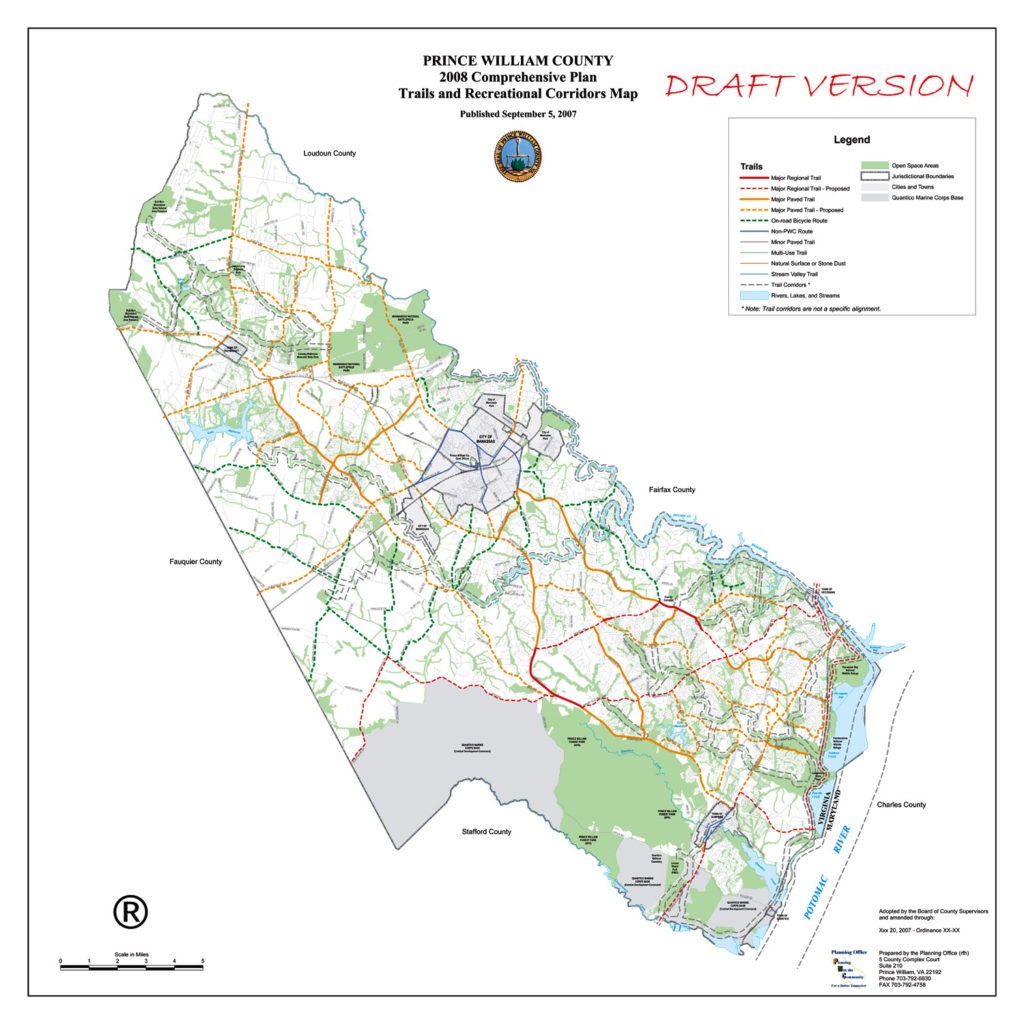
Proposed Prince William County Trails Network from 2007
1) Establish Citizen Transportation Advisory Commissions for Prince William County, Manassas, and Manassas Park.
2) Provide
Meaningful and Robust Public Participation Processes for the Coming
Comprehensive Plan Updates for the County and Cities.
3) Expand and Enhance Public Transportation as an Effective Travel Choice:
a) Add midday, evening, and reverse-commute VRE trips, possibly as shortened runs to/from Alexandria and/or Springfield/Franconia.
b) Add local and commuter bus service along Rte 28 and Sudley Rd, ideally in dedicated lanes.
c) Extend Richmond Hwy BRT south through Prince William County along the Rte 1 corridor to Quantico.
4) Build Complete Streets, especially a Primary Bikeway Network that Crosses Major Barriers (e.g., rivers, freeways, land parcels):
a) Build a continuous “I-66 Trail”, largely along Balls Ford Rd and across Bull Run into Fairfax County.
b) Build a quality bike/ped crossing of I-66 at or near Sudley Rd/Bus 234. In short term, ensure space for paths beneath all new I-66 overpasses of Sudley Rd.
c) Retrofit quality bike/ped crossings of I-95, especially at/near Prince Wm Pkwy/Horner Rd and at/near Dale Blvd/Opitz Blvd, but also at/near Rte 123, 234, & Joplin Rd.
d) Complete a continuous trail along Rte 234, from Rte 1 to I-66, including the totally missing segment between Brentsville Rd and I-66.
e) Include quality bike/ped access along and across Flat Branch and Bull Run in the proposed Godwin Dr Extension (Rte 28 environmental assessment).
f) Improve US Bike Route 1, a Maine-to Florida bikeway: Retrofit paved shoulders along Aden Rd (Joplin Rd to Fleetwood Dr) and Fleetwood Dr (Aden Rd to Fauquier line), fix the Hoadly Rd bike lanes, and sign all of USBR1 in PWC. Plan and create a paved shared-use path along the perimeter of Quantico Marine Corps Base as a long-term project.
g) Improve bike/ped crossings of Bull Run and the Occoquan River, including at Old Centreville Rd/Ordway Rd, Rte 28, Yates Ford Rd, I-66 Trail (connect Balls Ford Rd to Bull Run Dr), and Rte 1.
h) Improve bike/ped access along the Rte 29 corridor (Bull Run to Fauquier line).
i) Establish continuous ped/bike access along Old Bridge Rd.
j) Plan and develop a bikeway and trail network in Manassas Park.
5)Develop
Livable, Walkable, and Vibrant Transit-Oriented Communities:
a) Plan to revive aging suburban retail corridors and malls for higher-density, mixed-use, bus-transit-oriented redevelopment (e.g., Manassas Mall and the Sudley Rd corridor, Rte 28 in Yorkshire, Rte 1, Dale Blvd, Old Bridge Rd).
b) Remove or scale back all or part of numerous proposed road widenings from the Comprehensive Plan, including Brady’s Hill Rd, Carver Rd, Catharpin Rd, Dale Blvd, Dumfries Rd, Farm Creek Dr, Featherstone Rd, Gideon Dr, Godwin Dr Extension, Gordon Blvd, Groveton Rd, Gum Springs Rd, Horner Rd, Lucasville Rd, Manassas Battlefield Bypass, Neabsco Rd, Old Centreville Rd, PW Pkwy, Signal Hill Rd, Station Rd, Sudley Manor Dr, Sudley Rd, Rte 15, Rte 29, Rte 55, and Wellington Rd.
c) Innovation Town Center: Plan and develop a robust pedestrian and bicycle network, including a high-quality connection to the north side of the expanded Broad Run VRE Station.
6)Operate a Vibrant Safe Routes to School Program:
a) All new public schools, including the 13th high school, should be walkable and bikeable and include quality bicycle parking accommodations.
7)Make
Walking and Bicycling Safer:
a) Improve pedestrian crossings of multilane arterials (e.g., add missing pedestrian crossing signals, Leading Pedestrian Intervals, conspicuously marked crosswalks, sidewalk bulb outs, and/or streetlights; remove Right-Turn-Only Lanes).
b) Retrofit missing sidewalks along arterial roadways and on walk routes to schools and transit.
c) Provide a signed detour when pedestrian or bicycle facilities are closed for construction or maintenance activities.
8)Build a Comprehensive Recreational Trails Network:
a) Complete the East Coast Greenway/Potomac Heritage National Scenic Trail shared-use path through PWC, generally between Rte 1 and the Potomac River.
9)Improve
VRE Bicycle Access:
a) Provide covered bicycle parking and rental bicycle storage lockers at every VRE station in Prince William County, Manassas, and Manassas Park.
b) Improve bike/ped connections to VRE stations from all directions, including the expanded Broad Run station (including the Broad Run Trail), to improve bike/ped access to VRE from Bristow, the Landing at Cannon Branch, and Innovation Town Center.
c) Expand VRE bike-on-rail access (long capped at 34 bikes on 17 daily trains).
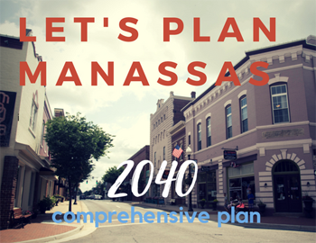
Using an 18-month process, the City of Manassas will update its Comprehensive Plan–the City’s key policy document for land use, development, preservation and related economic and social issues. As part of that update, the City will also develop its first Transportation Master Plan to guide future transportation investments and improve mobility in the City. This is an exciting time for City residents as the Manassas community envisions its future!
Citizen input in updating the Comprehensive Plan is vital to a more livable Manassas. Throughout the summer and fall, the City will host a second round of Community Conversations on key topic areas, like land use and transportation. These conversations began on June 19th with a visioning session on land use. Additional meetings are scheduled throughout the summer and fall. City Staff will also be available to meet with neighborhood and community organizations to gather feedback. Please contact 703-257-8223 for more information about hosting a meeting.
Upcoming Meetings
Parks & Recreation Community Conversation hosted by the Parks & Recreation Committee
Wednesday, July 11th – 7 PM @ Manassas Museum, 9101 Prince William Street
Community Appearance & Environment Community Conversation hosted by the Manassas Beautification Committee
Thursday, July 19th – 7 PM @ Public Works, 8500 Public Works Drive
Economic Development Community Conversation hosted by the Manassas Business Council
Thursday, August 2nd – 12 PM @ Centerfuse, 9071 Center Street
Infrastructure Community Conversations hosted by the Utility Commission
Thursday, August 9th – 7 PM @ Public Works, 8500 Public Works Drive
Culture & Historic Resources Community Conversation hosted by the Historic Resources Board
Tuesday, September 4th – 7 PM @ Manassas Museum, 9101 Prince William Street
Community Conversation Town Hall hosted by the Manassas City Council
Monday, September 17th – 7 PM @ Location TBA
Past Meetings
Comprehensive Plan Kickoff & Community Conversation on Land Use hosted by the Planning Commission
Tuesday, June 19th– 7 PM @ Boys and Girls Club, 9501 Dean Park Ln.
The National Capital Region Transportation Planning Board (TPB) at the Metropolitan Washington Council of Governments (COG) is seeking public input for Visualize 2045, a new long-range transportation plan for the National Capital Region. The input will help elected leaders and regional planners better understand public attitudes and opinion as they make decisions about the region’s transportation future.
Visualize 2045 includes transportation projects for which funding is expected to be available between now and 2045, as well as those for which funding has not yet been identified.
A series of public forums have been scheduled to discuss seven unfunded initiatives recently endorsed by the TPB that have the potential to significantly improve transportation in the region. The TPB will gather feedback at the forums that will help decision makers better understand the universe of needs and potential projects and how they can affect the region’s transportation future.
These unfunded initiatives include: bring jobs and housing closer together; expand bus rapid transit regionwide; move more people on Metrorail; increase telecommuting and other options for commuting; expand express highway network; improve walk and bike access to transit; and complete the National Capital Trail.
The TPB will be holding nine forums in the following locations across the region:
Frederick County – Wednesday, April 11, 2018 | 7:00-9:00 P.M. | Thomas Johnson H.S.
Prince George’s County – Wednesday, April 18, 2018 | 7:00-9:00 P.M. | College Park Airport
Charles County – Wednesday, April 25, 2018 | 7:00-9:00 P.M. | County Government Building
Montgomery County – Thursday, April 26, 2018 | 7:00-9:00 P.M. |Executive Office Building
Washington, D.C. – Tuesday, May 1, 2018 | 7:00-9:00 P.M. | COG
Arlington – Wednesday, May 2, 2018 | 6:30-8:30 P.M. | Arlington County Central Library Auditorium
Fairfax County – Tuesday, May 8, 2018 | 7:00-9:00 P.M. |Providence Community Center
Loudoun County – Wednesday, May 16, 2018 | 7:00-9:00 P.M. | Government Center Prince William County – Wednesday, May 23, 2018 | 7:00-9:00 P.M. | PWC Government Center
MORE: Sign up for email updates, or to view forum details, visit visualize2045.org. Stay updated and join the conversation on Twitter using the hashtag #VIZ2045.