Advancing active mobility in greater Prince William, Virginia

Category: Northern Virginia Transportation Authority (Page 2 of 3)

The Rte 234/Brentsville Rd Interchange Needs Better Bike & Ped Access to and from Bus. Rte 234/Dumfries Rd

Routing for bicyclists and pedestrians in the approved Route 234/Brentsville Road Interchange Project design

In early February 2024, Active Prince William asked the Prince William County Department of Transportation to improve pedestrian and bicycle access and safety between the Business Route 234/Dumfries Road corridor in the vicinity of Godwin Drive and the Route 234/Brentsville Road Interchange project, which is nearing the end of its construction.  County staff replied that they will look into our request but did not commit to any action.  Our written request is copied below.


Potomac Local’s recent update on the Route 234/Brentsville Road Interchange project reported that this $55 million project is currently $2 million under budget.

We are inquiring about the County’s plans for safe and convenient pedestrian and bicycle access along the Business Route 234/Dumfries Road corridor between the new interchange and the City of Manassas.  From previous correspondence, Mr. Belita indicated a ten-foot wide shared use path will be built along the west side of Business Route 234/Dumfries Road between the Bradley Cemetery Way area and Godwin Drive.

We firmly believe that 10-foot wide shared use paths are needed along both sides of Business Route 234 to provide reasonable and much-needed pedestrian and bicycle access to and from this Interchange.
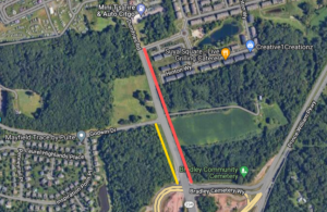
Along the west side of Business Route 234, the shared-use path between at least Godwin Drive and the Bradley Cemetery Way area will provide safe foot and bicycle access to and from Godwin Drive heading west (including to the adjacent Mayfield Trace community) and could also connect to a future northwestern extension of the regionally significant shared-use path along the Prince William Parkway leading from the Brentsville Road Interchange.  In addition, the nearest shared-use path within the City of Manassas is along the west side of Business Route 234, between Hastings Drive and Donner Drive.

Along the east side of Business Route 234, a shared-use path from the Bradley Cemetery Way area would provide optimal access to the shared-use paths being built within this Interchange project that a) head south to cross over Route 234 to reach both Brentsville Rd heading south and the existing regional path along southbound Route 234 and that b) meander east through the Interchange to reach Liberia Avenue Extended/Route 294 toward Manassas.

A shared-use path along the east side of Business Route 234 would optimally connect to the existing Bradley Square townhome development and the proposed Bradley South (REZ2003-00027) development.  From Bradley Manor Place, the existing Bradley Square subdivision streets readily lead to South Grant Avenue in the City of Manassas, a pleasant, existing low-traffic route for bicycling and walking that connects to Wellington Road (and from there to downtown Manassas via multiple routes).
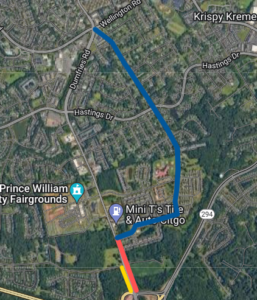
We are disappointed that the current Bradley South rezoning proposal is rather inhospitable for bicycling and walking.  Business Route 234/Dumfries Road would have a 50 MPH design speed and a 45 MPH posted speed limit, and the developer of Bradley South would only be required to proffer a sidewalk along the east side of Dumfries Rd.  By contrast, the connecting segment of Dumfries Road at the south end of the City of Manassas has only a 35 MPH posted speed limit (which is better but also too high in our opinion).

Furthermore, with continued residential, commercial, and mixed-use development along the Business Route 234/Dumfries Road corridor (including the Prince William County Fairgrounds), just south of the Manassas City Limits, the density of development will be comparable to that planned along Centreville Road (Route 28) in Yorkshire.
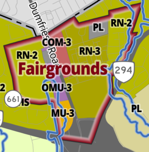
We ask that the budget surplus from this project and proffers from the Bradley South rezoning be used to provide a 10-foot wide shared-use path along the east side of that roadway (Dumfries Rd), from the Bradley Cemetery Way area to at least Bradley Manor Place.

Beyond that, to the extent feasible, the Interchange Project budget should also provide much-needed pedestrian infrastructure for crossing Business Route 234/Dumfries Road at Godwin Drive, including high-visibility crosswalks, at least one raised pedestrian crossing refuge within the roadway median, and either a pedestrian-activated crossing beacon (e.g., HAWK signal) or a conventional traffic signal with full pedestrian crossing components for at least two of the existing intersection legs.

Please let us know how the Route 234/Brentsville Road Interchange Project will suitably accommodate active mobility to and from the already well populated Business Route 234/Dumfries Road corridor.

Without safe and convenient foot and bike connections to the new Interchange from Business Route 234, the new Interchange will degrade active mobility to and from that populated corridor, and the new active transportation infrastructure within the interchange will be very underutilized.  Waiting five or more years for possible future rezonings along Business Route 234/Dumfries Road is not acceptable to complete these critical sections.

If the surplus funds from the Interchange project cannot be tapped to build either another shared-use path or a signalized pedestrian crossing of Business Route 234/Dumfries Road at Godwin Drive, we believe that low-cost or no-cost alternative interim improvements could readily be implemented along the east side of Business Route 234/Dumfries Road that would still substantially improve pedestrian and bicycle access and safety between the Bradley Cemetery Way area and Bradley Manor Place.

Google Street View shows that–before the Interchange was constructed–the paved width of Business Route 234/Dumfries Road was already about four or five lanes wide (i..e., 48 to 60 feet of asphalt pavement) for most of the distance between Bradley Cemetery Way and Bradley Manor Place.  There appears to be only a short stretch between Godwin Drive and the south end of Bradley Square where the pavement narrows to about 36 feet, but only two lanes are presently needed for vehicular travel along that segment.

Thus, the restriping of that roadway segment (with or without any asphalt resurfacing) should allow for at least a continuous 10-foot or wider northbound paved shoulder area leading up to the long right-turn-only lane approaching Bradley Manor Place.  That shoulder area could be protected from roadway traffic with some sort of hard physical barrier to serve as an interim shared-use path along the east side of Business Route 234/Dumfries Road between the Bradley Cemetery Way area and Bradley Manor Place.

This recent photo (below) of northbound Route 234 Business/Dumfries Road near Bradley Cemetery Way shows that a wide paved shoulder is already present at that location.  While less wide than optimal, that existing paved shoulder could serve as an interim two-way shared-use path if it’s protected from the roadway traffic with a suitable hard barrier.
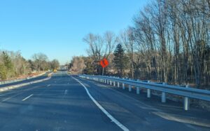
Northbound Business Route 234/Dumfries Road just north of the Interchange on February5, 2024

In addition, a striped conventional bike lane in each direction may also be feasible.  In the southbound direction, a striped on-road bike lane would be especially useful, from the Manassas City Line to Godwin Drive, for the dozens of bicyclists who participate in Bull Run Bicycles Tuesday Evening Shop Ride, almost every Tuesday evening during daylight saving time.  South of Godwin Drive, a southbound bike lane should not be needed because a new shared-use path will be located along that segment.

Finally, we again request that whatever pedestrian and bicycling improvements cannot be accomplished under the current Interchange project become required proffers as part of the Bradley South rezoning.
Our Comments to NVTA for 2023

The Northern Virginia Transportation Authority held an public annual hearing on January 12, 2023.  Active Prince William’s co-chairs delivered the statements reproduced below.


Statement by Allen Muchnick, City of Manassas Resident

2022 was a busy year for the Authority.  While the processes for updating TransAction and the Six-Year Program were badly flawed, I appreciate that the outcomes were better than many had feared.

I urge the Authority to devote 2023 to reevaluate its approach to transportation project development in our region, to better align its processes and outcomes with its Core Values of Equity, Sustainability, and Safety and its goal of developing “an integrated multimodal transportation system that enhances quality of life, strengthens the economy, and builds resilience.”

A transportation program that—in our outer suburbs–is heavily focused on expanding fast, multilane arterials is neither equitable nor sustainable and only worsens safety and access for vulnerable road users and non-motorists.  NVTA funding—which is devoid of any motor vehicle user fees—has not effectively addressed our region’s growing traffic violence problem.

The Authority should establish a task force this year to reevaluate its fundamental policies and procedures, starting with its statutory emphasis on reducing traffic congestion.  The recent TransAction planning process found that–even if our region could obtain $75 billion to complete every listed project over the next 23 years—traffic congestion overall would be essentially unchanged.  The Authority should evaluate more cost-effective, equitable, sustainable, and safer approaches to regional transportation planning and investment and then recommend changes to its current statutory mandate to the Virginia General Assembly.

A simpler, yet much-needed, NVTA reform would require advertised public hearings before a relevant governing body endorses any project for NVTA-related funding, including from the CMAQ and RSTP programs.  Currently, such funding requests are often developed behind closed doors and simply placed on the governing body’s consent agenda.  Requiring advertised public hearings before governing body endorsement could alter the mix of the submitted projects and/or expand or modify their scope in light of the early public input.

The Authority also needs to develop and adopt a robust Complete Streets policy, to ensure that all NVTA-funded projects adequately meet the access and safety needs of vulnerable road users.  Early public involvement before projects are submitted for funding is related to this need, to ensure that project scopes and funding allocations will properly accommodate vulnerable road users.

Thank you for this public comment opportunity and for considering my recommendations.


Statement by Mark Scheufler, Prince William County Resident

Good Evening. Mark Scheufler. Prince William County.  Thank you for the opportunity to address you tonight.

To meet the regional, state, and federal greenhouse gas emission objectives and goals, a structural change in the transportation planning and investment needs to occur.  In addition to improved vehicle emission standards and investing in electric vehicles and infrastructure, vehicle miles traveled (or VMT) for Single Occupancy Vehicles as a whole needs to decrease, even as the Northern Virginia population grows.  At a basic level, this means that we need to stop expanding unmanaged roadway lane miles.

This means the recently adopted TransAction plan would need a major modification.  Any government funding for highway expansion is one less $ going to meeting these urgent climate goals in the transportation sector.  We need to change the paradigm that Congestion is reduced–not by adding unmanaged roadway supply to the system–but by reduced Single Occupancy Vehicle travel demand.  This will require reducing car dependency by developing near high-capacity transit, repurposing roadway space for transit and non-motorized users, and reforming parking requirements and level of service standards, especially in outer jurisdictions.

The one roadway widening project that I do support, that is currently being studied, is modifying the I-95 express lanes to a bi-directional configuration.  Somehow this is not included in the $74B TransAction list.  According to the TransAction documents, NVTA supports more general-purpose widening of the existing I-95 roadway that VDOT indicated would be a very poor investment.

But this only makes sense if jurisdictions simultaneously take advantage of the opportunity to transform the currently adjacent high-speed deadly Route 1 arterial  corridor in Fairfax and Prince William.

I applaud Arlington County staff for recommending a 25 mph design speed for their section of Route 1 through the National Landing area.  I would hope it can be a model, along with dedicated transit lanes in the Route 1 corridor, for all the other jurisdictions from Pentagon City to Dumfries.  These types of regional initiatives should be the focus for the NVTA this coming year.

###

Our Comments on NVTA’s Draft Transportation Plan

On September 8, 2022, the Northern Virginia Transportation Authority held a public hearing on its draft five-year update to TransAction, the regional authority’s long-range transportation plan for Northern Virginia.   Active Prince William’s co-chairs, Mark Scheufler and Allen Muchnick, delivered separate oral statements at this hearing, and both statements are posted below.  

A recording of the public hearing, which featured 21 citizen comments, is here.  Mark’s statement begins at 1:10:50 in this recording, while Allen’s statement follows immediately at 1:13:40 .

Additional written statements submitted on September 18, 2022:


Good Evening.  Mark Scheufler, Prince William County.  Thank you for the opportunity to address you tonight.

I am a member of Active Prince William, which is a volunteer group of concerned citizens who advocate for better opportunities, support, and infrastructure for active transportation and healthy lifestyles within Prince William County, Manassas, and Manassas Park.

I have reviewed the list of projects and associated documentation in the TransAction package and continue to be disappointed in the goals and outcomes of this process.

I do not believe a directionless, hodgepodge, all-the-above-list-of-projects approach of expanding capacity to reduce roadway congestion is the best path for the region.  Reform to the NVTA statute is needed.

I compare the Northern Virginia transportation situation as it relates to congestion to be comparable to obesity.  The solution for obesity should not be to loosen the belt for extra capacity which is similar to the 20th century concept that unmanaged road widening is a solution to congestion in urban areas such as Northern Virginia.

Unfortunately the Transaction list includes 117 projects with the word “Widen” in it.

This update to the TransAction along with the NVTA statute will continue to point outer jurisdictions of Fairfax, Prince William and Loudoun to submit car-first projects that serve to increase car dependency to future six-year funding programs.

In addition, while excellent projects, the fact that the 24th, 25th and 26th ranked projects (out of 26) in the last six year plan were funded, diminishes the value and purpose of the NVTA and questions whether funding should just go directly to the jurisdictions based on the funding contributed by each jurisdiction.

For Prince William County, with all the traffic information available, the best fully funded project in the last six year plan was a roadway extension through a data center development.  Prince William County probably could have developed better outcomes outside of the NVTA process and restrictions.

In closing, I will submit this testimony via email and provide a list of project additions, subtractions and modifications for consideration as many of my concerns discussed here will not be addressed in this TransAction process.  But I hope NVTA reform can be addressed by the state legislature to create better land use and transportation outcomes for all Northern Virginia residents.  Thank you.


Good Evening.  I’m Allen Muchnick.  I live in the City of Manassas, and I also serve on the board of Active Prince William, an active mobility advocacy group.

The Northern Virginia Transportation Authority’s transportation planning and programming processes are fundamentally flawed, starting with its statutory mandate to focus on traffic congestion, while ignoring the critical roles of land use and induced demand as well as the environmental, equity, and traffic-safety problems caused by our region’s over-dependence on auto travel.

Northern Virginia’s roadways have been expanded for the past seventy years, yet we still face perpetual traffic congestion, and most NoVA residents will continue to lack viable alternatives to driving alone for most local trips.  Repeating the same activity over and over and expecting a different result is the definition of insanity.

Developing an independent Northern Virginia transportation plan that does not reinforce and advance the goals, objectives, and strategies of Visualize 2045–the federally mandated long-range transportation plan for the entire Washington region–is counterproductive and foolish.  An unconstrained and un-prioritized transportation project wish list, whose price tag far exceeds the funding that is expected to become available before 2045, is largely a wasteful exercise.

In June 2022, the TPB committed to a strategy of completing all planned segments of its National Capital Trail Network (NCTN) by 2030.  Yet, no planned National Capital Trail Network segments are identified in the TransAction project list, and it’s likely that many are not even included.

In the TransAction project list, many of the road-widening and interchange proposals do not mention the inclusion of associated pedestrian and bicycling elements, which might be new, upgrades, exact replacements, or preserved preexisting facilities.  For over 18 years, VDOT has operated under a Complete Streets policy adopted by the Commonwealth Transportation Board.  The NVTA also needs to adopt a Complete Streets policy that requires all NVTA-funded projects to incorporate all related pedestrian and bicycling accommodations as safe, direct, and efficient facilities, unless one or more specified exemptions exist.

Another much-needed, yet simple, NVTA reform would require advertised public hearings before the relevant governing body endorses any project for NVTA-related funding, including federal RSTP and CMAQ allocations endorsed by the NVTA.

Thank you for this opportunity to comment orally.  I plan to submit more detailed written comments via email by the September 18 deadline.

Our Final Comments on the Northern Virginia Transportation Authority’s Six-Year Program Update

On July 11, 2022, Active Prince William joined 10 other advocacy organizations around Northern Virginia to send the following joint letter to the Northern Virginia Transportation Authority, three days before the Authority’s scheduled adoption of a two-year update to its Six-Year Program.


Coalition for Smarter Growth | Audubon Naturalist Society | Virginia Sierra Club |
Faith Alliance for Climate Solutions | Active Prince William | Sustainable Mobility for Arlington County |
Chesapeake Climate Action Network | Prince William Conservation Alliance |
Southern Environmental Law Center | YIMBYs of Northern Virginia |
Lewinsville Faith in Action

July 11, 2022

Honorable Phyllis Randall, Chair
Northern Virginia Transportation Authority
3040 Williams Drive, Suite 200
Fairfax, VA 22031

Re: Recommendations to further improve the proposed FY 22-27 Six-Year Program and process going forward

Chair Randall and NVTA board members:

The undersigned 11 organizations offer the following comments and recommendations that we urge you to adopt for the proposed FY 22-27 Six-Year Program coming before your vote this week.  In summary:

  1. We support the overall direction taken by the staff and committees in their selections from the candidate project list to fund all transit and most station access and local complete street projects;
  2. However, we remain concerned that the slate of projects recommended for funding – and the original candidate list – show a program still too focused on road expansion;
  3. We ask for important changes to the proposed FY 22-27 funding allocations in Prince William County: fund the Old Centreville Rd Widening project (PWC-035) as an alternative to the proposed destructive Rt 28 bypass (Alt. 2B) along Flat Branch;
  4. For the next 6-year program cycle, NVTA needs to ensure that local jurisdiction project submissions better reflect adopted regional policies for climate change and equity; and
  5. NVTA’s process for the Six-Year Program should facilitate meaningful public involvement from the start, including requiring public hearings prior to local government candidate project submissions.

These points are elaborated on the following pages.


1. We support the overall direction taken by the staff and committees in their selections from the candidate project list.

 We applaud the selection and funding of all of the transit projects and most of the station access, local street grid and complete streets projects.

 We appreciate that many of these changes reflect attention to public feedback you received and the importance of these projects for a more sustainable and equitable future.


2. However, we remain concerned that the slate of projects recommended for funding – and the original candidate list – show a program still too focused on road expansion.

65% of the candidate project funding requested was for highway and roadway capacity expansion.

55% of the staff recommended project funding is for highway and roadway capacity expansion.

These amounts are far too much given the other regional needs for safer streets, transit access, electrification, and climate resilience as well as improving our
transit, pedestrian and bicycle networks.

 This emphasis on road expansion also ignores the reality of induced demand, that widening roads is not a medium- or long-term solution for vehicle congestion, as shown in the Coalition for Smarter Growth’s On the Wrong Road in Northern Virginia report using the RMI Shift Calculator.


3. We ask for these important changes to the proposed FY 22-27 funding allocations in Prince William County:

Support a better, less destructive Route 28 project in Prince William County by funding the Old Centreville Road Widening project (PWC-035) as an alternative to the Route 28 bypass (Alternative 2B) along Flat Branch. The four-laning of Old Centreville Road combined with VDOT’s recommended Centreville Road/Route 28 STARS improvement package could effectively serve as a “Modified Alternative 4” for Route 28.

   This alternative project would avoid the adverse impacts to affordable homes in a low-income minority and immigrant community from the 28 Bypass project and would be compatible with walkable, transit-accessible economic development and neighborhood livability efforts in the existing Route 28 corridor.

To accommodate this project, shift funding from other NVTA recommended Prince William projects.


4. For the next Six-Year Program cycle, NVTA needs to ensure that local jurisdiction project submissions better reflect adopted regional policies

NVTA needs to require that local jurisdiction project submissions better reflect adopted regional policies to provide alternatives to driving and reduce car dependence, support transit-oriented land use, and achieve our equity and climate goals.

Equity in transportation, a core value of NVTA, must address the disproportionate impact of unsafe streets, proximity to traffic and pollution, and high personal transportation costs that auto-dependence causes for low- and moderate-income residents and workers. The Region Forward vision plan recognizes this in its goal to lower combined transportation and housing costs and to also improve access to travel options and allow more residents to live in walkable regional activity centers with good transit. These measures also reduce travel demand on roads and highways helping those who must commute or access important services by car. NVTA needs to ensure that its member jurisdictions consider who benefits and who is harmed by transportation projects.

The region’s Metropolitan Planning Organization, the National Capital Region Transportation Planning Board (TPB), just adopted a greenhouse gas reduction target of 50% for the on-road transportation sector. NVTA’s project selections should be tied to achieving those reductions. TPB’s climate change study showed that the region will need to reduce vehicle miles traveled of passenger vehicles by 15 to 20% below 2030 baseline forecasts, as well as rapidly adopt electric vehicles.

Tackling climate change in transportation also provides more travel options, greater proximity to jobs and services, lasting congestion management, and addresses inequities for households and workers regarding street safety, air quality, walkable amenities, personal transportation costs, housing options, and access to transit and job locations. With new car payments now over $700 per month and gas at $5 per gallon, the need in Northern Virginia for more walkable, bikeable, transit-friendly, mixed-use and compact communities with affordable housing is greater than ever.

Reducing per capita VMT – the need to drive for daily needs – by expanding transportation options, transit-oriented land use, and transportation demand management is also essential to meeting NVTA’s goal of reducing congestion.


5. NVTA’s process for the Six-Year Program should facilitate meaningful public involvement from the start, including local government candidate project submissions.

Since project priorities are advanced early on by local governments, NVTA must ensure that there are accessible public engagement opportunities early on.

NVTA should require that localities hold an advertised public hearing for NVTA project funding requests before the local governing body adopts its resolution of support for the application and before the projects are submitted to NVTA for funding consideration.

   Currently some jurisdictions generate staff reports and the elected body approves the project submissions as a consent agenda item with no public hearing.
   Public comments on proposed NVTA project submissions would be more  meaningful and help inform the local government before each set of projects is submitted to the NVTA for the Six-Year Program update.

In addition, NVTA coordinates the submissions for federal CMAQ and RSTP funds and for state SmartScale by Northern Virginia localities and should require similar transparency and public involvement before local governing bodies endorse those submissions.

Thank you for listening to stakeholders as you have carried out this process.

Sincerely,

Stewart Schwartz
Executive Director
Coalition for Smarter Growth
stewart@smartergrowth.net

Renee Grebe
Northern Virginia Conservation Advocate
Audubon Naturalist Society
renee.grebe@anshome.org

Douglas Stewart
Transportation Co-Chair
Virginia Sierra Club
douglasbstewart@gmail.com

Andrea McGimsey
Executive Director
Faith Alliance for Climate Solutions
andrea@faithforclimate.org

Mark Scheufler & Allen Muchnick
Co-Chairs
Active Prince William
Active.PrinceWilliam@gmail.com

Chris Slatt
President
Sustainable Mobility for Arlington County
Hello@susmo.org

Zander Pellegrino
Northern Virginia Grassroots Organizer
Chesapeake Climate Action Network
zander@chesapeakeclimate.org

Kim Hosen
Executive Director
Prince William Conservation Alliance
khosen@pwconserve.org

Morgan Butler
Senior Attorney
Southern Environmental Law Center
mbutler@selcva.org

Luca Gattoni-Celli
Founder
YIMBYs of Northern Virginia
potentiaeromanorum@gmail.com

Jack Calhoun and John Clewett
Co-Chairs
Lewinsville Faith in Action
clewettj@gmail.com

While Better, the Revised Design of the Route 234-Brentsville Road Interchange in Still Badly Flawed

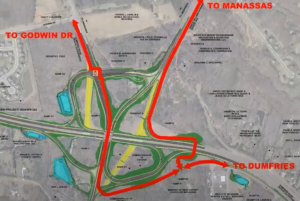
Prince William County DOT’s currently proposed circuitous trail routing through the Interchange, assuming that a direct trail bridge connecting the existing Route 294 and Route 234 Trails is included in this project

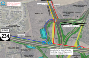
Our proposed trail connections through the planned interchange to reach Route 234 Business (red line) and the future trail along the Route 234 Bypass (blue line).  A trail (red line) running along the north side of Route 234 would pass underneath both new roadway overpasses. The three light blue circles show where box culverts could allow the trail to be routed beneath highway ramps.  The areas shown in yellow are existing roadways that are planned to be removed.  This design eliminates all at-grade trail-roadway crossings, except to reach Route 234 Business.  However, by building a shared-use path along the west side of Route 234 Business (connecting to Godwin Dr), trail users would be required to cross only 5-lanes of stopped traffic at just the western leg of the signalized intersection of Bradley Cemetery Way and Route 234 Business, not 12-lanes of stopped traffic plus one lane of free-flowing right-turning traffic at two separate legs of that intersection.

This post follows up on the comments we previously submitted in response to the December 8, 2021 Design Public Hearing for Prince William County DOT’s Route 234-Brentsville Road Interchange Project.

On March 18, 2022, the County released this followup video presentation on the proposed project design.   County DOT staff are willing to at least partly addresses three concerns with the proposed trail connections that were raised at the Design Public Hearing:

1) In response to public comments from Active Prince William and others, the County is now studying the cost feasibility of a new, dedicated trail bridge over Rte 234, just east of the interchange, to directly connect the existing trails along Route 234 and Route 294.   If this trail bridge can be added without the project exceeding it’s $55 million budget, it will be included in this project.   Otherwise, it probably won’t.

2) In response to safety concerns raised by many about the four proposed closely spaced at-grade trail crossings of free-flowing highway ramps near Route 294 and Bradley Cemetery Way in the northeast corner of this project, those hazardous at-grade trail crossings may not be built, at least if the added trail bridge discussed above is actually built.    However, this change would produce a long, circuitous trail route between the western legs (Route 234 Bypass and Route 234 Business) and eastern legs (the existing trails along Routes 234 and 294) of this interchange (shown in the top image above).

3) In response to objections that the design completely omits the long-planned trail along the Route 234 Bypass that should join the existing trails along Route 234 and Route 294,  the design team has identified a future location for this trail along the northwestern edge of the interchange (see the blue line in the second image above).

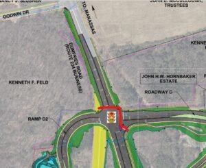
However, all trail connections to and from Route 234 Business and the long-planned future trail along the Route 234 Bypass (aka Route 234 North) would still require a two-stage at-grade crossing of 12 signalized traffic lanes plus one free-flowing right-turn lane at the rebuilt intersection of Bradley Cemetery Way and Rte 234 Business plus a second at-grade trail crossing of a free-flowing highway ramp at the south side of the interchange (at the on-ramp from Brentsville Road) .  Those remaining design flaws would still create considerable delays and hazards for trail users.

Under Prince William DOT’s revised design for this interchange, this slow and hazardous crossing of 13 traffic lanes at two legs of the signalized intersection of Bradley Cemetery Way and Route 234 Business would remain.  All trail access and egress from either Route 234 Business or the future trail along the Route 234 Bypass would need to use this routing to join either of the existing trails along Route 234 and Route 294 or Brentsville Road.

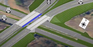
As a followup proposal, we suggest routing the long-planned trail along the Route 234 Bypass along the north side of Route 234 (per the second image from the top), connecting that trail to both the existing Route 294 Trail to the east and to a new shared-use path along the west side of Route 234 Business (where the existing pavement, depicted in yellow, is planned for removal).   This trail (depicted with a red line in that image) would pass underneath both new roadway overpasses being built to carry Brentsville Road and Route 294 over Route 234 and could also pass underneath three single-lane interchange ramps inside box culverts (see the light blue circles).

Under our proposal, the long-planned trail along the Route 234 Bypass would run along the north side of Route 234 and pass under both planned roadway bridges.


Three short box culverts could be used to route our proposed trail along the north side of the Route 234 Bypass beneath three one-lane interchange ramps.  Only one such box culvert would be needed for the connection to Route 234 Business.

Our proposed design eliminates all at-grade trail-roadway crossings, except to reach Route 234 Business.  However, by building a shared-use path along the west side of Route 234 Business (connecting to Godwin Dr), where only a sidewalk is currently planned, trail users would be required to cross only 5-lanes of stopped traffic at just the western leg of the signalized intersection of Bradley Cemetery Way and Route 234 Business, not 12-lanes of stopped traffic plus one lane of free-flowing right-turning traffic at two separate legs of that intersection.

Our proposal could also lower the cost of this project by eliminating the need to include a 14-foot wide shared-use path on the proposed Brentsville Road bridge.

Active Prince William believes that first-class, safe and direct trail connections for all five legs of this interchange can and should be provided within this project’s existing budget of $55 million.

« Older posts Newer posts »