Advancing active mobility in greater Prince William, Virginia

Category: City of Manassas (Page 1 of 3)

Our Comments on the Proposed Prince William Parkway and Clover Hill Road Diverging Diamond Interchange

Proposed diverging diamond interchange at Prince William Parkway and roundabout at Godwin Drive

Proposed diverging diamond interchange at Prince William Parkway and roundabout at Godwin Drive

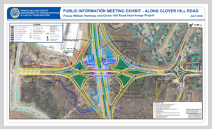
On July 30, 2026, Prince William County’s Department of Transportation and Capital Construction held a public information meeting to present and discuss its preliminary proposal to construct a diverging diamond interchange (DDI) at Prince William Parkway and Clover Hill Road, to reduce travel delays along the Parkway and accommodate the planned introduction of scheduled commercial airline service at the newly renamed Washington Manassas Airport.

On August 12, 2026,  Active Prince William Co-Chair Allen Muchnick submitted the following public comments to supplement the comments submitted previously by Co-Chair Mark Scheufler and by member Connor Young, both of whom are professional engineers.   Connor’s detailed comments in the form of a PowerPoint presentation can be viewed here.


Re: Proposed Design for the Prince William Parkway and Clover Hill Road Interchange Project

I’m writing on behalf of Active Prince William to comment on the proposed design for the Prince William Parkway and Clover Hill Road Interchange Project as presented at the July 30, 2026 public information meeting.   This letter supports and expands upon the comments previously submitted by Active Prince William members Mark Scheufler and Connor Young.

1. Examine More Cost-Effective Alternatives to a Diverging Diamond Interchange:

A diverging diamond interchange seems excessive for the anticipated future traffic volumes at this location, and we recommend that the project team evaluate an interchange design similar to that recently approved for the Prince William Parkway/Sudley Manor Drive Interchange which would serve both Sudley Manor Drive and Wellington Road traffic.

For 2025, the annual average daily traffic (AADT) volumes along these adjoining segments of Clover Hill Road (Rte 3235) was only 3200, far less than the traffic volumes on the two existing Prince William County highways with diverging diamond interchanges, both of which are high-speed, high-volume, median-divided arterial roadways.  Route 15 at I-66 had a 2025 AADT of 38,000, whereas Balls Ford Road (Rte 621) at Prince William Parkway had an AADT of 20,000.  Thus, Clover Hill Road would still carry far less traffic than either existing diverging diamond interchange did in 2025, even if Clover Hill Road traffic volumes were to double or triple with the future expansion of Washington Manassas Airport.

For the proposed Prince William Parkway/Sudley Manor Drive interchange, the existing at-grade intersections along Prince William Parkway at both Sudley Manor Drive and Wellington Road would be modified to allow only right-in and right-out traffic movements, and both Sudley Manor Drive and Wellington Road would cross over the Prince William Parkway on a single new roadway overpass on a new alignment.

In 2025, Sudley Manor Drive had an AADT of 26,000 on the east side of Prince William Parkway, while the adjoining segment of Wellington Road had an AADT of 18,000.  If such an interchange design can handle two arterial roads with a combined AADT of 44,000, a similar interchange design should have ample capacity to accommodate Clover Hill Road well into the distant future.
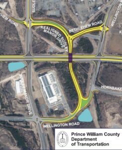
 

The approved design for the Prince William Parkway Interchange at Sudley Manor Drive and Wellington Road

Thus, the design team should explore a Clover Hill Road-Prince William Parkway interchange design where Clover Hill Road’s existing at-grade intersections with the Parkway are modified to allow only right-in and right-out traffic movements, and a new Clover Hill Road overpass of the Parkway would be constructed on a different alignment.

Even if Clover Hill Road traffic volumes were to grow five- or six-fold in the future, this new Clover Hill Road bridge should function effectively with only one travel lane in each direction (and only a single shared-use path and no sidewalk along one side of the bridge should be adequate).  The project savings due to the narrower and simpler bridge could be enormous.  The bridge roadway could connect to the existing segments of Clover Hill Road with either roundabouts or signalized intersections.
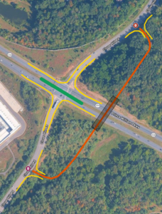
Our alternative, lower-cost proposal for the Prince William Parkway and Clover Hill Road Interchange

It does not appear that such an interchange concept has been evaluated for this project.  If indeed feasible, this alternative concept should cost considerably less to build and be much easier to fully fund.

2.  Extend the Project Limits Northwest Along Godwin Drive in the City of Manassas to Reach Winged Elm Circle

Godwin Drive in the City of Manassas–between Clover Hill Road and the southeast leg of Winged Elm Circle–has only one narrow sidewalk, no shared-use paths, and no bicycle lanes.  To provide continuous on-road bike lanes between the proposed roundabout and the southeast leg of Winged Elm Circle, the project limits should be extended northwest about 850 feet along Godwin Drive to Winged Elm Circle.  Ideally, a second sidewalk or a shared-use path should also be constructed along this segment of Godwin Drive along its northbound side.
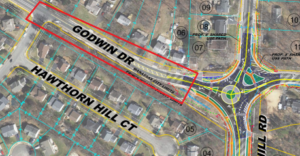
Godwin Drive between the proposed roundabout at Clover Hill Road and the southeast leg of Winged Elm Circle

Building this missing bike lane segment would finally provide a continuous bicycle facility along Godwin Drive between Hastings Drive and Clover Hill Road.  As traffic volumes increase along Godwin Drive due to the future expansion of Washington Manassas Airport, the need for a continuous bicycle facility will grow considerably.

3.  Install Shared-Lane Markings to Guide Bicycling Movements though the Clover Hill Road-Godwin Drive Roundabout.

Although the proposed design includes shared-use paths along the rebuilt segments of Clover Hill Road and along the roundabout, most people bicycling through the roundabout will be approaching and leaving the roundabout on the roadway and won’t necessarily access any shared-use path unless they are traveling to the airport along the rebuilt segment of Clover Hill Road.
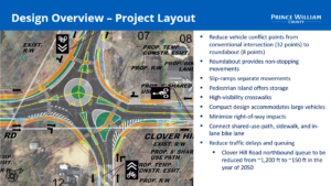
Proposed roundabout at Clover Hill Road and Godwin Drive

Installing shared-lane bicycle markings (sharrows) within the roundabout would especially help guide bicycling movements between both legs of Godwin Drive and the leg of Clover Hill Road approaching the City of Manassas and also assist in calming traffic.

4.  Design the Interchange to Effectively Accommodate the Planned Future Shared-Use Path along Prince William Parkway.

We appreciate that the design of this project would incorporate the right-of-way for a future shared-use path along the northbound side of the Prince William Parkway.  Please ensure that the design of this project would a) accommodate that shared-use path without any motor-vehicle cross-flows and b) connect seamlessly to the new shared-use paths along Clover Hill Road that will be built as part of this Interchange project.

One way to accomplish this would be to incorporate box culverts in this project beneath all new parkway exit and entrance ramps on the northbound side of the Parkway, to provide a safe and efficient underpass route for the future shared-use path along the Parkway.  Doing so would also reduce the cost and disruption needed when the long-planned shared-use path along this segment of the Parkway is finally built.

5.  Appropriately Design Clover Hill Road on the East Side of the Parkway and the Roundabout at Godwin Drive for Slow Vehicular Speeds through Residential Neighborhoods.

While the proposed lane widths and vehicular capacity for Clover Hill Road and the DDI Bridge seem excessive and would unnecessarily inflate project costs and degrade highway safety, it is especially important that Clover Hill Road on the east side of the Parkway and the Godwin Drive Roundabout be designed for slow (under 25 MPH) travel speeds appropriate for residential neighborhoods.  In that regard, the travel lanes and circulatory lanes in the roundabout should be 10 feet (or at most 11 feet) wide, especially since a wide truck apron in the roundabout would adequately accommodate all oversized vehicles and since the roundabout would include a dedicated right-turn-only lane for traffic heading southeast on Godwin Drive.

In addition, residential traffic-calming measures, such as speed humps along northbound Clover Hill Road and speed tables at the crosswalks within the roundabout should be considered.


Thank you for giving the public this opportunity to comment at an early stage of project design.  We very much appreciate the commitment of the project team to integrate pedestrian and bicycling infrastructure and safe roadway crossings into the design of this project.


Our Comments for the National Capital Trail Network Update in Greater Prince William

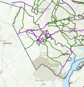
October 2023 draft update of the National Capital Trail Network in greater Prince William.  The green lines are supposed to depict existing trail segments, whereas the purple lines are supposed to depict “planned” trail segments.

The National Capital Trail Network (NCTN) is a 1,400-mile, continuous network of long-distance, off-street trails, serving the entire [metropolitan Washington] region and consisting of both existing and planned segments.  The network was approved by the National Capital Region Transportation Planning Board (TPB) in July 2020 and endorsed by the Metropolitan Washington Council of Governments Board of Directors in August 2020.

As described by TPB staff:  The National Capital Trail Network is intended to be a network of long-distance, off-street facilities. It will be accessible for people of all ages and abilities, designed for non-motorized use, and suitable for both transportation and recreation.  Off-street path width minimums are 10 feet for new construction, 8 feet for existing paths. Paths must be paved or firm surface. On-street facilities must be protected from moving traffic (i.e. parked cars, curbs, or flexposts). All facilities must be directly connected to the network. Short on-street connections on low-volume, low speed streets are permitted to maintain network continuity. Facilities can be existing or planned, but they must be in an approved agency plan.

In June 2022, the TPB adopted a resolution (R18-2022) that called for completing the TPB’s National Capital Trail Network by 2030, as one of seven priority strategies for reducing greenhouse gas emissions from surface transportation in the Washington region.

For at least several months, the TPB staff have sought to engage the region’s localities to submit updates and corrections to the NCTN mapThe main purpose of this update is to measure progress, in miles built, toward the completion of the National Capital Trail Network since its adoption in 2020. Other purposes include adjusting routes where the existing route has proven infeasible or undesirable, addition of new routes where a new plan or new development justifies it, and correction of errors or omissions in the network [emphasis added].

To facilitate this update, Active Prince William submitted the comments below on October 30, 2023.


Comments on the Draft Update to the National Capital Trail Network Map for Prince William County and the City of Manassas
by Allen Muchnick, Co-Chair Active Prince William

1) Nonexistent/”Planned” Trail Segments Erroneously Labeled As “Existing”:  The following segments on the NCTN map should be relabeled as “planned” because they do not currently exist.

  • Nokesville Rd/Rte 28 between the Fauquier County Line and Fitzwater Dr in Nokesville. The segment of Rte 28 west of Fitzwater Dr in Nokesville has not been widened.  It’s still a two-lane road without any bicycle or pedestrian facilities.
  • Minnieville Rd, between Old Bridge Rd and Dumfries Rd, is depicted as having an existing shared use path along it except for the segment (TIP_ID BP11611) between Fowke Ln and Cardinal Drive. However, the NCTN update map erroneously shows this planned segment with a southwest terminus at Smoketown Rd, rather than at Cardinal Dr.  The segment of Minnieville Rd that currently lacks any bicycle facilities is much longer than shown on the NCTN update map.

2) NCTN Segments Currently Labeled As Planned That Have Recently Been Completed:  The following NCTN segments should now be relabeled as “existing”.

  • Nokesville Rd/Rte 28 Shared-Use Path, between Godwin Dr and the PWC Line, in the City of Manassas (TIP_ID 11606).
  • Godwin Dr Shared-Use Path (south), between Wellington Rd and the Winters Branch Trail, in the City of Manassas (TIP_ID BP11604). Note: TIP_ID BP7624 appears to be a duplicate path, possibly on the PWC side of Godwin Dr, which is probably not actually planned and, if so, should be deleted from the map.
  • US-1 Shared-Use Path in North Woodbridge (southern segment of TIP_ID BP7634): The segment between Annapolis Way and Gordon Blvd is complete.
  • Blackburn Rd Shared-Use Path near Neabsco Creek (the bulk of TIP_ID BP7641): The segment between Rippon Blvd and Good Shepherd Lutheran Church is complete.
  • Wellington Rd Shared-Use Path (the western end of TIP_ID 7632): The segment between Linton Hall Rd and University Blvd near Gainesville/Virginia Gateway is complete.
  • VA 234/Dumfries Rd Shared-Use Path (TIP_ID BP7639): This former gap segment between Country Club Dr and Exeter Dr near Montclair is complete.

3) Planned NCTN Segments Depicted On An Erroneous Alignment:

4) Planned NCTN Segments That Should Be Updated: 

  • Manassas Dr east of Signal View Dr in Manassas Park (TIP-ID BP7643): The new Manassas Park Active Transportation Plan identifies an even larger segment of eastern Manassas Dr (between Railroad Dr and Blooms Park) as a candidate for bicycle lanes implemented with a road diet (Project B-10). The NCTN map currently labels the segment of Manassas Dr east of Signal View Dr as planned for a shared-use path.

5) Nationally Significant Long-Distance Trails That Should Be Added to the NCTN Map As “Planned NCTN Segments”:

  • US Bicycle Route 1: At present, a considerable portion of US Bicycle Route 1 through Prince William County is quite hostile to bicycling, even by experienced cyclists.  However, the segments of this route along Fleetwood Dr (Fauquier County Line to Aden Rd), Aden Rd (Fleetwood Dr to Bristow Rd), Bristow Rd (Aden Rd to Independent Hill Dr), Independent Hill Rd (Bristow Rd to Route 234), all of Hoadly Rd, Minnieville Rd (the segment missing a shared-use path from Prince William Pkwy to Fowke Ln), and Old Bridge Rd (Minnieville Rd to Tanyard Hill Rd) are all identified for future shared-use paths in Prince William County’s December 2022 Comprehensive Plan and therefore should be depicted as Planned NCTN segments on the updated NCTN map.
  • East Coast Greenway and Potomac Heritage National Scenic Trail: Except to depict existing or planned sidepaths along Route 1, the current NCTN map does not depict most of the planned ultimate route(s) for the East Coast Greenway and the paved, shared-use segments of the Potomac Heritage National Scenic Trail through Prince William County.  The updated NCTN map should depict those planned routes.

###

Our Comments on the Mathis Avenue Improvement Project

On March 31, 2022, Active Prince William submitted the following comments to the City of Manassas regarding its proposed Mathis Avenue Improvement Project:


Re: Mathis Avenue Improvement Project (T-086) Public Meeting Comments

On behalf of Active Prince William, I’m writing to submit the following comments in response to the March 17, public meeting for the above-referenced project.  Our all-volunteer organization seeks improved active mobility and public transportation throughout greater Prince William, to create more livable, equitable, and sustainable communities.

An Improved Public Process for Transportation Project Development

We sincerely appreciate the improved process used to involve the public at the 30% design stage for this capital transportation project, which included both a February 23 virtual public meeting and an in-person meeting held on March 17.  This public involvement process is far better than the one used by City staff for its recent Sudley Road Third Lane Project, which excluded all public input before preliminary engineering was at least 90% complete (including when that project had been re-scoped substantially twice, in December 2017 and in February 2021).  We hope this public comment opportunity reflects a permanent policy change to proactively involve the public in all City transportation projects going forward, ideally starting at the project scoping stage.

The Proposed Design is a Reasonable Interim Aesthetic Improvement but Lacks Essential Pedestrian Amenities for a Vibrant, Mixed-Use Street

As a final condition for a revitalized Mathis Avenue as a mixed-use, pedestrian-oriented street–ideally with robust bus transit service–the proposed design would be a major disappointment.  However, as an interim improvement intended to transform the appearance of this somewhat desolate commercial street and to promote future mixed-use redevelopment at minimal cost, this project does appear to have merit.

In particular, the proposed design provides sidewalks that are too narrow for comfortable two-way walking, are too close to the roadway, and lack street trees and pedestrian-serving street furniture in what should be much wider curbside planting strips and furniture zones.   In addition, the sidewalks are interrupted with frequent curb cuts, where motor vehicle cross flows impede safe and comfortable walking.

However, considering the need for Mathis Avenue to continue serving the existing auto-oriented businesses beside it, especially along the east side of this street, until redevelopment occurs some years in the future, the imperative to minimize right of way takings and to preserve the existing curb cuts is understandable.

To effectively promote the specific forms of redevelopment that the City seeks and to ensure that this redevelopment incorporates the necessary mobility infrastructure to equitably support that redevelopment, the City’s Department of Planning and Community Development should undertake a robust community-based planning process to develop a detailed form-based zoning code for the Mathis Avenue corridor.  Form-base zoning codes are a proven tool to effectively promote the specific forms of redevelopment desired by localities.

Bicycling Accommodations and Roadway Design Speed

The lack of bike lanes (or any alternative bicycle facilities) in this project is disappointing but is also understandable since the existing curbs are not being moved to keep the existing storm sewer infrastructure in place, to minimize costs and commercial property impacts.  However, without bike lanes, the construction of raised medians will degrade bicycling conditions substantially, and those degraded conditions are unlikely to be remedied by a future roadway widening when the corridor is eventually redeveloped.

Presently, motorists can readily safely overtake people riding bicycles on Mathis Avenue by passing in the two-way central left-turn lane.  The raised medians, however, will prevent motorists from overtaking bicycle riders, who typically travel at 10-16 MPH.  Thus, people riding bicycles on Mathis Avenue will serve as slow-moving traffic-calming devices.  This roadway change will make bicycling unpleasant for nearly all riders and will subject people riding bicycles to increased harassment from frustrated motorists who are unable to pass.  Moreover, since Mathis Avenue would probably not be rebuilt with added bike lanes when redevelopment occurs in the future, this degradation of bicycling conditions on Mathis Avenue is likely permanent.

The fact that nearby Portner Avenue is designated as a bicycle route is no reason to degrade bicycling conditions on Mathis Avenue.  While many through bicyclists already prefer to travel on Portner Avenue, only Mathis Avenue serves the businesses and jobs located along Mathis Avenue, and people will someday live on this segment of Mathis Avenue too.

Thus, for both bicycle access and pedestrian safety, this project should strive to reduce the design speed for Mathis Avenue–and ideally the posted speed limit–to 20 MPH or below.   The raised median with street trees—and especially street trees in future curbside planting strips and future taller buildings closer to the roadway—should encourage motorists to drive more slowly on Mathis Avenue, but other design changes are needed too.

Shorter curb-return radii at corners and narrower sidewalk curb cuts would help reduce motor vehicle speeds, and electronic speed-feedback signs paired with posted speed limit signs (dynamic speed displays) would warn speeding motorists to slow down.  In addition, shared-lane markings (aka “sharrows”) centered in each travel lane would inform both motorists and bicycle riders that this is a shared roadway.

More Visible and Shorter Crosswalks

One notable design feature that should be changed is the proposed use of brick-colored stamped asphalt crosswalks.  While intended to impart historic charm, brown-colored crosswalks are far less conspicuous to motorists than modern high-visibility and reflective thermoplastic crosswalk markings.  The primary purpose of marked crosswalks is to alert motorists to the likely presence of crossing pedestrians, encouraging drivers to slow down, look for, prepare to yield to, and stop for pedestrians who may be crossing the roadway.  A faux-brick aesthetic is far less important than the safety of people who are walking across the street.

In addition, the final design of each intersection should pay particular attention to shortening the length of all crosswalks to the extent feasible and to install two separate curb ramps for the crosswalk landings at each corner.  The present design includes a single combined curb ramp at the southeast corner of Mathis Avenue and Sudley Road and at all four corners of Mathis Avenue and Liberia Avenue, the two on the north side not being rebuilt.

Designing shorter curb-return radii at all intersection corners, as suggested above to reduce the roadway design speed, would also reduce the crosswalk lengths at those intersections.

Consider Short Left-Turn Lanes at Reb Yank Drive and Carriage Lane

The advertised design does not include any space in the center of the roadway (beyond the intersection itself) to store vehicles waiting to turn left at Reb Yank Drive (from both directions) or southbound at Carriage Lane.  While shortening the raised medians to add short left-turn pockets at those three locations could increase travel speeds along Mathis Avenue and could also remove the proposed median refuges for crossing pedestrians at those unsignalized intersections, it may be prudent to add those left-turn pockets to smooth traffic flow, reduce traffic congestion, and lower the incidence of rear-end collisions at those locations.  However, if traffic studies have already documented that those left-turn pockets are unnecessary, then please retain them.

Thank you for considering our comments as you finalize the design of this project.

Active Prince William Advocates Reforms at NoVA Transportation Meeting

Active Prince William Co-Chairs Allen Muchnick and Mark Scheufler submitted the following statements for the Annual Joint Northern Virginia Transportation Public Meeting that was held on December 15, 2021.


Northern Virginia needs a transportation system that moves people and goods effectively, safely, equitably, and sustainably.  Sadly, our region’s pursuit of wider and faster roads over the past 70-plus years has failed to achieve those objectives. 

It’s long past time to stop expanding regional roadways for toll-free travel in single-occupant vehicles and instead focus new homes, jobs, and transportation investments in regional activity centers served by high-capacity public transportation and expeditiously retrofit existing arterial roads for safe and efficient travel by walking, bicycling, and bus transit. 

Robust and strategic Vision Zero programs are needed at the statewide, regional, and local levels, and the region should prioritize completion of the National Capital Trail Network.

We appreciate this annual joint transportation meeting and public comment opportunity for Northern Virginia.  However, the conspicuous absence of the National Capital Region Transportation Planning Board (or TPB) from this annual meeting should be promptly fixed, with or without state legislation.

With the TPB excluded, the public, elected officials, CTB members, and agency staff are not fully and fairly apprised of the TPB’s critical role as the federally designated metropolitan planning organization for the National Capital Region, which includes Planning District 8, and they are not kept aware of the TPB’s many policies (e.g., the TPB Vision, Regional Transportation Priorities Plan, Visualize 2045 Aspirational Initiatives, Equity Emphasis Areas, strategies to achieve regional goals for greenhouse gas reduction and for locating the bulk of new housing in regional activity centers served by high-capacity public transportation), priorities, objectives, studies, planning activities, and transportation project and system evaluation processes.

In addition, the TPB does allocate funds for several transportation programs, including the Transportation Alternatives Set-Aside, the FTA’s Enhanced Mobility Program (Section 5310), the TPB’s Transportation Land-Use Connection (TLC) technical assistance planning grants, the TPB’s new Transit within Reach technical assistance program, the TPB’s new Regional Roadway Safety Program, the Commuter Connections’ suite of transportation demand management programs, the Street Smart Safety Campaign, the TPB’s Unified Planning Work Program (UPWP), etc.

Transparent and impactful public involvement throughout the development of transportation projects is vital for creating better transportation projects.

The CTB and NVTA should require all localities or agencies to hold advertised public hearings on their proposed submissions for funding transportation projects with SMART SCALE, NVTA, CMAQ, RSTP, Revenue Sharing Program, Transportation Alternatives, HSIP, and other non-local funds before the project funding requests are formally submitted by staff and endorsed by the local governing body.  Only if such advertised public hearings are held in advance by agency staff or a local advisory body should the governing body itself be relieved of holding a [second] public hearing and simply endorse the project funding submission(s) as a consent agenda item prior to any public comment opportunity.

The CTB and NVTA should also require localities to hold advertised public hearings that generally comply with VDOT public involvement guidelines before a locally administered transportation project is either advanced beyond a feasibility study or approved for construction.  While VDOT has excellent public participation and environmental review procedures for its own projects. Virginia’s public involvement and environmental review requirements for locally administered projects are far less stringent. Locality transportation staff have long exploited lax VDOT oversight of locally administered projects to minimize input on the scope and design of transportation projects by the public and even elected officials.

Prince William County’s rigged and prematurely aborted feasibility and environmental assessment studies for its proposed Route 28 Bypass along the Flat Branch floodplain are prime examples of a corrupted public process.  The City of Manassas has also repeatedly evaded meaningful public scrutiny of its Sudley Road Third Lane Project along Route 234 Business.


Thank you for the opportunity to address you tonight.   To meet the regional, state, and federal greenhouse gas emission objectives and goals, a structural change in the transportation planning and investment needs to occur.

In addition to improved vehicle emission standards and investing in electric vehicles and infrastructure, vehicle miles traveled or VMT for Single Occupancy Vehicles as a whole needs to decrease even as the Northern Virginia population grows.

At a basic level, this means that we need to stop expanding unmanaged roadway lane miles.  This means Northern Virginia’s section of the Visualize 2045 constrained long-range plan needs to be radically changed. Any government funding for highway expansion is one less dollar going to meeting these urgent climate goals in the transportation sector.

A large number of major roadway projects in Northern Virginia are going to be completed in the next few years that will dramatically increase the VMT in the region.  We need to change the paradigm that Congestion is reduced–not by adding roadway supply to the system–but by reduced Single-Occupant-Vehicle travel demand.  This will require reducing car dependency by developing near high-capacity transit, repurposing roadway space for transit and non-motorized users, and reforming parking requirements and level of service standards, especially in outer jurisdictions.

Route 1 in Fairfax County is an example of a project that we cannot afford to replicate. Instead of repurposing the existing roadway corridor with dedicated bus lanes, we are investing over $1 billion to keep or expand to six lanes of high-speed traffic plus added dedicated bus Lanes to create an unsafe environment for all users in the corridor that will take additional 10 years to complete.

But, most importantly, the public needs to be educated on why these structural changes in transportation planning and investment need to be implemented. We need to move away from “investments in ‘multimodal’ transportation solutions” to “investments in everything but projects that induce SOV travel demand”. We need to start tonight…time is running out.  Thank you for considering this input.

###

APW Urges Its TPB Members to Ensure New Transportation Plans Meet Climate and Equity Goals


On June 15, 2021–in advance of the June 16 meeting of the National Capital Region Transportation Planning Board (TPB) at which the project submissions for updating Visualize 2045, the region’s long-range transportation plan, were scheduled for adoption –Active Prince William sent the following message to Prince William County’s two representatives on that regional transportation planning body–Prince William Board of County Supervisors Chairman Ann Wheeler and Neabsco District Supervisor Victor Angry.   We also sent similar messages to the TPB members who represent the Cities of Manassas and Manassas Park–Manassas Vice Mayor Pamela Sebesky and Manassas Park Mayor Jeanette Rishell.

Here’s a summary of the contentious June 16, 2021 TPB meeting, at which a proposal to craft a climate-friendly regional transportation plan for adoption  by 2024 was agreed to


The National Capital Region Transportation Planning Board (TPB) will be taking up a resolution at their June 16th meeting regarding a Visualize 2045 Alternative Build Scenario that would aim to achieve TPB climate and equity goals through the use of transportation demand management, transit, and land use strategies consistent with regional policy goals, a modified regional project list that reduces the number and scale of road capacity expansion projects in accordance with anticipated reduced travel demand, and with particular focus on public transportation and pedestrian/bicycle improvements needed to serve mobility disadvantaged populations.  This is being brought forward because the recently submitted project updates to Visualize 2045 will not meet the TPB climate and equity goals.

Due to the time and resource constraints at this point in the Visualize 2045 update process, Active Prince William recommends Prince William County support the following action plan to support meeting TPB climate and equity goals:

1)    Commit to completing the TPB Climate Change Mitigation Study and review it thoroughly at the regional and jurisdictional levels through the first quarter of 2022.

2)    Formally commit to assisting the TPB to develop a set of transportation policies and projects, by the end of 2022, which would be implementable at the jurisdictional and regional levels, consistent with the recommendations of the Climate Change Mitigation Study, that, when fully implemented will assure the region will meet its climate change mitigation goals

3)    Commit to take actions to officially adopt the projects and policies developed to attain the region’s climate goals within the transportation sector, and advance these projects into the region’s LRTP for a mid-term update to be completed in 2024

As voting members of the TPB, this is an opportunity for Prince William County to be a transportation planning leader as it relates to climate and equity in the region.   Supporting this initiative aligns with PWC BOCS Resolution 20-773: Regional Climate Mitigation and Resiliency Goals and the Prince William County Equity and Inclusion Policy.

The updated mobility chapter of the comprehensive plan should be aligned with this action plan.  Prince William County should also advocate these measures be included as the starting point for the next NVTA Transaction Plan.  To support this the Prince William County should advocate that the General Assembly act to modify the NVTA statute to align with your climate and equity goals.

The climate is not waiting. The time to act is now.

« Older posts