The City of Manassas’ upcoming northbound-only Sudley Road Third Lane Project illustrates how the Manassas City Council has, over many years, allowed pro-motoring locality Engineering and Public Works staff to avoid meaningful public involvement in transportation project development to advance a dismal, anti-pedestrian, largely unnecessary, and counterproductive arterial-road-widening project through a healthcare-focused regionally significant activity center planned for mixed-use, pedestrian-friendly redevelopment (as described on pp. 56-58 in the City’s Comprehensive Plan).
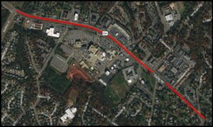
View the City’s project design presentation, which was finally linked from the project webpage on May 28, 2021, one workday before the June 1 project public comment deadline. View the project area on Google Maps.
The design of this relatively modest $8.4 million project—despite providing some much-needed and long-delayed pedestrian facilities—fails to make Manassas more livable, equitable, or sustainable, because it prioritizes excessively fast travel in motor vehicles over safe, pleasant, and effective non-auto mobility.
Moreover, the chronic lack of timely and impactful public involvement throughout the multi-year development of this City-led transportation project has squandered a valuable opportunity to help transform the City’s Sudley Medical character area into an attractive, mixed-use, walkable, healthcare-focused activity center, by ignoring or undermining the objectives, focus priorities, and design principles outlined on pages 56-58 in the Land Use chapter of the Manassas 2040 Comprehensive Plan.
An Abysmal Public Process
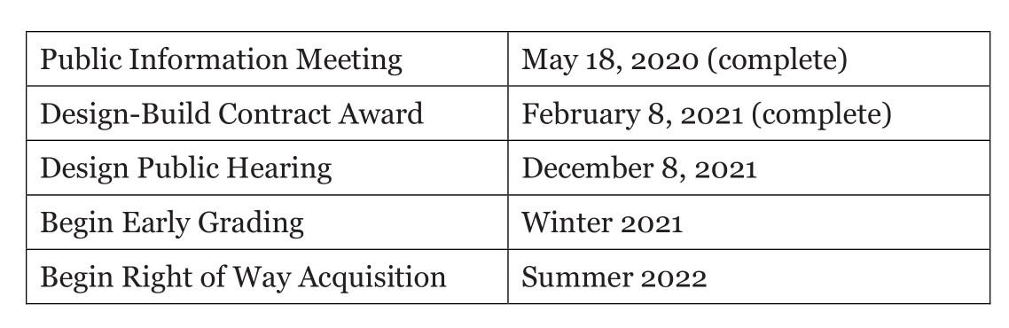
Although this project has been listed with a nutshell description in the City’s Capital Improvement Program (as project #T-015) since 2000, staff work apparently did not begin in earnest until the fall of 2015, when the project was submitted for the Commonwealth Transportation Board’s first round of SMART Scale (HB 2) funding (for FY 2017). On November 23, 2015, the Manassas City Council adopted a pair of resolutions to support the City’s transportation funding applications, but there was no prior public speaking opportunity.
Ideally, City staff should have begun engaging the community to discuss the scope of this long-planned transportation project at least six to 12 months before applying for any outside funding. However, the City had no transportation planner at that time, and the City departments responsible for Community Development and Planning and for Public Works and Engineering were siloed at separate locations.
In short, no community meeting or public hearing was ever held to discuss the scope, nature, or particulars of this project until City staff finally held a virtual public information meeting on Tuesday, May 18, 2021, when preliminary engineering was more than 90% complete. Had the City held such community conversations early and throughout project development, the scope and proposed design of this project would likely have been substantially better.
Originally, the southern terminus of this project was Dorsey Circle, the roadway widening was limited to the short segment between Rolling Road and Godwin Drive, and the scope included undergrounding the NOVEC electric wires on the east side of Sudley Road. However, in mid-2017, staff determined that the electrical undergrounding would cost more than extending the road widening farther south, to add a third northbound lane to Sudley Road between Grant Avenue and Stonewall Road.
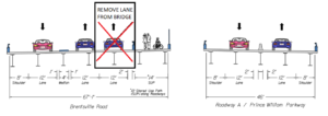
The northbound roadway between Stonewall Road and Rolling Road has long had an essentially continuous right-turn-only lane, as well as two straight-through-only travel lanes, and was never proposed for any additional widening (or sidewalk improvements).
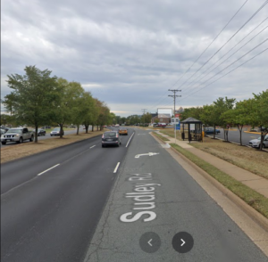
Google Streetview of Northbound Sudley Road across fron Novant/UVA Hospital. Except to allow through traffic in the rightmost lane, the Third Lane Project will not alter this road segment. The narrow, 4-foot sidewalk is only 2 feet from the roadway and without shade, street lights, or street furniture (except at this single, mid-block bus stop). The current continuous right-turn-only lane helps buffer the sidewalk from high-speed traffic and also provides bicycle access for traffic-tolerant bicyclists. The proposed Sudley Road Third Lane Project would essentially extend this pedestrian-hostile street design with three northbound travel lanes the full distance from Grant Avenue to Godwin Drive.
On December 11, 2017, City staff placed a change-of-scope request for this project on the consent agenda for the Manassas City Council. The project was re-scoped to create a continuous third northbound lane from Grant Avenue to Godwin Dr and to abandon all electric wire undergrounding. Again, there was no public comment opportunity, community meeting, or public hearing to discuss the re-scoped project, and the Council’s resolution approving the re-scoping falsely stated in part: “WHEREAS, the public involvement process is complete and all resulting comments have been addressed, as needed;”
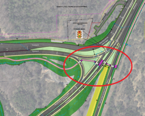
In February 2021, the project was quietly re-scoped again to add two extra turn lanes on Sudley Road at Godwin Drive for Prince William County’s proposed four-lane Route 28 Bypass in the Flat Branch floodplain. To accommodate the proposed Bypass, Prince William County has transferred $1.03 million in surplus federal highway (RSTP) funds from a recently completed highway project to the City’s Sudley Road project (see pp. 39-43 here). This time, not only was there no public comment opportunity, community meeting, or public hearing to discuss these project changes; the changes were not even mentioned on a City Council agenda. Instead, the fund transfer was discussed and approved at the February 11, 2021 meeting of the Northern Virginia Transportation Authority, with no public comment opportunity.
The Manassas City Council, as the policy-setting body for the City, has both the authority and a public duty to ensure early, continuous, robust, and impactful public involvement in the development of all City-led transportation projects going forward.
A Wasteful, Motorist-First, Pedestrian-Hostile,-and Bicyclist-Unfriendly Street Design
1) Sudley Road already has more than ample capacity for motor vehicles and lacks a traffic congestion problem that warrants a third northbound travel lane.
This two-way Sudley Road segment carries only 28,000 vehicles/day, a volume well accommodated with only four travel lanes, especially with dedicated left and right turn lanes at every intersection. By contrast, nearby Sudley Road in Prince William County carries 38,000 vehicles/day north of Godwin Drive and 50,000 vehicles/day north of Sudley Manor Drive. For comparison, Grant Avenue by Georgetown South, which the City seeks to squeeze into only two travel lanes, carries 16,000 vehicles/day, and southbound Sudley Road has only two travel lanes and no dedicated right-turn lanes south of Digges Road.
This project’s 2015 SMART Scale application scored very low for congestion-reduction benefits (see page 8 of the referenced application); over 90% of the project’s SMART Scale score (1.7 out of 1.9) was for “transportation-efficient land use” due to its location within a healthcare-focused mixed-use activity center that could be made more walkable and accessible via non-auto travel modes. In other words, SMART Scale funding was awarded because this project is located where enhanced walkabiity and non-vehicle access is important, not to address any traffic-congestion “deficiency”.
During the development of the City’s Transportation Master Plan (TMP) in 2019, existing arterial roadways and intersections throughout the City were analyzed by a traffic engineering consultant for traffic congestion, both at present and in the year 2040. As documented on pp. 11-13 of the TMP, Sudley Road has no existing traffic congestion problem between Grant Avenue and Godwin Drive, especially in the northbound direction. Furthermore, a similar analysis of roadway and intersection performance in 2040–in the absence of any currently non-programed transportation improvements–failed to identify any future traffic congestion problems along this segment of Sudley Road (see pp. 22-23 of the TMP).
Simply put, the repeatedly claims by City staff that this is project is “needed” to relieve traffic congestion and would “improve the capacity of northbound Sudley Road to accommodate vehicular traffic needs” is shear nonsense.
2) The proposed design is blatantly hostile to pedestrians. The project is designed to move motor vehicles at or above 45 MPH and would shift much of that fast traffic close to a narrow, poorly buffered sidewalk.
Each travel lane would be 12-feet wide, the standard for Interstate highways. Only one pedestrian crossing signal and marked crosswalk to cross Sudley Road is provided at each signalized intersection, and no mid-block pedestrian crossings or Sudley Road crossings at non-signalized intersections are accommodated. At many intersections, pedestrian-unfriendly free-flowing right turns are provided for vehicles entering Sudley Road from side streets. Higher vehicle speeds greatly increase the incidence and severity of traffic crashes, especially for pedestrians and other vulnerable road users.
This project will provide only narrow 4- or 5-foot sidewalks that are separated from the roadway with just a two-foot grass strip. Such narrow sidewalks poorly serve two-way foot traffic. Northbound Sudley Road lacks tree shade, urban street furniture, or pedestrian-scale street lights and offers only widely and irregularly spaced highway-style street lights. The design also lacks bus stops and bus shelters, except to preserve one mid-block bus shelter opposite the hospital. This project will not add or upgrade street trees, street lighting, street furniture, or bus stops. Those were not considerations.
The added lanes on Sudley Road at Grant Avenue, Rolling Road, and especially Godwin Drive would make crossing Sudley Road longer and more treacherous than if those lanes were not added.
3) The project design lacks promised and planned bicycle facilities which are both needed and eminently feasible.
Although the 2019 Manassas Transportation Master Plan calls for on-road bike lanes on Sudley Road (see maps on pp. 60-61 of the TMP), and project staff had promised to study the feasibility of adding a shared-use path (see page 62 here), the proposed design lacks bicycle accommodations. Furthermore, the project would eliminate the existing, continuous right-turn lanes that currently do accommodate traffic-tolerant northbound bicyclists. According to the Bicycle Network Recommendations Prioritization Matrix, conducted in 2019 as part of the development of the City’s Transportation Master Plan (Appendix E), installing bike lanes on this segment of Sudley Road (Grant Avenue to Godwin Drive) was tied as the most impactful bicycle network improvement identified for the plan.
Turning Lemons Into Lemonade
Since this project will likely be constructed with minimal design changes, two priority modifications merit immediate consideration. These two alterations would alter the current design by only changing some proposed pavement markings and roadway signs:
1) In lieu of the unnecessary and pedestrian-hostile third northbound travel lane, stripe and sign a continuous right-hand lane dedicated to right turns, buses, bicycles, and perhaps motor scooters.
2) Reduce the widths of the three 12-foot northbound travel lanes to 11 feet (or 10.5 feet if necessary) and reallocate 5 feet of roadway space to install bike lanes between the right-hand lane (described in #1 above) and the two straight-through travel lanes. To make ordinary striped bike lanes on Sudley Road reasonably safe, all right-turning traffic must be channelized in a right-turn-only lane to the right of the bike lane, and the vehicular design speed should be lowered toward 35 MPH, by narrowing the straight-through travel lanes and not expanding their number.
Of course, only a barrier-separated (“protected”) bike lane or an off-roadway shared-use path would provide a low-stress bikeway on Sudley Road serving the “interested, but concerned” “aged-eight-to-eighty” bicycling public. In addition, if striping similar bike lanes along southbound Sudley Road is not presently feasible beyond Digges Road, shared-lane markings (aka sharrows) might be a necessary, if less desirable, southbound alternative. However, neither a shared-use path nor a separated bike lane is politically or practically feasible under the current project, and the perfect should not be the enemy of the good.
How You Can Help
Public comments on the design of the Sudley Road Third Lane Project can be submitted at this link. The previously announced deadline for submitting those comments is Tuesday, June 1, 2021, but we have requested a two-week extension of that deadline.
There is no deadline to contact the Manassas Mayor and City Council to express your concerns with the project design and/or the awful public process. The Mayor and City Council are ultimately responsible for setting policies for the City, and they need to hear from their constituents that pedestrian-hostile street designs and the lack of early, robust, and proactive public involvement during the development and funding of City transportation projects are no longer acceptable.
###