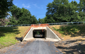
March 18, 2022 Update: The County has posted this followup video presentation on the proposed project design, and a virtual followup public meeting is scheduled for March 22 at 6 pm.
Several of our concerns with this project are currently being addressed (although the trail bridge over Rte 234 just east of the interchange is merely being “studied” at present).
However, all trail connections to and from Rte 234 Business and the long-planned future trail along Route 234 North would still require a two-step at-grade crossing of 12 signalized traffic lanes at the rebuilt intersection of Bradley Cemetery Way and Rte 234 Business, and two of the original six at-grade trail crossings of free-flowing highway ramps would remain. Those remaining design flaws would still create considerable delays and hazards for trail users.
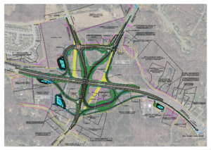
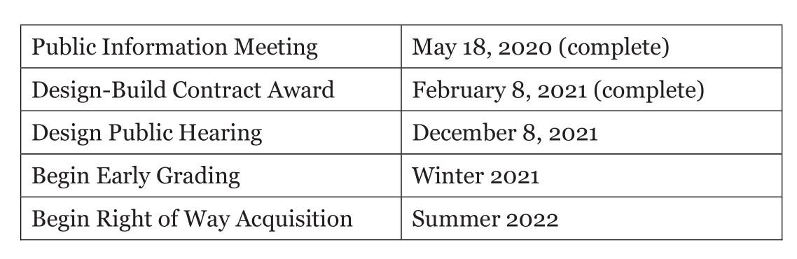
Active Prince William submitted the following public comments to the Prince William County Department of Transportation in response to its December 8, 2021 Design Public Hearing on its proposed Interchange at Route 234 and Brentsville Road. The public comment period closed on December 18, 2021.
The advertised design of the above-referenced project does not safely and effectively accommodate people bicycling, walking, or using other active transportation modes through the project area. The design of the advertised non-motorized connections should be revised substantially to provide reasonable access and safety for people who are not traveling inside motor vehicles.
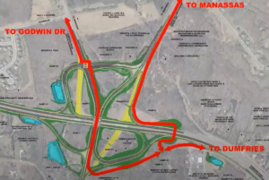
1) The Proposed Design Includes Too Many Dangerous At-Grade Trail Crossings of Free-Flowing, High-Speed Highway Ramps
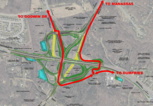
This interchange is the connection point for Prince William County’s two major east-west cross-county shared-use paths; namely, the asphalt sidepaths along Route 294 (Prince William Parkway) and Route 234 South (Dumfries Road). While the proposed design does include a circuitous shared-use path, meandering through the center of the interchange, that links both major paths, this advertised path connection would require people walking or bicycling to cross five separate at-grade crossings of high-speed highway ramps without any protection from traffic signals. This tortuous path connection is not merely long, indirect, slow, and tedious; it is extremely hazardous and will both significantly deter trail use and lead to multiple pedestrian and bicycling injury crashes and eventually to traffic deaths.
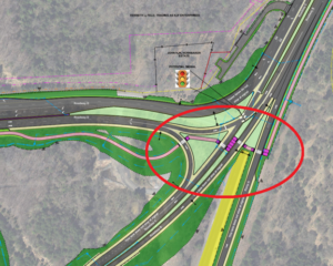
Four of the six at-grade trail crossings of free-flowing, high-speed highway ramps that are included in the advertised design
Since this proposed interchange would create near-Interstate-highway-quality, free-flow connections for motor vehicles from all five approaches, it is unconscionable to have any at-grade trail-roadway crossings in this project.
Rather than connect the two existing major trails via five at-grade highway ramp crossings within the center of the interchange, bicyclists and pedestrians should instead be routed near the eastern and northern perimeters of this interchange via pedestrian/bicycle overpasses of three legs of this intersection; namely, Route 234 South, Route 294, and Route 234 Business. While all three pedestrian/bicycle overpasses proposed below are clearly warranted for safe and equitable access, they are listed above in priority order.
With that said, the trail approaches to many of the proposed at-grade roadway crossings in the present design are often very short and nearly parallel to the crossed roadway, especially at most of the four at-grade roadway crossings near the intersection of Bradley Cemetery Way and Route 294. With such closely spaced crosswalks and sharply bent trail approaches, a bicycle rider would need to fully stop well before reaching the crosswalk, dismount, and manually reposition her bicycle to clearly view the approaching cross-traffic, and she will thus require much larger gaps in traffic to safely cross each roadway ramp. The clustering of some of these crosswalks and the resulting short path segments between them would also likely create conflicts and collisions with any trail users approaching from the opposite direction. If the final design retains any at-grade roadway crossings, the trail approaches should be as perpendicular to each crossed roadway (or in direct line with each crosswalk) as possible and substantially longer than the crosswalk itself.
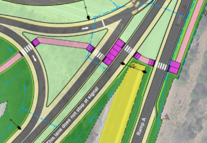
The advertised design includes four closely spaced at-grade path crossings of free-flowing highway ramps near Route 294
The proposed shared-use path junction for the sidepath along Brentsville Road, near the southern end of the intersection, is also poorly designed. The approach of the Brentsville Road sidepath to the Ramp C crossing is far too close and nearly parallel, not perpendicular, to Ramp C. In addition, the Brentsville Road sidepath joins the longer path leading to Route 234 South at a sharp 90-degree angle, rather than making gentle Y-shaped connections much farther east of Ramp C. The latter design flaw is replicated at the path junction near Bradley Cemetery Way and Route 234 Business. Published AASHTO and VDOT guidance describe how to design appropriate path connections for people riding bicycles at 15 to 20 MPH.
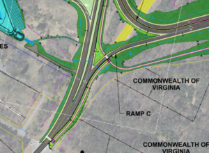
The sidepath along Brentsville Road is poorly designed at its northern end near the Ramp C crossing.
2) Separating Shared-Use Paths from High-Speed, Free-Flowing Vehicle Traffic is a Long-Standing Practice in Northern Virginia
The practice of designing and building high-quality shared-use paths along and/or across limited-access highways without any at-grade road crossings has at least a 40-year history in Northern Virginia. When the Virginia Department of Transportation designed and built I-66 in Arlington circa 1980, it established a continuous 10-foot asphalt path immediately adjacent to that highway with zero at-grade roadway crossings for the more than four miles between N Scott St in Rosslyn and the City of Falls Church at N Van Buren St and Route 29.
The 45-mile Washington & Old Dominion (W&OD) Trail, which runs from Shirlington to Purcellville, is Northern Virginia’s preeminent active transportation and recreation facility, largely because it has zero at-grade crossings of fast or busy roadways that are not protected with traffic signals.
In Arlington, the W&OD Trail benefits from both local roadway overpasses of the adjacent I-66 to cross under N. Ohio St and N. Patrick Henry Dr and stream underpasses for the adjacent Four Mile Run to cross under N. Sycamore St, N. Wilson Blvd, N. Carlin Springs Rd, and Arlington Blvd. As a result, the W&OD Trail has zero at-grade roadway crossings for the nearly four miles between Columbia Pike and the Falls Church line at N Van Buren St.
For at least the past 30 years, NOVA Parks (formerly NVRPA) has required all builders of new or widened roads across its W&OD Trail to include a grade-separated crossing for the trail. As a result, the W&OD Trail west of Four Mile Run now includes more than two dozen separate trail overpasses or underpasses at Route 29 in East Falls Church, Route 7 in Falls Church, I-495, American Dream Way, Reston Parkway, Town Center Parkway, Fairfax County Parkway, Herndon Parkway East, Center St in Herndon, Herndon Parkway West, Church Road, Atlantic Blvd, Route 28/Sully Road, Pacific Blvd, Loudoun County Parkway, Ashburn Village Blvd, Claiborne Parkway, Belmont Ridge Road, Battlefield Parkway SE, Route 15, Plaza St SE, Route 7/Harry Bryd Hwy, the Route 9/Route 7 Interchange, and the Route 287/Route 7 Interchange. Many of those grade-separated roadways have lower traffic speeds and/or volumes than Routes 234 and 294.
Currently, the I-66 Outside the Beltway Express Lanes Project is in the process of building 11 miles of shared-use paths adjacent to I-66 in Fairfax County, as well as safe bicycle and pedestrian facilities on nearly all of the roads that cross I-66. These new bicycle and pedestrian connections have been carefully and creatively designed to avoid at-grade roadway crossings, especially crossings with free-flowing, high-speed traffic.
Operated by the National Park Service’s George Washington Memorial Parkway unit, the 18-mile Mount Vernon Trail between Rosslyn and the Mount Vernon Estate is another premier shared-use path in Northern Virgina. Because it follows the Potomac River, the Mount Vernon Trail has always had few at-grade road crossings. Nevertheless, many millions of dollars have been invested over the years to remove busy at-grade highway ramp crossings near Reagan National Airport, and—with no highway ramp interruptions—to connect the Mount Vernon Trail to Rosslyn, the Pentagon, and Crystal City and to cross the Potomac River on the Woodrow Wilson Bridge.
In recent years, the Virginia Department of Transportation has been building a network of pedestrian and bicycle overpasses of I-495 and the Dulles Toll Road in the Tysons area, including along Route 7 across the Dulles Toll Road, Trap Road over the Dulles Toll Road in Vienna, the Jones Branch Connector over I-495 south of the Dulles Toll Road in McLean, and the Tysons One/Old Meadow Road overpass of I-495 near Pimmit Hills.
Bicycling and walking are viable transportation and very popular recreation modes in communities with high-qualify shared use paths, and the absence of at-grade highway ramp crossings is a key contributor to the safety, use, and enjoyment of those paths. Prince William County will never create the types of high-quality paved trails enjoyed in most other Northern Virginia localities if it continues to build shared-use paths with hazardous at-grade crossings of highway ramps.
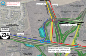
3) Install a Pedestrian/Bicycle Bridge over Route 234 on the East/South Side of the Interchange to Create a Safe and Direct Connection between the Route 234 and Route 294 Paths
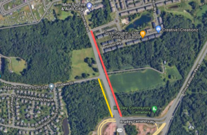
The Route 234 and Route 294 sidepaths–the two major existing bike/ped facilities within the project area—could be linked very safely and directly by building a pedestrian/bicycle bridge between these two trails on the east/south side of the interchange in the vicinity of the Meadows Farms Garden Center. Because the elevation on the south side of Route 234 is considerably higher than the roadway, no long bridge approach should be needed on that side of the overpass.
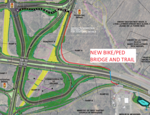
Our proposed direct connection of the existing Route 294 and Route 234 shared-use paths via a pedestrian/bicycle overpass of Route 234 on the east side of the interchange near the Meadows Farms Garden Center
4) Incorporate Safe and Direct Connections to and from Route 234 Business (Dumfries Road) and the Planned Trail along Route 234 North
Even if the direct pedestrian/bicycle bridge requested above is built, safe and efficient bicycling and walking connections would still be needed to and from all five legs of this interchange; namely Route 294 (Prince William Parkway), Route 234 South (Dumfries Road), Route 234 North (Prince William Parkway), Brentsville Road (Route 649), and Route 234 Business (Dumfries Road).
Although the current Prince William County Comprehensive Plan calls for building a major shared-use path along Route 234 North, the current project design does not depict this future trail or its connections to the four other legs of this interchange. The current design should be modified to identify the right-of-way and connections for the future Route 234 North shared-use path within the project limits.
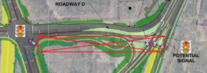
Presently, Route 234 Business (Dumfries Road) provides bicycle and pedestrian access to the project area from most of the City of Manassas, the Bradley Square development, and the Godwin Drive corridor. Bicyclists and pedestrians now readily use Route 234 Business to access Brentsville Rd, the Route 234 South sidepath, and the Route 294 sidepath via the roadways and crosswalks at the two nearby existing Route 234 intersections (and alternatively via Bradley Cemetery Way if desired).
The proposed design, however, would severely degrade this walking and bicycling access to and from Route 234 Business by expanding the limited-access control perimeter and by creating a large new signalized intersection at Route 234 Business and Bradley Cemetery Way. To access any other leg of the interchange, bicyclists and pedestrians from Route 234 Business (and also the future shared-use path along Route 234 North) would apparently need to 1) cross two separate legs of a large, signalized Route 234 Business/Bradley Cemetery Way intersection—spanning a total of 12 vehicle lanes—2) cross a free-flowing lane of right-turning traffic from northbound Brentsville Road, and 3) finally cross either one or four-additional high-speed highway ramps within the center of the interchange, depending upon one’s destination. This proposed pedestrian and bicycle access is neither safe nor effective and is a significant degradation of the existing conditions.
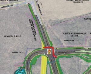
The advertised design would require at least a four-stage maneuver for pedestrians and bicyclists using Route 234 Business (or the future shared-use path along Route 234 North) to access any other leg of this interchange: 1) cross five lanes of stopped traffic at Route 234 Business, 2) cross seven lanes of stopped traffic at Bradley Cemetery Way, 3) cross one-lane of free-flowing right-turning traffic from northbound Brentsville Road, and 4) cross either one or four additional highway ramps—located elsewhere inside the interchange–with free-flowing, high-speed traffic, depending upon one’s final destination.
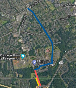
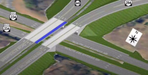
The current design should be modified to add an elevated trail on a berm along the north side of Bradley Cemetery Way, with pedestrian/bicycle bridges over both Route 234 Business and Route 294. Such an elevated trail would connect the existing Route 294 path with the west side of Route 234 Business and the long-planned future trail along Route 234 North. Placing this trail connection on a berm along the north side of Bradley Cemetery Way should lower construction costs and improve walking and bicycling conditions by minimizing grade changes along this trail connector between the pedestrian bridges over Route 294 and Route 234 Business. Integrating these safe and direct grade-separated trail connections as part of the current project should provide them at far lower cost than if constructed later as one or more standalone projects.
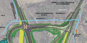
Rough alignment of our proposed grade-separated trail connections along the northern perimeter of the interchange, with two relatively short pedestrian/bicycle overpasses of Route 234 Business on the west (connected to future shared-use paths along Route 234 Business and Route 234 North) and Route 294 on the east (connected to the existing Route 294 shared-use path). Between Route 234 Business and Route 294, the connecting path could be built on a berm along the north side of Bradley Cemetery Way.
5) Reduce Interchange Construction Costs by Eliminating Unnecessary Trail and Roadway Features
To offset the cost of adding up to three pedestrian/bicycle bridges, the current design could be modified to eliminate unnecessary features.
If all three pedestrian/bicycle bridges recommended above are built over the eastern and northern edges of this interchange, all currently designed pedestrian/bicycle infrastructure within the center of this interchange would be unnecessary and could be eliminated, including the currently proposed 14-foot-wide shared-use path on the western interchange bridge.
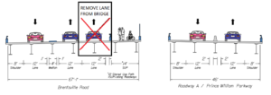
The cost of the western interchange bridge should be further reduced by eliminating the advertised continuous green-T intersection at the exit ramp from southbound Route 234 and by eliminating one of the two northbound travel lanes from Brentsville Road on the western interchange bridge. Traffic volumes on Brentsville Road, which had an AADT of only 2800 in 2019, will never warrant two northbound lanes through this interchange. Eliminating one unnecessary travel lane (and potentially also the shared-use path) would reduce the cost of this roadway bridge considerably. A traffic signal, stop sign, or a roundabout could replace the proposed continuous green-T intersection.
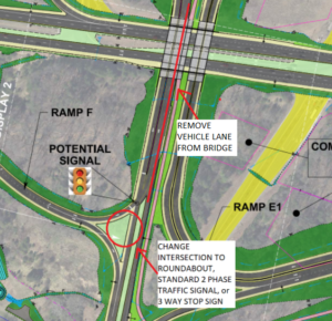
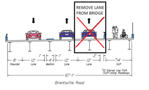
To reduce project costs, one northbound lane from Brentsville Road could be eliminated on the western overpass. This second northbound lane is not warranted by current or future Brentsville Road traffic volumes and was only designed to accommodate an unnecessary continuous green-T intersection for traffic exiting southbound Route 234. If the advertised design is modified to add all three pedestrian/bicycle overpasses recommended above, the 14-foot wide shared-use path could also be eliminated from this overpass. The width of the advertised western overpass could thus be reduced 39%, from 67 feet to 41 feet.
Reducing northbound Brentsville Road to a single lane though the interchange would also reduce the widths of the roadway north of the western overpass and the width of the signalized intersection of Brentsville Rd/Route 234 Business at Bradley Cemetery Way.
The Route 234 Business/Dumfries Road roadway is already needlessly wide south of Godwin Drive. According to VDOT’s 2019 traffic count data, this roadway segment has an AADT of only 8600. Presently, the Route 234 Business roadway south of Godwin Drive is five lanes wide, whereas only three lanes of roadway (one travel lane per direction plus space for a left-turn lane in the center) would adequately accommodate a future doubling of this Route 234 Business Traffic (i.e., to an AADT of 17,200).
Rebuilding Route 234 Business between Godwin Drive and Bradley Cemetery Way as a three-lane roadway, instead of as a five-lane roadway, would allow the addition of both a shared-use path and a sidewalk within the existing right-of-way along this key road segment. Moreover, the shared-use path (and not the sidewalk) should be located along the west side of Route 234 Business to align with the west-side path just built within the City of Manassas between Hastings Drive and Donner Drive.
Thank you for considering these comments. We look forward to seeing a substantially modified final design for the shared-use path connections that will eliminate all at-grade roadway crossings and accommodate safe and reasonably direct pedestrian and bicycle access to and from all five legs of this key interchange.
On December 27, 2021, we submitted the following additional comment:
Building 12-foot-wide travel and turn lanes on Brentsville Road, Route 234 Business, and Bradley Cemetery Way is clearly excessive, since 11-foot-wide lanes are more than adequate for those local, lower-speed roadways. Designing 11-foot travel lanes on the Brentsville Road bridge over Route 234 would further lower the cost of building that overpass. With 8-foot-wide paved shoulders included on that overpass, 12-foot-wide travel lanes are most definitely wider than needed.
A narrower Route 234 Business on the north side of Bradley Cemetery Way would also reduce the cost of a pedestrian and bicycle overpass at that location and would shorten pedestrian crossing times if at-grade crosswalks are still included at Route 234 Business and/or Bradley Cemetery Way in the final design.
###