Advancing active mobility in greater Prince William, Virginia

Tag: Prince William County (Page 1 of 2)

Hoadly Road Needs Proper Bike Lanes

We recently learned that the Prince William County Department of Transportation will soon conduct a Hoadly Road Planning Study to identify priorities for funding and then building segments of a continuous shared-use path (i.e., a 10-foot wide asphalt sidepath) along Hoadly Road, between the Prince William Parkway (Route 294) and Dumfries Road (Route 234).  Hoadly Road currently lacks any sidepath, except along the 0.4-mile segment between Dale Boulevard and Spriggs Road.

Active Prince William strongly supports establishing a continuous sidepath along at least one side of Hoadly Road, especially since such shared-use pedestrian facilities would link Prince William County’s two major sidepaths–along Routes 234 and 294.

However, the Mobility Chapter of the current Prince William County Comprehensive Plan (Pathways to 2040), which the Board of County Supervisors adopted in December 2022, is deficient in not also calling for on-road bicycle lanes along Hoadly Road (see page 73 here).

There is no inherent reason why highway corridors should include only one type of bicycle facility–e.g., only a sidepath–especially since conventional bike lanes can be retrofitted on multi-lane roadways much more quickly and inexpensively and since having both on-road and off-road bicycle facilities could best serve our highly diverse population of bicycle riders.   In addition, bike lanes are more readily and promptly cleared of snow and ice after winter storms.

Furthermore, bike-lane retrofits have the added benefits of reducing motorist speeding (by reducing travel lane widths) and of increasing the safety and comfort of people traveling on the sidewalks or sidepaths (by increasing the noise and wind buffer from vehicular traffic).

Hoadly Road currently has an excessively high design speed, a posted speed limit of 50 MPH, and poor pedestrian infrastructure.  Consequently, according to Virginia’s publicly searchable traffic crash database, over the past decade (2014-2023 calendar years), Hoadly Road was the site of 403 traffic crashes, 310 crash-associated injuries, and 4 traffic fatalities.  Retrofitted bike lanes on Hoadly Road would help alleviate those unsafe conditions for all modes of travel.

When widened some decades ago, Hoadly Road gained continuous wide paved shoulders that were well suited for bicycling, and at least some of those shoulder segments were subsequently marked as bike lanes.

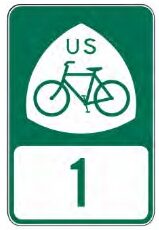
US Bicycle Route 1 (USBR 1) is a Maine-to-Florida bicycling route–primarily intended for experienced bicycle travelers–that has existed for decades.  USBR1 in Virginia, upon VDOT’s written application, was designated by the American Association of State Highway and Transportation Officials (AASHTO) back in 1982, more than 40 years ago.  Although USBR1 through Prince William County was originally aligned with Minnieville Road, between Old Bridge Road and Dumfries Road, VDOT and Prince William County largely failed to include appropriate bicycle facilities along much of Minnieville Road during the ensuing decades. as segments of Minnieville Road were sequentially widened to accommodate increased development and traffic.

More than a decade ago, VDOT commissioned a study by a transportation consulting firm to re-evaluate the routing of US Bicycle Route 1 through Northern Virginia, including Prince William County.  As a result of that study, USBR1 was officially realigned to follow a segment of the Prince William Parkway and all of Hoadly Road, to avoid the segment of Minnieville Road north of Cardinal Drive that still lacks bicycle facilities.

As noted on page 11 of that USBR1 realignment study report (emphasis added below):

Although less direct than the other alternatives, the recommended alternative (via Minnieville Road, Prince William Parkway, and Hoadly Road) offers a higher average BLOS [Bicycle Level of Service] (B), primarily the result of lower ADT [average daily traffic] and wider shoulders. The route segment along Minnieville Road and Prince William Parkway has high ADT (up to 45,000 vehicles per day), but also provides shared use paths or wide shoulders for much of the duration. Meanwhile, Hoadly Road has approximately 13,000 to 23,000 vehicles per day and provides 8‐foot shoulders along many segments.

Google Street View reveals that various segments of Hoadly Road currently do have marked bike lanes, but these are discontinuous and often inappropriately situated on the right side of long right-turn-only lanes, such as here, here, here, and here.   Glaring deficiencies in Hoadly Road’s “bike lanes” were noted by a resident back in 2010 [mislabeled a “bike path” in that blog post].

Since the entirely of Hoadly Road has been the designated alignment of US Bicycle Route 1 for nearly the past decade, Active Prince William asks that VDOT and Prince William County proactively collaborate to retrofit continuous and well-designed bike lanes–and, ideally, buffered or separated bike lanes–along all of Hoadly Road at the earliest possible opportunity.

We also recommend adding the planned Hoadly Road sidepath as a designated segment of the National Capital Trail Network (NCTN) when the National Capital Region Transportation Planning Board again updates its NCTN map in the coming year.

Design Public Hearing for PWC’s Route 234-Brentsville Road Interchange Project, December 8, 2021 at 6:00 PM

Prince William County’s proposed Route 234-Brentsville Road Interchange includes four treacherous at-grade shared-use path crossings of free-flowing high-speed roadways to link the Prince William Parkway and Route 234 sidepaths.   As an alternative to this dangerous and circuitous trail routing, Active Prince William advocates a simple trail overpass on the east/south side of this interchange to safely and directly link Prince William County’s two major trails.


From the Office of Coles District Supervisor Vesli Vega:

A public hearing on the proposed Brentsville Interchange Project will be held on Wednesday, December 8th at 6pm at the Lake Jackson Volunteer Fire Department, 11310 Coles Drive in Manassas.

The meeting can also be viewed live online at https://www.pwcva.gov/department/transportation/current-road-projects.  The Project team will make a short presentation beginning at 6:30 p.m. and answer questions for the duration of the meeting.

The purpose of the public hearing is to receive public comments on the design of the Route 234 Brentsville Road Interchange Project and associated Limited Access Control Changes in the Coles Magisterial District.  This Project will involve a change and break in Limited Access Control.

Preview the Project information and Design Public Hearing plans including the environmental documentation on the Prince William County Department of Transportation website at https://www.pwcva.gov/department/transportation/current-road-projects.  [Note: The five linked documents related to the current design are listed at the bottom, with links depicted in green.  The blue links are for the obsolete March 2020 design].

The deadline to submit comments is December 18, 2021.  The public may provide written or verbal comments at the Design Public Hearings, mail them to Ms. Mary Ankers, P.E., Project Manager, at the Prince William County Department of Transportation, 5 County Complex, Suite 290, Prince William, VA 22192, or email them to [email protected].   Please reference “Route 234 Brentsville Road Interchange Project PH Comments” in the subject heading.

Please find the Project Schedule Below:

APW Urges Its TPB Members to Ensure New Transportation Plans Meet Climate and Equity Goals


On June 15, 2021–in advance of the June 16 meeting of the National Capital Region Transportation Planning Board (TPB) at which the project submissions for updating Visualize 2045, the region’s long-range transportation plan, were scheduled for adoption –Active Prince William sent the following message to Prince William County’s two representatives on that regional transportation planning body–Prince William Board of County Supervisors Chairman Ann Wheeler and Neabsco District Supervisor Victor Angry.   We also sent similar messages to the TPB members who represent the Cities of Manassas and Manassas Park–Manassas Vice Mayor Pamela Sebesky and Manassas Park Mayor Jeanette Rishell.

Here’s a summary of the contentious June 16, 2021 TPB meeting, at which a proposal to craft a climate-friendly regional transportation plan for adoption  by 2024 was agreed to


The National Capital Region Transportation Planning Board (TPB) will be taking up a resolution at their June 16th meeting regarding a Visualize 2045 Alternative Build Scenario that would aim to achieve TPB climate and equity goals through the use of transportation demand management, transit, and land use strategies consistent with regional policy goals, a modified regional project list that reduces the number and scale of road capacity expansion projects in accordance with anticipated reduced travel demand, and with particular focus on public transportation and pedestrian/bicycle improvements needed to serve mobility disadvantaged populations.  This is being brought forward because the recently submitted project updates to Visualize 2045 will not meet the TPB climate and equity goals.

Due to the time and resource constraints at this point in the Visualize 2045 update process, Active Prince William recommends Prince William County support the following action plan to support meeting TPB climate and equity goals:

1)    Commit to completing the TPB Climate Change Mitigation Study and review it thoroughly at the regional and jurisdictional levels through the first quarter of 2022.

2)    Formally commit to assisting the TPB to develop a set of transportation policies and projects, by the end of 2022, which would be implementable at the jurisdictional and regional levels, consistent with the recommendations of the Climate Change Mitigation Study, that, when fully implemented will assure the region will meet its climate change mitigation goals

3)    Commit to take actions to officially adopt the projects and policies developed to attain the region’s climate goals within the transportation sector, and advance these projects into the region’s LRTP for a mid-term update to be completed in 2024

As voting members of the TPB, this is an opportunity for Prince William County to be a transportation planning leader as it relates to climate and equity in the region.   Supporting this initiative aligns with PWC BOCS Resolution 20-773: Regional Climate Mitigation and Resiliency Goals and the Prince William County Equity and Inclusion Policy.

The updated mobility chapter of the comprehensive plan should be aligned with this action plan.  Prince William County should also advocate these measures be included as the starting point for the next NVTA Transaction Plan.  To support this the Prince William County should advocate that the General Assembly act to modify the NVTA statute to align with your climate and equity goals.

The climate is not waiting. The time to act is now.

Our Comments on the Thoroughfare Plan Element of the Mobility Chapter in the PWC Comp Plan Update

On June 16, 2021, Active Prince William submitted the following general and specific comments on the Thoroughfare Plan Element of the Mobility Chapter in Prince William County’s Pathways to 2040 Comprehensive Plan


Comments on the Thoroughfare Plan Element of the Mobility Chapter in Prince William County’s Pathways to 2040 Comprehensive Plan

Active Prince William encourages Prince William County to refine its Thoroughfare Plan to support its climate and equity goals.  Please see the attached granular comments on each item in the Thoroughfare Plan that provide a more realistic plan to achieve by 2040.  Below are a few highlights.

  1. Dedicated bus lane infrastructure (Bus Only/BAT[Business Access and Transit]) should be planned for many major roadway arterials (ex. Route 1, Route 234 Business, Dale Blvd, Route 29)
  2. Roadway segments should be identified as “innovative intersection corridors” to replace previously planned lane-mile expansions (ex. Old Centreville Rd, Pageland Ln, Route 234, Prince William Parkway)
  3. Roadways through activity centers and commercial/mixed-use corridors should be redesignated as Urban Boulevards (UB) and Through Boulevards (UTB) (ex. Route 123 and Route 1 in North Woodbridge)
  4. Road diets should be considered for many roadway segments (ex. Occoquan Rd, Williamson Blvd, Lee Hwy/MNBP)
  5. Road capacity expansion should be configured as a managed lane (Toll, HOV, HOT, Bus, BAT). Adding any new unmanaged roadway capacity in the Washington region is unproductive at this point as it relates to future climate and congestion conditions and will only serve to induce SOV travel and increase VMT per capita.
  6. Major “managed lanes” roadway widenings should be packaged with dedicated bus infrastructure on nearby parallel roadways  (234 Bypass -> 234 Business, I-95 HOT ->Route 1)

Click here for our detailed comments on each roadway element in the Thoroughfare Plan.

Our General Comments on Active Mobility and Trails for the Mobility Chapter in the PWC Comp Plan Update

On June 16, 2021, Active Prince William submitted the following general comments on the active mobility and trails element for the Mobility Chapter in Prince William County’s Pathways to 2040 Comprehensive Plan:


Active Prince William’s General Comments on the Active Mobility and Trails Element of the Mobility Chapter in Prince William County’s Pathways to 2040 Comprehensive Plan

1. Active Prince William encourages Prince William County to plan for the expeditious development of a robust, connected, and diverse countywide network of bikeways, walkways, and trails as part of the Mobility Chapter of the Pathways to 2040 Comprehensive Plan.

2. The County should invest in building more “active transportation” infrastructure through 2040 to rebalance the excessive car-centric focus of the past.  A robust, countywide Bicycle and Pedestrian Mobility Plan should be created to identify and prioritize bikeways and walkways that connect all activity centers and provide safe routes to all schools, parks, recreation centers, libraries, transit hubs, shopping centers, and employment sites, so bicycling, walking, and rolling can increasingly replace many short-distance (under 5-mile) motoring trips

3. The Bicycle and Pedestrian Mobility Plan should identify where various types of bikeways, trails, and sidewalks will be completed by 2040.  One goal, synchronized with the Parks, Recreation and Tourism Chapter and the Systemwide Master Plan for county parks, should be to create a connected network of shared-use paths, sidewalks, and bikeways, so all neighborhoods with a density of 4 or more dwelling units/acre are within a 10-minute walk (1/2 mile) of a neighborhood park or school/community-use site.

4. The County should establish a more vigorous and ongoing Active Transportation Program within its Department of Transportation, guided by a comprehensive and strategic Bicycle and Pedestrian Mobility Plan adopted by the Board of County Supervisors. The development of that plan, which could require a year or more of effort and community outreach, should be guided by dedicated in-house transportation planning staff and a diverse citizen task force. An outside consulting firm with strong expertise in active mobility planning (e.g., Toole Design Group or Alta Planning + Design) should be hired to coordinate the development of this Bicycle and Pedestrian Mobility Plan.

5. Formal Complete Streets and Vision Zero policies and action plans–adopted by the Board of County Supervisors following substantial public input–could help guide the County’s development of active mobility infrastructure.

6. The Mobility Chapter should include a table listing specific planned bicycle, pedestrian, and trail facilities, comparable to Table 2 listing the Thoroughfare Plan projects.

7. Appropriate bicycle and pedestrian accommodations should be planned and aggressively implemented, both as an integral component of all roadway widening and reconstruction projects and as standalone projects actively pursued separately from roadway reconstruction, during both scheduled roadway resurfacing and as fully independent projects.

8. A strategic prioritization process should guide the implementation of the standalone bicycle and pedestrian projects. The prioritization process for standalone projects and retrofits should consider many factors, with “opportunity” (such as upcoming roadway resurfacing, grant availability), trip demand, cost effectiveness, equity, and pedestrian safety being key considerations.

9. Bicycling accommodations for collector and arterial road corridors and urban boulevards should not be largely limited to shared-use paths (sidepaths), which are often hillier, more meandering, and less well maintained than the adjacent roadway and frequently interrupted by hazardous motor vehicle cross flows at intersections and driveways. These features make sidepaths much slower and more stressful for bicycling than simply sharing the roadway with vehicular traffic.

10. Whenever feasible, dual bicycling accommodations–both off-roadway (sidepath) and on-roadway (bike lanes, separated bike lanes, paved shoulders, or signed shared roadways)–should be provided to serve the diversity of people who ride bicycles.

11. Roads with Average Annual Daily Traffic (AADT) less than 1,000 vehicles/day generally require no special accommodations for bicycling enthusiasts.

12. Adding paved shoulders (on open-section roadways) or bike lanes (on closed-section roadways with curb and gutter) is appropriate for road cycling enthusiasts and can provide very suitable bicycle accommodations, particularly in the Rural Area.  As traffic speeds and/or volumes increase—and for roads along a designated bike route– the need for (or desirability of) wider paved shoulders or bike lanes or for more separation between the bike lane and the adjacent travel lane (with either a crosshatched buffer or a physical barrier) increases.

13. The Mobility Chapter should include a policy that when the traffic volumes on roads in the Rural Area rise above 1,000 vehicles/day, VDOT will be asked to retrofit modest (2- to 4-foot wider) paved shoulders during scheduled roadway resurfacing, retaining the original 30-foot prescriptive easement. Such modestly widened roadways could then be striped with two 10-foot travel lanes flanked by two 5-foot paved shoulders for walking and bicycling.

14. When any residential development involving 10 or more homes is permitted beside a road without a sidewalk, the developer should be required to build a sidewalk or a sidepath along the road frontage for that subdivision.

15. On roadways where traffic volumes are forecast to exceed 10,000 vehicles/day over the next 20 years, adding a central two-way left-turn lane as well as paved shoulders or bike lanes should be proposed, as an alternative to widening to four or more travel lanes.

16. Roads planned for “Class II” bikeways should be identified as planned for “sidewalks plus bike lanes,” or just for paved shoulders or bike lanes.

17. The current designation for 14-foot “wide” outside lanes (termed “Class III” bikeways) should be eliminated. All of those roads should be re-designated for bike lanes (aka “Class II” bikeways). If multilane roads are simply striped with 11-foot travel lanes instead of the Interstate-regulation 12-foot travel lanes, a 14-foot outside lane becomes at least 16 feet wide, which is wide enough to allocate as a 5-foot wide bike lane plus an 11-foot travel lane.  Thus, the category of “wide outside lanes” is not only a poor bicycling accommodation; it’s a completely unnecessary category.

18. Signed shared roadways (e.g., relatively low-speed collector roads with shared-lane markings (a.k.a. “sharrows”) or low-traffic residential subdivision streets with way-finding signs) are the only “Class III bikeways” that should remain.

19. Signed shared roadways should be planned only where traffic speeds and volumes are relatively low, and bike lanes are either infeasible or unnecessary due to low traffic speeds and volumes.  This category should be designated as “Sidewalks and Shared Roadways”, rather than as “On-Road Trails.”

20. The Vision Zero strategies appropriate for different areas in Prince William should be identified and incorporated in all transportation planning.  Crashes involving a vehicle with a bike or pedestrian should be reported as a “vehicle-bike crash” or “vehicle-pedestrian” crash, not as “bike crash” or “pedestrian crash”.  Since vehicle speed greatly influences the severity of such crashes, VDOT and the County Department of Transportation should seek to lower the design speeds and posted speed limits on roads within activity centers, and emerging technologies, such as automated speed enforcement, should be used to reduce speeding. Particular attention should also be paid to minimizing risk when designing intersections that permit right turns on red and intersections where people walking or bicycling must cross two or more lanes of free-flow traffic.

21. Since transportation is our largest source of greenhouse gas emissions, and Prince William has committed to reduce these emissions by 2030 to 50% of the 2005 level, the County should quantify the greenhouse gas emission impacts of proposed new transportation projects, including trails, for the county’s Climate Action Plan.

22. For shared-use paths, bike lanes, and sidewalks maintained by the county, rather than VDOT or an HOA, the PW County Departments of Transportation and of Parks, Recreation and Tourism should budget annually for routine maintenance as well as for capital maintenance (e.g., periodic repaving).  That includes removing storm debris, managing winter snow and ice, mowing grass, and removing encroaching vegetation.

23. For Traffic Impact Analyses, the county should report average pedestrian delay at intersections together with reports of average vehicle delay, and calculate bicycle and pedestrian Levels of Service and/or Comfort, comparable to calculating Level of Service for Vehicles.  Intersections should be designed to balance delays for bicyclists/pedestrians as well as delays for vehicles.

« Older posts