As part of the ongoing Comprehensive Plan update, the Prince William County Planning Office has created several small area plans to guide development in key areas of the county. Each small area plan may offer opportunities for improved transit, increased open space, and greater walkability.
Public outreach will be accomplished through one or more public meetings and design charrettes for each project. A charrette is a collaborative planning session among a project’s various stakeholders – in this case, government officials, consultants and/or developers, and interested members of the public. A planning outline and some anticipated outcomes are provided for each active plan at the links below. There are no upcoming public hearings or charrettes currently scheduled, but the Planning Department promises to update the website when they have been. We will monitor the website as well.
Five plans that are currently active:
Dale City
The basis for this project is two studies completed earlier this year: one by the Dale City Sustainable Design Assessment Team (SDAT) and the other under a Metropolitan Washington Council of Governments (MWCOG) Transportation/Land-Use Connections (TLC) Program grant. The scope of the studies includes redevelopment of both the Dale Boulevard/Minnieville Road intersection and Mapledale Plaza at the intersection of Dale Boulevard and Queensdale Drive, as well as extensive redesign of vehicular, cycling, and walking infrastructure throughout the area.
Innovation Park
An examination of the Innovation Park area and a couple of miles of Prince William Parkway between Sudley Manor Drive and Godwin Drive/Nokesville Road, with the goal of developing Innovation Park as an economic center for PWC.
North Woodbridge
Covers US-1 between Occoquan River and Occoquan Road, north to I-95 and south to Belmont Bay Wildlife Refuge. The major issues appear to be the US-1/VA-123 interchange and multi-modal transportation options. There is currently very little usable infrastructure for non-motorized traffic in this area.
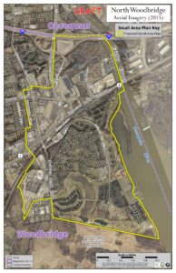
Small Area Plan: North Woodbridge
Parkway Employment Center
An update of the existing Parkway Employment Center sector plan at I-95/Horner Road/Prince William Parkway. A .pdf of the 2008 sector plan is available here.
Route 29
There is not a lot of information available for this plan yet. It will include a bike path along US-29 between US-15 and Somerset Crossing.
Future SAP projects include Independent Hill, Triangle, Yorkshire, and Fairgrounds/New Dominion.
Ryan Foster ([email protected]), Community Development Manager, and David McGettigan ([email protected]), Long-Range Planning Manager, are the primary points of contact for questions or comments.
Active Prince William is a group of concerned citizens who advocate for improving opportunities, support, and infrastructure for active transportation and healthy lifestyles within Prince William County, Manassas, and Manassas Park. We are interested in helping to make Prince William County and Greater Manassas a more livable and sustainable Community.