Advancing active mobility in greater Prince William, Virginia

Category: Bike Trails (Page 1 of 5)

The Rte 234/Brentsville Rd Interchange Needs Better Bike & Ped Access to and from Bus. Rte 234/Dumfries Rd

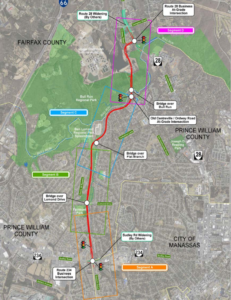
Routing for bicyclists and pedestrians in the approved Route 234/Brentsville Road Interchange Project design

In early February 2024, Active Prince William asked the Prince William County Department of Transportation to improve pedestrian and bicycle access and safety between the Business Route 234/Dumfries Road corridor in the vicinity of Godwin Drive and the Route 234/Brentsville Road Interchange project, which is nearing the end of its construction.  County staff replied that they will look into our request but did not commit to any action.  Our written request is copied below.


Potomac Local’s recent update on the Route 234/Brentsville Road Interchange project reported that this $55 million project is currently $2 million under budget.

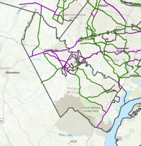
We are inquiring about the County’s plans for safe and convenient pedestrian and bicycle access along the Business Route 234/Dumfries Road corridor between the new interchange and the City of Manassas.  From previous correspondence, Mr. Belita indicated a ten-foot wide shared use path will be built along the west side of Business Route 234/Dumfries Road between the Bradley Cemetery Way area and Godwin Drive.

We firmly believe that 10-foot wide shared use paths are needed along both sides of Business Route 234 to provide reasonable and much-needed pedestrian and bicycle access to and from this Interchange.

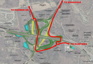
Along the west side of Business Route 234, the shared-use path between at least Godwin Drive and the Bradley Cemetery Way area will provide safe foot and bicycle access to and from Godwin Drive heading west (including to the adjacent Mayfield Trace community) and could also connect to a future northwestern extension of the regionally significant shared-use path along the Prince William Parkway leading from the Brentsville Road Interchange.  In addition, the nearest shared-use path within the City of Manassas is along the west side of Business Route 234, between Hastings Drive and Donner Drive.

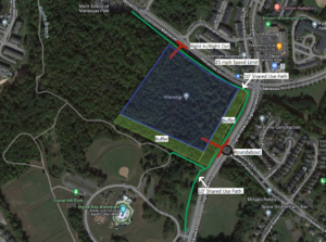
Along the east side of Business Route 234, a shared-use path from the Bradley Cemetery Way area would provide optimal access to the shared-use paths being built within this Interchange project that a) head south to cross over Route 234 to reach both Brentsville Rd heading south and the existing regional path along southbound Route 234 and that b) meander east through the Interchange to reach Liberia Avenue Extended/Route 294 toward Manassas.

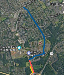
A shared-use path along the east side of Business Route 234 would optimally connect to the existing Bradley Square townhome development and the proposed Bradley South (REZ2003-00027) development.  From Bradley Manor Place, the existing Bradley Square subdivision streets readily lead to South Grant Avenue in the City of Manassas, a pleasant, existing low-traffic route for bicycling and walking that connects to Wellington Road (and from there to downtown Manassas via multiple routes).

We are disappointed that the current Bradley South rezoning proposal is rather inhospitable for bicycling and walking.  Business Route 234/Dumfries Road would have a 50 MPH design speed and a 45 MPH posted speed limit, and the developer of Bradley South would only be required to proffer a sidewalk along the east side of Dumfries Rd.  By contrast, the connecting segment of Dumfries Road at the south end of the City of Manassas has only a 35 MPH posted speed limit (which is better but also too high in our opinion).

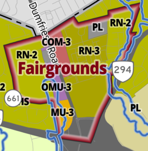
Furthermore, with continued residential, commercial, and mixed-use development along the Business Route 234/Dumfries Road corridor (including the Prince William County Fairgrounds), just south of the Manassas City Limits, the density of development will be comparable to that planned along Centreville Road (Route 28) in Yorkshire.

We ask that the budget surplus from this project and proffers from the Bradley South rezoning be used to provide a 10-foot wide shared-use path along the east side of that roadway (Dumfries Rd), from the Bradley Cemetery Way area to at least Bradley Manor Place.

Beyond that, to the extent feasible, the Interchange Project budget should also provide much-needed pedestrian infrastructure for crossing Business Route 234/Dumfries Road at Godwin Drive, including high-visibility crosswalks, at least one raised pedestrian crossing refuge within the roadway median, and either a pedestrian-activated crossing beacon (e.g., HAWK signal) or a conventional traffic signal with full pedestrian crossing components for at least two of the existing intersection legs.

Please let us know how the Route 234/Brentsville Road Interchange Project will suitably accommodate active mobility to and from the already well populated Business Route 234/Dumfries Road corridor.

Without safe and convenient foot and bike connections to the new Interchange from Business Route 234, the new Interchange will degrade active mobility to and from that populated corridor, and the new active transportation infrastructure within the interchange will be very underutilized.  Waiting five or more years for possible future rezonings along Business Route 234/Dumfries Road is not acceptable to complete these critical sections.

If the surplus funds from the Interchange project cannot be tapped to build either another shared-use path or a signalized pedestrian crossing of Business Route 234/Dumfries Road at Godwin Drive, we believe that low-cost or no-cost alternative interim improvements could readily be implemented along the east side of Business Route 234/Dumfries Road that would still substantially improve pedestrian and bicycle access and safety between the Bradley Cemetery Way area and Bradley Manor Place.

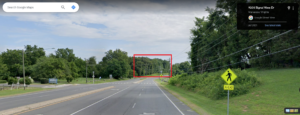
Google Street View shows that–before the Interchange was constructed–the paved width of Business Route 234/Dumfries Road was already about four or five lanes wide (i..e., 48 to 60 feet of asphalt pavement) for most of the distance between Bradley Cemetery Way and Bradley Manor Place.  There appears to be only a short stretch between Godwin Drive and the south end of Bradley Square where the pavement narrows to about 36 feet, but only two lanes are presently needed for vehicular travel along that segment.

Thus, the restriping of that roadway segment (with or without any asphalt resurfacing) should allow for at least a continuous 10-foot or wider northbound paved shoulder area leading up to the long right-turn-only lane approaching Bradley Manor Place.  That shoulder area could be protected from roadway traffic with some sort of hard physical barrier to serve as an interim shared-use path along the east side of Business Route 234/Dumfries Road between the Bradley Cemetery Way area and Bradley Manor Place.

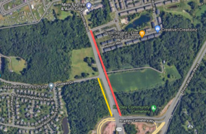
This recent photo (below) of northbound Route 234 Business/Dumfries Road near Bradley Cemetery Way shows that a wide paved shoulder is already present at that location.  While less wide than optimal, that existing paved shoulder could serve as an interim two-way shared-use path if it’s protected from the roadway traffic with a suitable hard barrier.

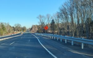
Northbound Business Route 234/Dumfries Road just north of the Interchange on February5, 2024

In addition, a striped conventional bike lane in each direction may also be feasible.  In the southbound direction, a striped on-road bike lane would be especially useful, from the Manassas City Line to Godwin Drive, for the dozens of bicyclists who participate in Bull Run Bicycles Tuesday Evening Shop Ride, almost every Tuesday evening during daylight saving time.  South of Godwin Drive, a southbound bike lane should not be needed because a new shared-use path will be located along that segment.

Finally, we again request that whatever pedestrian and bicycling improvements cannot be accomplished under the current Interchange project become required proffers as part of the Bradley South rezoning.

Our Comments for the National Capital Trail Network Update in Greater Prince William

October 2023 draft update of the National Capital Trail Network in greater Prince William.  The green lines are supposed to depict existing trail segments, whereas the purple lines are supposed to depict “planned” trail segments.

The National Capital Trail Network (NCTN) is a 1,400-mile, continuous network of long-distance, off-street trails, serving the entire [metropolitan Washington] region and consisting of both existing and planned segments.  The network was approved by the National Capital Region Transportation Planning Board (TPB) in July 2020 and endorsed by the Metropolitan Washington Council of Governments Board of Directors in August 2020.

As described by TPB staff:  The National Capital Trail Network is intended to be a network of long-distance, off-street facilities. It will be accessible for people of all ages and abilities, designed for non-motorized use, and suitable for both transportation and recreation.  Off-street path width minimums are 10 feet for new construction, 8 feet for existing paths. Paths must be paved or firm surface. On-street facilities must be protected from moving traffic (i.e. parked cars, curbs, or flexposts). All facilities must be directly connected to the network. Short on-street connections on low-volume, low speed streets are permitted to maintain network continuity. Facilities can be existing or planned, but they must be in an approved agency plan.

In June 2022, the TPB adopted a resolution (R18-2022) that called for completing the TPB’s National Capital Trail Network by 2030, as one of seven priority strategies for reducing greenhouse gas emissions from surface transportation in the Washington region.

For at least several months, the TPB staff have sought to engage the region’s localities to submit updates and corrections to the NCTN mapThe main purpose of this update is to measure progress, in miles built, toward the completion of the National Capital Trail Network since its adoption in 2020. Other purposes include adjusting routes where the existing route has proven infeasible or undesirable, addition of new routes where a new plan or new development justifies it, and correction of errors or omissions in the network [emphasis added].

To facilitate this update, Active Prince William submitted the comments below on October 30, 2023.


Comments on the Draft Update to the National Capital Trail Network Map for Prince William County and the City of Manassas
by Allen Muchnick, Co-Chair Active Prince William

1) Nonexistent/”Planned” Trail Segments Erroneously Labeled As “Existing”:  The following segments on the NCTN map should be relabeled as “planned” because they do not currently exist.

  • Nokesville Rd/Rte 28 between the Fauquier County Line and Fitzwater Dr in Nokesville. The segment of Rte 28 west of Fitzwater Dr in Nokesville has not been widened.  It’s still a two-lane road without any bicycle or pedestrian facilities.
  • Minnieville Rd, between Old Bridge Rd and Dumfries Rd, is depicted as having an existing shared use path along it except for the segment (TIP_ID BP11611) between Fowke Ln and Cardinal Drive. However, the NCTN update map erroneously shows this planned segment with a southwest terminus at Smoketown Rd, rather than at Cardinal Dr.  The segment of Minnieville Rd that currently lacks any bicycle facilities is much longer than shown on the NCTN update map.

2) NCTN Segments Currently Labeled As Planned That Have Recently Been Completed:  The following NCTN segments should now be relabeled as “existing”.

  • Nokesville Rd/Rte 28 Shared-Use Path, between Godwin Dr and the PWC Line, in the City of Manassas (TIP_ID 11606).
  • Godwin Dr Shared-Use Path (south), between Wellington Rd and the Winters Branch Trail, in the City of Manassas (TIP_ID BP11604). Note: TIP_ID BP7624 appears to be a duplicate path, possibly on the PWC side of Godwin Dr, which is probably not actually planned and, if so, should be deleted from the map.
  • US-1 Shared-Use Path in North Woodbridge (southern segment of TIP_ID BP7634): The segment between Annapolis Way and Gordon Blvd is complete.
  • Blackburn Rd Shared-Use Path near Neabsco Creek (the bulk of TIP_ID BP7641): The segment between Rippon Blvd and Good Shepherd Lutheran Church is complete.
  • Wellington Rd Shared-Use Path (the western end of TIP_ID 7632): The segment between Linton Hall Rd and University Blvd near Gainesville/Virginia Gateway is complete.
  • VA 234/Dumfries Rd Shared-Use Path (TIP_ID BP7639): This former gap segment between Country Club Dr and Exeter Dr near Montclair is complete.

3) Planned NCTN Segments Depicted On An Erroneous Alignment:

4) Planned NCTN Segments That Should Be Updated: 

  • Manassas Dr east of Signal View Dr in Manassas Park (TIP-ID BP7643): The new Manassas Park Active Transportation Plan identifies an even larger segment of eastern Manassas Dr (between Railroad Dr and Blooms Park) as a candidate for bicycle lanes implemented with a road diet (Project B-10). The NCTN map currently labels the segment of Manassas Dr east of Signal View Dr as planned for a shared-use path.

5) Nationally Significant Long-Distance Trails That Should Be Added to the NCTN Map As “Planned NCTN Segments”:

  • US Bicycle Route 1: At present, a considerable portion of US Bicycle Route 1 through Prince William County is quite hostile to bicycling, even by experienced cyclists.  However, the segments of this route along Fleetwood Dr (Fauquier County Line to Aden Rd), Aden Rd (Fleetwood Dr to Bristow Rd), Bristow Rd (Aden Rd to Independent Hill Dr), Independent Hill Rd (Bristow Rd to Route 234), all of Hoadly Rd, Minnieville Rd (the segment missing a shared-use path from Prince William Pkwy to Fowke Ln), and Old Bridge Rd (Minnieville Rd to Tanyard Hill Rd) are all identified for future shared-use paths in Prince William County’s December 2022 Comprehensive Plan and therefore should be depicted as Planned NCTN segments on the updated NCTN map.
  • East Coast Greenway and Potomac Heritage National Scenic Trail: Except to depict existing or planned sidepaths along Route 1, the current NCTN map does not depict most of the planned ultimate route(s) for the East Coast Greenway and the paved, shared-use segments of the Potomac Heritage National Scenic Trail through Prince William County.  The updated NCTN map should depict those planned routes.

###

Our Comments on the Mayfield Crossing Rezoning Application

Our key recommendations for the proposed Mayfield Crossing development are summarized above

On August 28, 2023, a rezoning application (Plan Number: REZ2024-00007; Mayfield Crossing) was submitted to Prince William County for a proposed new residential development at the intersection of Manassas Drive and Signal View Drive, just outside the City of Manassas Park.   The applicant seeks to rezone a forested 20.56-acre parcel adjacent to Signal Hill Park to develop a residential community with up to 288 dwelling units.  On September 5, Active Prince William submitted the following initial feedback on the proposed development:


We have reviewed the Mayfield Crossing Rezoning package [8/28/2023] (corner of Manassas Dr. and Signal View Dr.) posted through the PWC DAPS.  While we are disappointed to see this wooded lot adjacent to the Signal Hill Park be developed, we hope you consider the following comments and feedback as this project moves through the rezoning process.

Our concerns are regarding 1) bike/pedestrian infrastructure along Manassas Dr and Signal View Dr (connection to Signal Hill Park), 2) ingress/egress from the new development, and 3) the viewshed from Signal Hill Park/Signal View Dr.  Above is a diagram of our recommendations which are explained in detail below:

1. Bike/pedestrian infrastructure along Manassas Dr and Signal View Dr (connection to Signal Hill Park)

Below is a diagram of the current language for Pedestrian Circulation in the rezoning package.  The draft Manassas Park Active Transportation Plan calls for a shared-use path along Manassas Dr and a sidewalk along Signal View Dr next to the development.

The applicant’s proposed Pedestrian Circulation Plan

We recommend the applicant construct:

  • A shared-use path along Manassas Dr, from Digital Dr to Signal View Dr.
  • A shared-use path along Signal View Dr, from Manassas Dr to the Signal Hill Park Entrance.

Justification: These recommendations complete the trail segments adjacent to the development and the necessary connections to provide a safe connected bike/ped network to nearby destinations.  A shared-use path along Signal View Dr is more aesthetically pleasing and matches the existing infrastructure along the roadway.  In addition, it reduces the need to cross Signal View Drive in front of Signal Hill Park, which can be a hazard for people walking and bicycling.

2. Ingress/egress from the new development

The current language for ingress/egress in the rezoning package is below:

The site layout has approximately 950 feet of frontage along Manassas Drive to the north and 800 feet of frontage along Signal Hill Drive. Access to the site is proposed at a full movement entrance along Manassas Drive opposite Christopher Lane and a full movement entrance along Signal View Drive opposite Roseberry Farm Drive.

The package also indicates right-turn deceleration lanes on Manassas Dr and Signal View Dr. to access the new development

We recommend the applicant construct:

  • Right-In/Right-Out access to/egress from the new development on Manassas Dr with no deceleration lane.  We also recommended that the City of Manassas Park lower the speed limit on Manassas Dr, from Signal View Dr to Railroad Dr, to 25mph.
  • A Single-Lane Roundabout on Signal View Dr at the intersection of Roseberry Farm Dr and the ingress/egress point of the new development.

Justification:  As this area continues to urbanize, we must design our transportation network for all users and not on the elements that enable the fast movement of motorized vehicles.  A 25-mph speed limit would eliminate the need for a deceleration lane on Manassas Dr, whereas the full-movement unsignalized intersection on Manassas Dr proposed by the applicant would create more conflict points that lead to an increase in vehicle crashes.

A roundabout on Signal View Dr would provide much safer ingress/egress for residents of Roseberry Farms as well as residents of the new development.  It would also reduce the speed of vehicles on Signal View Dr and enable an opportunity to create gateway signage to enter Signal Hill Park (Signal Hill Park is on both sides of Signal View Dr.)

3. Viewshed from Signal Hill Park/Signal View Dr

The current illustrations in the rezoning package show limited or no tree buffer along Signal View Dr and along the south side of the development adjacent to Signal Hill Park.

We recommend that the applicant:

  • Maintain a 50’-100’ tree buffer along Signal View Dr (similar to Roseberry Farms)
  • Maintain a 50’-100’ tree buffer along the south side of the development adjacent to Signal Hill Park
  • Bury all utilities along Manassas Dr, from Digital Dr to Signal View Dr
  • Bury all utilities along Signal View Dr adjacent to development (prefer if all utilities could be buried in Signal Hill Park)

Justification:  The viewshed from the Civil War Monument/Entrance to Signal Hill Park along Signal View Dr should be maintained.  See picture below.

The current view from Signal View Drive (from Google Maps Street View)

Thank you for considering these recommendations as the Mayfield Crossing Rezoning project moves through the rezoning process.

###

Our May 2023 Comments on the Route 28 Bypass Project

On April 19 and 20, 2023, the Prince William County Department of Transportation held a pair of public information meetings to present the status of its Route 28 Bypass project at roughly the 30% design stage.  In response to the information presented, Active Prince William submitted the following written comments on May 3, 2023.

Related Update:  On May 23, 2023, the Prince William County Trails and Blueways Council unanimously adopted this resolution that also calls for better shared-use path connections in the Route 28 Bypass project.


Please consider these comments on the Route 28 Bypass, based on information that was presented at the April 19 and 20 Route 28 Bypass Project Public Information Meetings:

Traffic and Environmental Studies, Sustainability, and Cost Comments

The ongoing traffic forecast and environmental studies for the Bypass should report relevant data that will help the public, the Prince William Board of County Supervisors, environmental oversight agencies, and other stakeholders determine whether building this highway project would be a prudent investment for both our region and for Prince William County taxpayers.

 1.  Please report the additional Vehicle Miles Traveled (VMT) and Greenhouse Gas (GHG) emissions this project would generate vs. the no-build alternative.

Justification:  The information will help the PWC BOCS make an informed decision about the project as it weighs competing priorities about the environment and sustainability, including consistency with Visualize 2050’s policies and the objectives of the County’s own Community Energy and Sustainability Master Plan.

2.  Please report the additional noise and air pollution this project would generate within ½ mile of the corridor vs. the no-build alternative.

Justification:  Understanding the full impacts on nearby property owners within an Equity Emphasis Area that would lack direct access to the roadway facility is paramount for PWC BOCS to make strategic future decisions about this project vs. other priorities.

3.  Please report the residency locations of the projected Route 28 Bypass users; in particular, what percentage of projected highway users would reside in a) Prince William County, b) the City of Manassas, c) localities west or south of Prince William County, and d) localities north or east of Prince William County?

Justification:  With 90%+ of the cost of the project being funded by PWC taxpayers via NVTA and the 2019 Mobility Bond, this is useful information to help the PWC BOCS make strategic future decisions about this project vs. other priorities.

4.  Please report an updated project cost estimate based on the 30% design.

Justification:  With highway construction costs increasing by 50% in the past two years, it is difficult for stakeholders to understand the viability of a 2019 $300M cost estimate as the PWC BOCS plans to invest significant taxpayer $$$ into the project soon.

* * *

Shared Use Path/Trail Comments

If located in most other suburban communities, the Flat Branch stream valley would have been developed–decades ago–as a linear regional park, with non-motorized access serving and unifying the communities on either side.  Because the County has long reserved this corridor for a potential future freeway, the development of such a stream valley park has been delayed for decades.  Construction of the Bypass would establish a permanent man-made physical highway barrier between the equity-emphasis-area communities on each side.  In the interests of environmental justice and sustainable transportation, it is essential that the Bypass include a robust network of paved (and natural-surface) trails for transportation and recreation, both along and across the stream valley.

* * *

5.  Please consider relocating the adjoining shared-use path–along the Bypass segment between Sudley Rd and the Bypass bridge over Flat Branch–to follow the west side of the Bypass, to facilitate access from the Fairmont, West Gate, and Sudley communities.

In addition, build local asphalt shared-path connections between the relocated shared-use path along the west side of the Bypass to the Fairmont, West Gate, and Sudley neighborhoods from at least these five locations:

Also, please ensure that all shared-use paths are generally designed to be as flat/level as the Bypass roadway, except where needed to achieve grade-separated roadway or stream crossings.  Provide physical barriers between the shared-use path and the roadway–such as non-mountable concrete curbs and/or jersey barriers–especially wherever the grass buffer between the shared-use path and the roadway would be less than eight feet wide

Justifications:  The Flat Branch stream would limit and complicate access to any shared-use path along the east side of the Bypass from the neighborhoods in Loch Lomond; any shared-use  along the Bypass requires frequently spaced connections to nearby neighborhoods for reasonable access by foot or bicycle; and any shared-use path near the Bypass must provide a physical barrier from roadway departures by high-speed motor vehicles.

 *  *  *

6.  Please consider developing and improving the existing UOSA access road to the east of the Bypass as a second, better separated shared-use path , with trail bridge connections across Flat Branch and its tributaries to serve the Loch Lomond neighborhood between Sudley Rd and Splashdown Waterpark.  This shared-use path should be extended beyond the current northern end of the UOSA access road, to parallel the remainder of the Bypass to its northern terminus along its east side.  Trails along UOSA easements are common in Fairfax County.

In addition, provide access to the UOSA access road/future shared-use path along the east side of the Bypass from the Loch Lomond neighborhood via asphalt shared-use paths (with ped/bike trail bridges across Flat Branch and/or its tributaries where necessary) from at least these eight locations:

Use trail underpasses in stream box culverts, the Bypass bridge over Flat Branch, or along both sides of Lomond Dr to connect the shared-use path along the current UOSA access road to the relocated shared-use path along the west side of the Bypass and from there to the Fairmont, West Gate, and Sudley communities.

Justification:  The area along Flat Branch should be developed into a linear park for enjoyment by the surrounding communities that would lack direct access to the new roadway.  By providing shared-use paths along both sides of the Bypass, the shared-use path connections under the Bypass would become much more effective in linking the low- and moderate-income, majority-minority communities that the Bypass would otherwise permanently sever

* * *

7.  Please design a shared-use path /trail connection under the Bypass bridge that crosses over Flat Branch.

Justification:  This connection would provide non-motorized access between communities on the east and west of the Bypass and provide communities on the east side of the Bypass with access to Splashdown Waterpark, thus reducing vehicle trips along neighborhood streets.  Moreover, north of the Bypass bridge over Flat Branch, only one shared-use path would be provided along the Bypass, on its east side, and the UOSA access road ends south of that crossing .  In other words, this trail connection would extend any adjacent shared-use path that begins on the west side of the Bypass at Sudley Rd though the remainder of the Bypass route.

* * *

8.  Please consider leaving all or part of the existing Old Centreville Rd Bridge over Bull Run in place as the Ped/Bike connection over the waterway.

Justification:  This reduces the cost to the project and is a much more pleasant access point and amenity to the surrounding community than walking or biking next to a 45-mph roadway

* * *

9.  Please consider including as part of the project planting hundreds/thousands of canopy trees to absorb and filter stormwater, reduce highway noise in the adjoining neighborhoods, and provide much-needed shade for trail users in warm and hot weather.  The trail(s) should also include user amenities such as trail lighting, benches, and trash receptacles.

Justification:  This project clearly bisects Equity Emphasis Areas while simultaneously not providing them access to the roadway.  It is imperative to add trail, park, and flood control amenities with the project to support the surrounding community.

* * *

Roadway Comments

10.  Please consider implementing a Continuous Green-T intersection at Route 28 Bypass/Old Centreville intersection.

Justification:  This allows for a non-stop southbound trip between existing Route 28 and Sudley Rd.

11.  Please consider providing some form of [emergency or uncontrolled] left turn capacity from Northbound Route 28 Bypass to Ordway Rd.

Justification:  During  incidents  in or around the Route 28/Compton Rd intersection, this capacity would provide a relief valve to clear traffic congestion more quickly

12.  Please consider adding a left turn from Route 28 Northbound to Route 28 Bypass Southbound (with access to Ordway Rd) and removing both left turns from Route 28 Compton Rd intersection.

Justification:  This creates a third light phase to the Route 28 Bypass/Route 28 intersection and reduces the Compton Rd/Route 28 intersection to three light phases.  Access via Ordway Rd provides the route to Compton Rd.  This will improve synchronization between the two adjacent light signals (Route 28/Route 28 Bypass & Route 28/Compton Rd).

* * *

Thank you for soliciting public comments at this early stage of project design.  We would be happy to meet with members of the project team to discuss these comments in more detail.

Sincerely,

Mark and Allen

Mark Scheufler & Allen Muchnick, Co-Chairs
Active Prince William
Advancing active mobility for a more livable, equitable, & sustainable greater Prince William, Virginia
Email: [email protected]
Website: www.activepw.org
Facebook: https://www.facebook.com/ActivePW
Twitter: @Active_PW https://twitter.com/Active_PW

###

NoVA Trails Summit, October 20, 2022

The Northern Virginia Regional Commission (NVRC) will host a Northern Virginia Recreational Trails Summit on Thursday, October 20, 2022 from 10 am to 2:30 pm at its offices at 3040 Williams Drive, Suite 200, Fairfax VA 22031.

This will be a working meeting to identify opportunities to create connections and improve communities through recreational trails in Northern Virginia.

The Northern Virginia Regional Commission and partner organizations invite all interested jurisdictions and organizations to partner and share thoughts and ideas on how to improve our communities through the coordination and development of trails and parks.

Interested representatives and staff, community organizations, and businesses can register a member or representative.   NVRC and our partners look forward to a diverse and engaging group of attendees and would love to see new faces and hear new voices!  Space is limited, so please register early!

To learn more about NVRC and its role in the Potomac Heritage National Scenic Trail visit https://www.novaregion.org/299/Potomac-Heritage-National-Scenic-Trail.

« Older posts