Advancing active mobility in greater Prince William, Virginia

Category: Transit (Page 1 of 4)

Our Comments on PWC’s Proposed Transit Alternatives Map

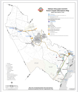
Prince William County’s Proposed “Future Transit Alternatives Map” Dated March 17, 2022

On April 15, 2022, Active Prince William submitted the following public comments on the draft “Future Transit Alternatives Map” that defines the public transportation element for the update to Prince William County’s Comprehensive Plan known as “Pathways to 2040”.


1) The Future Transit Alternatives Map needs to identify specific sites for proposed High-Capacity Transit stations that would exist by the year 2040.

The Metropolitan Washington Council of Governments needs to accept those sites on its map of High Capacity Transit Station Areas and to agree that they qualify as “Regional Activity Centers” (using the MWCOG definition of that term), so Prince William’s 2040 Comprehensive Plan is consistent with the Metropolitan Washington Planning Framework for 2030.

Unless specific station sites are identified, the Mobility Chapter will not be integrated with the Land Use and Housing Chapters.  Identifying the planned locations of future VRE and Metrorail stations is required for the Land Use Chapter (including Land Use Map) to specify where new Transit-Oriented Development (TOD) will be planned within walking distance of High-Capacity Transit Stations.  Identifying the planned locations of future VRE and Metrorail stations is required for the Housing Chapter to plan to meet regional housing targets set with MWCOG.
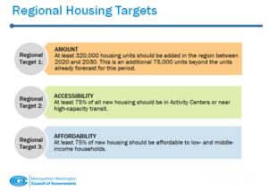
MWCOG’s Regional Housing Targets

2) The Future Transit Alternatives Map should clarify if all projects shown on the map are planned to be completed by 2040.   If some projects will have a longer time frame, then the projects planned to be completed by 2040 should be identified clearly or included on a separate map.  In particular, the proposed extensions of the Metrorail Orange Line and the VRE Manassas Line are redundant, and both are likely unnecessary with the advent of the I-66 Express Lanes.  The Future Transit Alternatives Map should clearly identify that the existing I-95 and imminent I-66 Express Lanes are “existing” High-Capacity Transitways.

Knowing what projects are expected to be built over the next 20 years is necessary so other Comprehensive Plan policies, action strategies, and projects can be budgeted and synchronized.  Maps showing planned roads and trails should also identify projects planned for completion by 2040, plus other aspirational projects using the same approach for transit projects.

3) The Mobility Chapter should include action strategies to acquire right-of-way for the proposed route of the Orange Line to Gainesville or that project should be removed from the map.  Unless located within the I-66 right of way, the right-of-way for the Orange Line extension may require going through Bull Run Regional Park, Manassas National Battlefield Park, and/or high-value commercial properties.  Fairfax County committed almost $60 million to preserve right-of-way along the I-66 corridor for extending Orange Line to Centerville during expansion to create Express Mobility Partners toll lanes, but Prince William preserved no right-of-way–suggesting a proposal for extending the Orange Line to Gainesville is more of a fantasy than an actual plan.

4) If the proposed route of the Orange Line to Gainesville remains on Future Transit Alternatives Map , then the Land Use Chapter should include plans for town centers with T-5 and T-6 Transect Zones at the station locations.

5) The Mobility Chapter should define the southern terminus of the proposed Blue/Yellow Line in eastern Prince William, and that terminus should subsequently be identified in the Visualize 2045, TransAction, and VTrans plans.

6) The Mobility Chapter should include action strategies to acquire right-of-way for the proposed route of the Blue/Yellow Line to Triangle or of the proposed BRT system.

7) The proposed route of the Blue/Yellow Line to Triangle , or of the proposed BRT system, should be clarified so it will be clear what land parcels will be suitable for Transit-Oriented Development.  In particular, it should be clear if the large Potomac Mills site will have a High-Capacity Transit station at one edge, because portions of that property could end up more than one-half mile from a station.

8) The Quartz development at the intersection of Minnieville Road and Prince William Parkway, and the intersection of Dale Boulevard-Minnieville Road should not be designated as “MultiMobile Hubs” if those sites will not have a High-Capacity Transit station.  Bus stops with commuter lots technically might be “multimobile,” but should not be planned for the same level of development as sites with a High-Capacity Transit station.
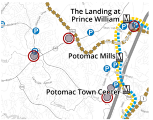
Proposed “Future Transit Alternatives” for Eastern Prince William County

9) Plans for town centers with T-5 and T-6 Transect Zones should be included in the Land Use Map for all sites in eastern Prince William where a High-Capacity Transit station is planned.

10) Action strategies in the Mobility Chapter should identify how to obtain local, state, and Federal funding for extension of Metrorail to Prince William, creation of a Bus Rapid Transit system and shuttle/trolley systems, and development of infrastructure for the proposed commuter ferry.

11) The Land Use Map should identify where affordable housing is planned within walking distance of planned High-Capacity Transit stations, in order to meet the MWCOG targets.  Families are cost-burdened if housing costs exceed 30% of Area Median Income, but also cost-burdened if housing and transportation costs combined exceed 42% of Area Median Income.

12) The 2040 Comprehensive Plan should quantify the shortage of affordable housing units for families earning 30%, 50%, and 80% of Area Median Income now, and the projected shortage in 2030 and 2040.  The Land Use Map should identify where new affordable housing will be developed by 2030 and 2040 to eliminate the shortage of affordable housing in those three categories, and those locations for new affordable housing should be planned within walking distance of High-Capacity Transit stations.

13) More-detailed shuttle/trolley routes and boundaries of areas where service is planned should be identified on the Future Transit Alternatives Map.  The Mobility Chapter should include an action strategy to complete and update regularly origin and destination studies for proposed shuttle/trolley routes, in order to integrate the Mobility Chapter with other 2040 Comprehensive Plan chapters and with the Comprehensive Plans in the Cities of Manassas and Manassas Park. Shuttle/trolley routes should be structured to connect Activity Centers as defined by MWCOG and also nodes of existing/planned dense development as shown on the Land Use Map.

14) An action strategy should be included in the Mobility Chapter to identify the year when shuttle/trolley service will become operational, so rezonings and construction plans can be synchronized.

15) If “[s]pecific objectives include adapting to changing mobility trends, improving multi-modal options, increasing the use of public transit, increasing travel time reliability while concurrently striving to decrease the use of vehicle fuels that contribute to climate change,” then the Mobility Chapter needs to add Local and Express Bus Service maps showing areas to be served by bus service and the stages in which that service will be expanded over the next 20 years.  Upgrading local bus service to facilitate access to local jobs, schools, healthcare, retail, and other key destinations for less-advantaged households is at least as essential as extending commuter rail routes that carry white-collar workers out of Prince William. Upgrading low-cost local transit and upgrading bike/pedestrian access offers the greatest opportunity to invest in upgrading equity.  Fairfax Connector Transit Strategic Plan Update offers an understandable format that can be used to support comprehensive plan update effort

16) “High-Capacity Transit”, as identified on this map, should be adequately defined in terms of weekday boardings, peak-period headways, and service hours.  Bus service that operates for fewer than 16 hours on weekdays, has peak-period headways longer than 15 or 20 minutes, or experiences fewer than 500 daily boardings is merely ordinary transit service.

17) The “High-Capacity Transit” lines in the western part of the county, which lack connections to Downtown Manassas, the Manassas Park City Center, the Godwin Drive Technology Corridor, and Sudley Road/Route 234 Business, are missed opportunities.  Recommend coordinating with Omniride which represents the entire Greater Manassas area.

###
Annual Northern Virginia Joint Transportation Meeting, Wednesday, December 15, 2021 at 7:00 PM

The Virginia Department of Transportation issued the following news release on November 22, 2021:

RELEASE:

CONTACT:

IMMEDIATE

Kathleen Leonard, VDOT | 703-638-9115
Haley Glynn, DRPT | 804-351-6647
Karen Finucan Clarkson, VRE | 571-255-0931
Erica Hawksworth, NVTA | 571-355-4661
Mathew Friedman, NVTC | 571-457-9516

NOVA-184807

Nov. 22, 2021

Learn about Agency Projects, Programs at Northern Virginia Joint Transportation Meeting Dec. 15

Join the Commonwealth of Virginia, Northern Virginia Transportation Authority, Northern Virginia Transportation Commission and Virginia Railway Express for a virtual public meeting

FAIRFAX–The public is invited to a joint virtual meeting on Wednesday, Dec. 15, 2021 with representatives from the Commonwealth Transportation Board, Virginia Department of Transportation, Virginia Department of Rail and Public Transportation, Office of Intermodal Planning and Investment, Northern Virginia Transportation Authority, Northern Virginia Transportation Commission and Virginia Railway Express, to learn more about the regional collaboration required to keep travelers in Northern Virginia moving.

Per Virginia code §33.2-214.3, these organizations shall conduct a joint public meeting annually for the purposes of presenting to the public, and receiving comments on, transportation projects proposed and conducted by each entity in Planning District 8 (Northern Virginia).

The meeting will include an opportunity to receive public comments following agency presentations on transportation initiatives, including:

  • VDOT’s Multimodal Project Pipeline Program
  • NVTA’s updates to TransAction and the FY2022-2027 Six Year Program; the NVTA Transportation Technology Strategic Plan; and the Regional Multi-Modal Mobility Program (RM3P) in partnership with the Commonwealth of Virginia
  • NVTC’s Commuter Choice program
  • DRPT’s funding opportunities, Six Year Improvement Program and the Virginia Passenger Rail Authority (VPRA)
  • VRE station, and storage- and maintenance-facility projects

The meeting will be held as a virtual/online and attendees must register online. The team of VDOT, DRPT, OIPI, NVTA, NVTC and VRE representatives will make a presentation beginning at 7 p.m. highlighting their transportation programs, regional collaboration and receive public comments about Virginia’s transportation network.

Comments may also be submitted through January 7, 2022 via this online comment form, by voicemail to 703-721-8270, by email to [email protected] (please reference “Northern Virginia Joint Transportation Meeting” in the subject line) or by mail to Ms. Maria Sinner, VDOT, 4975 Alliance Drive, Fairfax, VA 22030.

Meeting materials and presentations will be posted on this page.

About the Agencies

The Commonwealth Transportation Board (CTB), the policy board for the Virginia Department of Transportation, Virginia Department of Rail and Public Transportation, and the Office of Intermodal Planning and Investment, allocates public funds to highway, road, bridge, rail, bicycle, pedestrian, public transportation, and transportation demand management projects. Virginia’s SMART SCALE scores projects on factors of safety, congestion reduction, accessibility, land use, environmental quality, and economic development.

The Virginia Department of Transportation (VDOT) and the Virginia Department of Rail and Public Transportation (DRPT) are state agencies reporting to the Secretary of Transportation, focused on the movement of people and goods throughout the Commonwealth. VDOT is responsible for building, maintaining and operating the state’s roads, bridges and tunnels. DRPT’s primary areas of activity are rail, public transportation, and commuter services, working with local, regional, state, and federal governments, as well as private entities to support for projects and programs.

The Northern Virginia Transportation Authority (Authority) is a regional body that is focused on delivering transportation solutions and value for Northern Virginia’s transportation dollars by bringing NoVA jurisdictions and agencies together to plan and program regional multimodal transportation projects focused on relieving congestion.

The Northern Virginia Transportation Commission (NVTC) advances a robust and reliable public transit network to support communities in Northern Virginia.

The Virginia Railway Express (VRE) has been providing commuter rail service between Central and Northern Virginia and the District of Columbia since 1992. As a participant in the commonwealth’s $3.9 billion Transforming Rail in Virginia program, VRE has many station-improvement and maintenance-and-storage facility projects at various levels of implementation.

ctb.virginia.gov | virginiadot.org | drpt.virginia.gov | thenovaauthority.org | www.novatransit.org | www.vre.org | oipi.virginia.gov

VDOT ensures nondiscrimination and equal employment in all programs and activities in accordance with Title VI and Title VII of the Civil Rights Act of 1964. If you need more information or special assistance for persons with disabilities or limited English proficiency, contact VDOT Civil Rights at 703-259-1775.

END

Our Comments on the Thoroughfare Plan Element of the Mobility Chapter in the PWC Comp Plan Update

On June 16, 2021, Active Prince William submitted the following general and specific comments on the Thoroughfare Plan Element of the Mobility Chapter in Prince William County’s Pathways to 2040 Comprehensive Plan


Comments on the Thoroughfare Plan Element of the Mobility Chapter in Prince William County’s Pathways to 2040 Comprehensive Plan

Active Prince William encourages Prince William County to refine its Thoroughfare Plan to support its climate and equity goals.  Please see the attached granular comments on each item in the Thoroughfare Plan that provide a more realistic plan to achieve by 2040.  Below are a few highlights.

  1. Dedicated bus lane infrastructure (Bus Only/BAT[Business Access and Transit]) should be planned for many major roadway arterials (ex. Route 1, Route 234 Business, Dale Blvd, Route 29)
  2. Roadway segments should be identified as “innovative intersection corridors” to replace previously planned lane-mile expansions (ex. Old Centreville Rd, Pageland Ln, Route 234, Prince William Parkway)
  3. Roadways through activity centers and commercial/mixed-use corridors should be redesignated as Urban Boulevards (UB) and Through Boulevards (UTB) (ex. Route 123 and Route 1 in North Woodbridge)
  4. Road diets should be considered for many roadway segments (ex. Occoquan Rd, Williamson Blvd, Lee Hwy/MNBP)
  5. Road capacity expansion should be configured as a managed lane (Toll, HOV, HOT, Bus, BAT). Adding any new unmanaged roadway capacity in the Washington region is unproductive at this point as it relates to future climate and congestion conditions and will only serve to induce SOV travel and increase VMT per capita.
  6. Major “managed lanes” roadway widenings should be packaged with dedicated bus infrastructure on nearby parallel roadways  (234 Bypass -> 234 Business, I-95 HOT ->Route 1)

Click here for our detailed comments on each roadway element in the Thoroughfare Plan.

The Route 28 Manassas Bypass Is Not the Lowest Cost Or the Least Environmentally Damaging Practicable Alternative (LEDPA) for the Route 28 Corridor

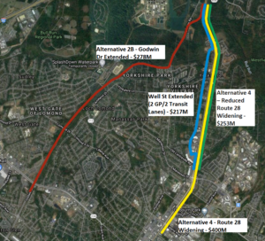
The Alignments of the Four Route 28 Corridor Expansion Alternatives Compared Below

Active Prince William board member Mark Scheufler sent the following comparison of Route 28 corridor alternatives to the Prince William Board of County Supervisors on November 30, 2020.


Dear Prince William Board of County Supervisors:

In advance of the December 7th  virtual public meeting on Route 28, it is timely to correct misinformation about the alternatives to Alignment 2B. The costs of Alternative 4 (Widening Route 28) were overstated by calculating the impacts/costs of widening Route 28 between Blooms Quarry Lane and Liberia Ave that is already six lanes.

Realistic cost estimates are needed not only by the supervisors in Prince William and Fairfax counties, but also by the US Army Corps of Engineers and the Virginia Department of Environmental Quality.  Those two agencies may determine that cost differences between Alignment 2B and other alternatives are not sufficient to justify the greater environmental damage.

As the Meeting Minutes at the January 16, 2020 Project Update and Alternatives Development Technical Memo Review  state (on pages 2 and 3):

“Stuart ended with a presentation of the cost summary for the alternatives, which showed that Alternative 4 would be almost $100 million more than Alternatives 2A and 2B. MacKenzie indicated that cost would not be a factor that the Department of Environmental Quality (DEQ) would consider in their evaluation. Rick responded that he understood, but emphasized the need to consider purpose and need in the comparison of the alternatives.

Subsequent to the meeting, Hannah Schul, DEQ, clarified that DEQ makes permitting decisions based on the Least Environmentally Damaging Practicable Alternative (LEDPA). Per the Clean Water Act, a permit cannot be issued if a practicable alternative exists that would have less adverse impacts on the aquatic ecosystem. The LEDPA does take cost into consideration, but an alternative would only be potentially eliminated if costs are clearly exorbitant compared to similar alternatives.”

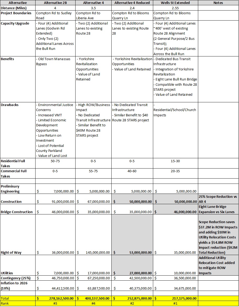
The analysis summarized in the table below [the complete ROW analysis is here] shows the cost of alternatives along or near existing Route 28 are not exorbitant compared to Alternative 2B.   Alternative 4 includes $37M in ROW impacts along a 1.1-mile section of Route 28 that is already six lanes and should require minimal improvement and no ROW impacts (Blooms Quarry Lane to Liberia Ave).  An additional $54M* in Alternative 4 ROW impacts could be mitigated by increasing the Utility Relocation Costs ($10M).  These modifications would bring the Alternative 4 cost estimate below Alternative 2B.  But implementing the Route 28 STARS recommendation and the Well St Extended recommendation  is the best alternative for the Route 28 corridor to meet transit, revitalization, and climate goals and is the cheapest alternative.  The Well St Extended recommendation was not included in the original set of alternatives because transit, revitalization and climate were not considered part of the project purpose and need.

A Comparison of Four Route 28 Corridor Alternatives (click on the image above to enlarge for reading)

Alternative 2B is not the Least Environmentally Damaging Practicable Alternative (LEDPA) and may not receive permits to move forward.  Creating a regional park along this alignment is the best use of the land in the flood plan.

*8300 CENTREVILLE RD, 8130 OAK ST, 7901 CENTREVILLE RD

If you need any clarification, please let me know.

Thanks,

Mark Scheufler

PWC Resident

Active Prince William Policy Positions for Active, Equitable, and Sustainable Mobility in Prince William County, Manassas, and Manassas Park (Revised 1/20/2020)

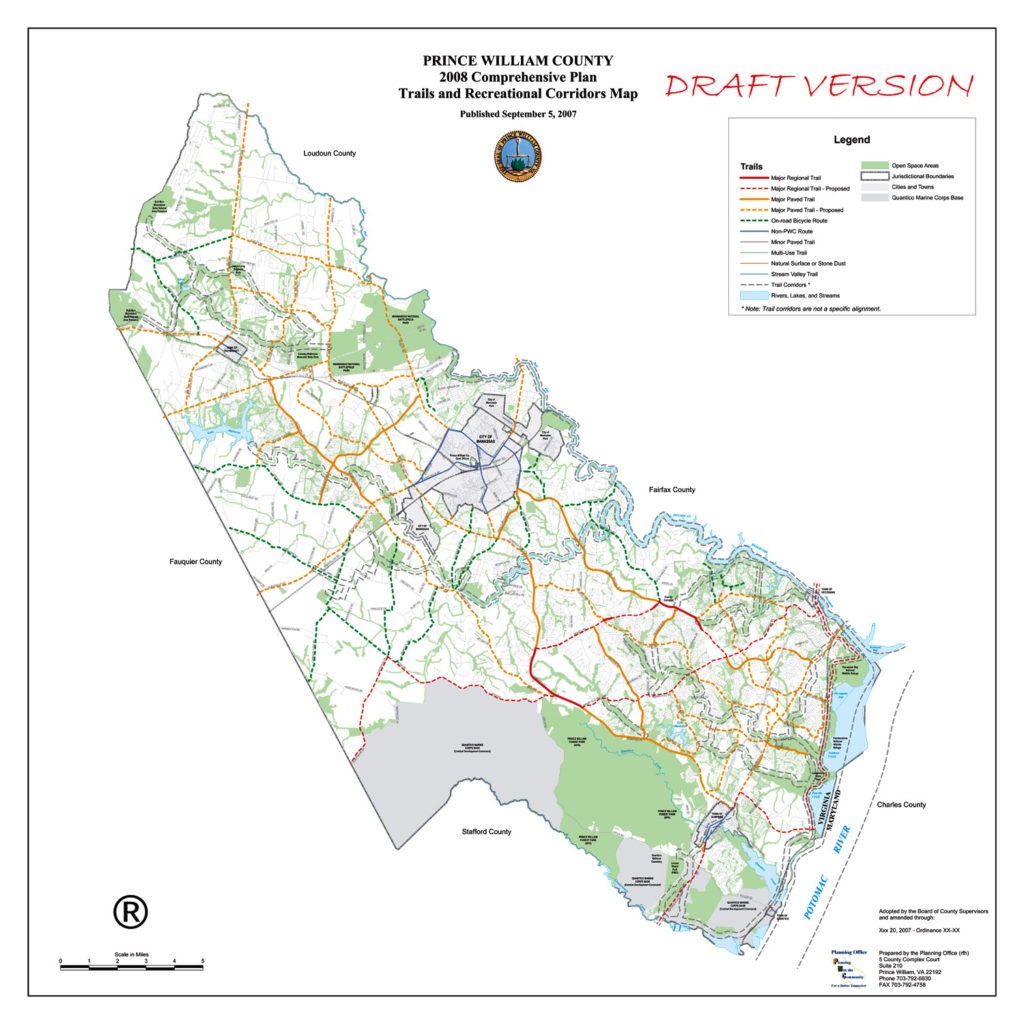
Proposed Prince William County Trails Network from 2007

1) Establish Citizen Transportation Advisory Commissions for Prince William County, Manassas, and Manassas Park.

2) Provide Meaningful and Robust Public Participation Processes for the Coming Comprehensive Plan Updates for the County and Cities.

3) Expand and Enhance Public Transportation as an Effective Travel Choice:

a) Add midday, evening, and reverse-commute VRE trips, possibly as shortened runs to/from Alexandria and/or Springfield/Franconia.

b) Add local and commuter bus service along Rte 28 and Sudley Rd, ideally in dedicated lanes.

c) Extend Richmond Hwy BRT south through Prince William County along the Rte 1 corridor to Quantico.

4) Build Complete Streets, especially a Primary Bikeway Network that Crosses Major Barriers (e.g., rivers, freeways, land parcels):

a) Build a continuous “I-66 Trail”, largely along Balls Ford Rd and across Bull Run into Fairfax County.

b) Build a quality bike/ped crossing of I-66 at or near Sudley Rd/Bus 234.  In short term, ensure space for paths beneath all new I-66 overpasses of Sudley Rd.

c) Retrofit quality bike/ped crossings of I-95, especially at/near Prince Wm Pkwy/Horner Rd and at/near Dale Blvd/Opitz Blvd, but also at/near Rte 123, 234, & Joplin Rd.

d) Complete a continuous trail along Rte 234, from Rte 1 to I-66, including the totally missing segment between Brentsville Rd and I-66.

e) Include quality bike/ped access along and across Flat Branch and Bull Run in the proposed Godwin Dr Extension (Rte 28 environmental assessment).

f) Improve US Bike Route 1, a Maine-to Florida bikeway:  Retrofit paved shoulders along Aden Rd (Joplin Rd to Fleetwood Dr) and Fleetwood Dr (Aden Rd to Fauquier line), fix the Hoadly Rd bike lanes, and sign all of USBR1 in PWC.  Plan and create a paved shared-use path along the perimeter of Quantico Marine Corps Base as a long-term project.

g)  Improve bike/ped crossings of Bull Run and the Occoquan River, including at Old Centreville Rd/Ordway Rd, Rte 28, Yates Ford Rd, I-66 Trail (connect Balls Ford Rd to Bull Run Dr), and Rte 1.

h) Improve bike/ped access along the Rte 29 corridor (Bull Run to Fauquier line).

i)  Establish continuous ped/bike access along Old Bridge Rd.

j)  Plan and develop a bikeway and trail network in Manassas Park.

5)  Develop Livable, Walkable, and Vibrant Transit-Oriented Communities:

a) Plan to revive aging suburban retail corridors and malls for higher-density, mixed-use, bus-transit-oriented redevelopment (e.g., Manassas Mall and the Sudley Rd corridor, Rte 28 in Yorkshire, Rte 1, Dale Blvd, Old Bridge Rd).

b) Remove or scale back all or part of numerous proposed road widenings from the Comprehensive Plan, including Brady’s Hill Rd, Carver Rd, Catharpin Rd, Dale Blvd, Dumfries Rd, Farm Creek Dr, Featherstone Rd, Gideon Dr, Godwin Dr Extension, Gordon Blvd, Groveton Rd, Gum Springs Rd, Horner Rd, Lucasville Rd, Manassas Battlefield Bypass, Neabsco Rd, Old Centreville Rd, PW Pkwy, Signal Hill Rd, Station Rd, Sudley Manor Dr, Sudley Rd, Rte 15, Rte 29, Rte 55, and Wellington Rd.

c)  Innovation Town Center: Plan and develop a robust pedestrian and bicycle network, including a high-quality connection to the north side of the expanded Broad Run VRE Station.

6)  Operate a Vibrant Safe Routes to School Program:

a)  All new public schools, including the 13th high school, should be walkable and bikeable and include quality bicycle parking accommodations.

7)  Make Walking and Bicycling Safer:

a) Improve pedestrian crossings of multilane arterials (e.g., add missing pedestrian crossing signals, Leading Pedestrian Intervals, conspicuously  marked crosswalks, sidewalk bulb outs, and/or streetlights; remove Right-Turn-Only Lanes).

b) Retrofit missing sidewalks along arterial roadways and on walk routes to schools and transit.

c) Provide a signed detour when pedestrian or bicycle facilities are closed for construction or maintenance activities.

8)  Build a Comprehensive Recreational Trails Network:

a) Complete the East Coast Greenway/Potomac Heritage National Scenic Trail shared-use path through PWC, generally between Rte 1 and the Potomac River.

9)  Improve VRE Bicycle Access:

a)  Provide covered bicycle parking and rental bicycle storage lockers at every VRE station in Prince William County, Manassas, and Manassas Park.

b)  Improve bike/ped connections to VRE stations from all directions, including the expanded Broad Run station (including the Broad Run Trail), to improve bike/ped access to VRE from Bristow, the Landing at Cannon Branch, and Innovation Town Center.

c)  Expand VRE bike-on-rail access (long capped at 34 bikes on 17 daily trains).

10)  Provide Ubiquitous, Quality Bicycle Parking Accommodations.

« Older posts