Advancing active mobility in greater Prince William, Virginia

Category: Advocacy (Page 3 of 12)

Washington Region Vision Zero Summit, September 13, 2022

Update:  A summary of the Summit and archived videos of various presentations are posted on WABA’s website.

Cross posted from the Washington Area Bicyclist Asssociation’s Vision Zero Summit registration page and supplemented with program details from a WABA email.

2022 Washington Region Vision Zero Summit

Tuesday, September 13, 2022, 9:00 AM – 5:00 PM

Online and in-person

A Washington Area Bicyclist Association (WABA) Signature Event – Meetup

The Vision Zero Summit brings together elected officials, decision-makers, advocates, thought leaders, and the private sector to share best practices, insights and innovations to eliminate deaths and serious injuries on our region’s streets and highways.

This year’s Summit will take place on Tuesday, September 13th, and will focus on Safe Streets for All: A Safe System Approach.  The Safe System approach was founded on the principle that no one should be killed or injured when using the road system. It consists of five elements: Safe Road Users, Safe Vehicles, Safe Speeds, Safe Roads, and Post-Crash Care.

The Summit itself will take place over Zoom from 9 am to 5 pm.  The link will be sent out along with the programming closer to the date of the event.

Lunch is included in the cost of the ticket.  WABA will provide an Uber Eats promo code to all attendees.

The morning keynote speaker will be Jennifer Boyd, director of The Street Project, a documentary on the massive international movement to turn public streets into safe spaces for all.

The late afternoon keynote speaker will be Jessie Singer, journalist and author of There Are No Accidents: The Deadly Rise of Injury and Disaster – Who Profits and Who Pays the Price.

After the Summit, there will be an in-person meetup at Buena Vida Gastrolounge (2900 Wilson Blvd #103, Arlington, VA 22201), from 7pm to 8:30pm.  This gathering is an opportunity to revisit some of the day’s key themes, socialize, and decompress.  The evening keynote speaker will be new WMATA General Manager Randy Clarke.  Space is limited, so be sure to sign up for this event when you register for the summit.  Free food and non-alcoholic drinks will be provided! We’d love to see you there!

ASL interpretation services will be provided for the Summit.

Please visit WABA’s registration page to register for this Summit.


Our Final Comments on the Northern Virginia Transportation Authority’s Six-Year Program Update

On July 11, 2022, Active Prince William joined 10 other advocacy organizations around Northern Virginia to send the following joint letter to the Northern Virginia Transportation Authority, three days before the Authority’s scheduled adoption of a two-year update to its Six-Year Program.


Coalition for Smarter Growth | Audubon Naturalist Society | Virginia Sierra Club |
Faith Alliance for Climate Solutions | Active Prince William | Sustainable Mobility for Arlington County |
Chesapeake Climate Action Network | Prince William Conservation Alliance |
Southern Environmental Law Center | YIMBYs of Northern Virginia |
Lewinsville Faith in Action

July 11, 2022

Honorable Phyllis Randall, Chair
Northern Virginia Transportation Authority
3040 Williams Drive, Suite 200
Fairfax, VA 22031

Re: Recommendations to further improve the proposed FY 22-27 Six-Year Program and process going forward

Chair Randall and NVTA board members:

The undersigned 11 organizations offer the following comments and recommendations that we urge you to adopt for the proposed FY 22-27 Six-Year Program coming before your vote this week.  In summary:

  1. We support the overall direction taken by the staff and committees in their selections from the candidate project list to fund all transit and most station access and local complete street projects;
  2. However, we remain concerned that the slate of projects recommended for funding – and the original candidate list – show a program still too focused on road expansion;
  3. We ask for important changes to the proposed FY 22-27 funding allocations in Prince William County: fund the Old Centreville Rd Widening project (PWC-035) as an alternative to the proposed destructive Rt 28 bypass (Alt. 2B) along Flat Branch;
  4. For the next 6-year program cycle, NVTA needs to ensure that local jurisdiction project submissions better reflect adopted regional policies for climate change and equity; and
  5. NVTA’s process for the Six-Year Program should facilitate meaningful public involvement from the start, including requiring public hearings prior to local government candidate project submissions.

These points are elaborated on the following pages.


1. We support the overall direction taken by the staff and committees in their selections from the candidate project list.

 We applaud the selection and funding of all of the transit projects and most of the station access, local street grid and complete streets projects.

 We appreciate that many of these changes reflect attention to public feedback you received and the importance of these projects for a more sustainable and equitable future.


2. However, we remain concerned that the slate of projects recommended for funding – and the original candidate list – show a program still too focused on road expansion.

65% of the candidate project funding requested was for highway and roadway capacity expansion.

55% of the staff recommended project funding is for highway and roadway capacity expansion.

These amounts are far too much given the other regional needs for safer streets, transit access, electrification, and climate resilience as well as improving our
transit, pedestrian and bicycle networks.

 This emphasis on road expansion also ignores the reality of induced demand, that widening roads is not a medium- or long-term solution for vehicle congestion, as shown in the Coalition for Smarter Growth’s On the Wrong Road in Northern Virginia report using the RMI Shift Calculator.


3. We ask for these important changes to the proposed FY 22-27 funding allocations in Prince William County:

Support a better, less destructive Route 28 project in Prince William County by funding the Old Centreville Road Widening project (PWC-035) as an alternative to the Route 28 bypass (Alternative 2B) along Flat Branch. The four-laning of Old Centreville Road combined with VDOT’s recommended Centreville Road/Route 28 STARS improvement package could effectively serve as a “Modified Alternative 4” for Route 28.

   This alternative project would avoid the adverse impacts to affordable homes in a low-income minority and immigrant community from the 28 Bypass project and would be compatible with walkable, transit-accessible economic development and neighborhood livability efforts in the existing Route 28 corridor.

To accommodate this project, shift funding from other NVTA recommended Prince William projects.


4. For the next Six-Year Program cycle, NVTA needs to ensure that local jurisdiction project submissions better reflect adopted regional policies

NVTA needs to require that local jurisdiction project submissions better reflect adopted regional policies to provide alternatives to driving and reduce car dependence, support transit-oriented land use, and achieve our equity and climate goals.

Equity in transportation, a core value of NVTA, must address the disproportionate impact of unsafe streets, proximity to traffic and pollution, and high personal transportation costs that auto-dependence causes for low- and moderate-income residents and workers. The Region Forward vision plan recognizes this in its goal to lower combined transportation and housing costs and to also improve access to travel options and allow more residents to live in walkable regional activity centers with good transit. These measures also reduce travel demand on roads and highways helping those who must commute or access important services by car. NVTA needs to ensure that its member jurisdictions consider who benefits and who is harmed by transportation projects.

The region’s Metropolitan Planning Organization, the National Capital Region Transportation Planning Board (TPB), just adopted a greenhouse gas reduction target of 50% for the on-road transportation sector. NVTA’s project selections should be tied to achieving those reductions. TPB’s climate change study showed that the region will need to reduce vehicle miles traveled of passenger vehicles by 15 to 20% below 2030 baseline forecasts, as well as rapidly adopt electric vehicles.

Tackling climate change in transportation also provides more travel options, greater proximity to jobs and services, lasting congestion management, and addresses inequities for households and workers regarding street safety, air quality, walkable amenities, personal transportation costs, housing options, and access to transit and job locations. With new car payments now over $700 per month and gas at $5 per gallon, the need in Northern Virginia for more walkable, bikeable, transit-friendly, mixed-use and compact communities with affordable housing is greater than ever.

Reducing per capita VMT – the need to drive for daily needs – by expanding transportation options, transit-oriented land use, and transportation demand management is also essential to meeting NVTA’s goal of reducing congestion.


5. NVTA’s process for the Six-Year Program should facilitate meaningful public involvement from the start, including local government candidate project submissions.

Since project priorities are advanced early on by local governments, NVTA must ensure that there are accessible public engagement opportunities early on.

NVTA should require that localities hold an advertised public hearing for NVTA project funding requests before the local governing body adopts its resolution of support for the application and before the projects are submitted to NVTA for funding consideration.

   Currently some jurisdictions generate staff reports and the elected body approves the project submissions as a consent agenda item with no public hearing.
   Public comments on proposed NVTA project submissions would be more  meaningful and help inform the local government before each set of projects is submitted to the NVTA for the Six-Year Program update.

In addition, NVTA coordinates the submissions for federal CMAQ and RSTP funds and for state SmartScale by Northern Virginia localities and should require similar transparency and public involvement before local governing bodies endorse those submissions.

Thank you for listening to stakeholders as you have carried out this process.

Sincerely,

Stewart Schwartz
Executive Director
Coalition for Smarter Growth
[email protected]

Renee Grebe
Northern Virginia Conservation Advocate
Audubon Naturalist Society
[email protected]

Douglas Stewart
Transportation Co-Chair
Virginia Sierra Club
[email protected]

Andrea McGimsey
Executive Director
Faith Alliance for Climate Solutions
[email protected]

Mark Scheufler & Allen Muchnick
Co-Chairs
Active Prince William
[email protected]

Chris Slatt
President
Sustainable Mobility for Arlington County
[email protected]

Zander Pellegrino
Northern Virginia Grassroots Organizer
Chesapeake Climate Action Network
[email protected]

Kim Hosen
Executive Director
Prince William Conservation Alliance
[email protected]

Morgan Butler
Senior Attorney
Southern Environmental Law Center
[email protected]

Luca Gattoni-Celli
Founder
YIMBYs of Northern Virginia
[email protected]

Jack Calhoun and John Clewett
Co-Chairs
Lewinsville Faith in Action
[email protected]
Our Input for the Route 234-Clover Hill Road Bowtie Intersection

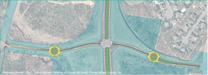
2017 Concept for a Clover Hill Road/Prince William Parkway “Bowtie” Intersection

Recently, the Prince William County Department of Transportation asked for our feedback on their proposed preliminary design for rebuilding the intersection of the Prince William Parkway (Route 234) and Clover Hill Road near Manassas as an “innovative” bowtie intersection, where all direct left turns are eliminated and instead accommodated via two roundabouts on the minor cross street.   Our reply is posted below.   We will track this upcoming project in the coming years as the design is refined for construction.


Thank you for soliciting Active Prince William’s input on how the redesigned intersection of Clover Hill Road at the Prince William Parkway can best serve people walking and bicycling.

Conventional On-Road Bike Lanes Are Appropriate for Clover Hill Road

Clover Hill Road provides an important low-traffic bicycling connection between the City of Manassas (and adjacent residential neighborhoods within the County) and Manassas Regional Airport and points west, including the Broad Run VRE station and the new Route 28 shared-use path that now extends though Bristow all the way to Nokesville.  On the southwest side of Route 234, Clover Hill Road provides critical bicycling access to a network of low-traffic, bicycling-friendly roads within and near Manassas Regional Airport, including Harry J Parrish Blvd. Wakeman Drive, Observation Drive, Piper Lane, Residency Road, Pennsylvania Avenue, Carolina Drive, and Gateway Blvd.

As such, Clover Hill Road is eminently useful for bicycle commuting to employment sites within and near the airport, to the Broad Run VRE station, and to points west in Bristow.  In addition, Clover Hill Road and the low-traffic roads within and around the airport are used extensively for recreational bicycling on evenings and weekends.

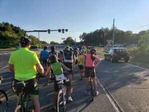
Bicyclists on Bull Run Bicycle’s Tuesday evening shop ride wait to cross Route 234 at Clover Hill Road. To avoid hazardous right-turning traffic on both sides of this intersection, the group waits for a green traffic signal in the left travel lane of Clover Hill Road.

Both City of Manassas roadways that connect to this segment of Clover Hill Road–i.e.. Clover Hill Road from Godwin Drive to Wellington Road and Godwin Drive from Clover Hill Road to Hastings Drive–already have conventional on-road bike lanes.  Thus, in addition to including sidewalks for pedestrians, the entire redesigned segment of Clover Hill Road should include conventional on-road bike lanes in both directions.

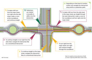
Note that VDOT’s website that describes bowtie intersections includes conventional on-road bike lanes on all four legs of that intersection (see the illustration copied below).

Since, as in the above illustration, the proposed design features dedicated right-turn-only lanes on Clover Hill Road at both approaches to the Prince William Parkway, it would be vital to install the bike lanes at both approaches to the Prince William Parkway between the straight-through travel lane on the left and the right-turn-only lane at the curb.

Within the roundabouts, the bike lanes–if any–should be on the far right and could be buffered or physically separated from roadway traffic.  Alternatively, especially if right-of-way is constrained at the roundabouts, the bike lanes could be discontinued within the roundabouts and bicyclists encouraged to navigate the roundabouts as either a driver centered within the travel lane or (using strategically placed curb ramps for access and egress) as a pedestrian using the sidewalk.

However, upon exiting each roundabout, right-turning motorists should be directed to yield to any bicycle traffic ahead and to carefully merge right across the continued bike lane to enter the emerging right-turn-only lane before reaching either the Parkway (along both southbound and northbound Clover Hill Road) or Godwin Drive (along northbound Clover Hill Road).

Please note that these same conflicts between right-turning motorists and straight-through bicyclists presently exist at the current Clover Hill Road/Route 234 Intersection in the absence of any bike lanes and that appropriate traffic engineering measures, involving pavement markings and signage, can optimize the safety of all road users.

Design This Intersection to Safely Accommodate the Future Shared-Use Path Along Route 234

Although this project won’t construct the long-planned missing shared-use path along Route 234, the design of this intersection should not preclude its future construction and should also ensure that pedestrians and bicyclists using that shared-use path can cross Clover Hill Road safely.  As a designated segment of the National Capital Trail Network, a continuous, high-quality shared-use path along Route 234 should be a priority for Prince William County.

Unobstructed right-of-way should be acquired and preserved as part of this project to accommodate the future Route 234 shared-use path, and the project design should ensure that the route and future design of this path would not be blocked or compromised by noise barriers, above-ground or buried utilities, or roadside signage, traffic signals, or street lighting.  Until the county decides whether this path will be constructed on the northeast or southwest side of Route 234, right-of-way should be reserved for the future shared-use path on both sides.

In addition, the intersection design should ensure that the future Route 234 Trail will have a safe, at-grade crossing of Clover Hill Road, presumably coordinated with the same traffic signal that regulates the Route 234 traffic.

Eliminate High-Speed Right-on-Red Turning Movements from Route 234 onto Clover Hill Road

Unlike VDOT’s model bowtie intersection illustrated above, the currently proposed intersection design incorporates two free-flowing, high-speed, right-turning movements, using pork-chop islands, for Route 234 traffic to enter Clover Hill Road.  We believe this currently proposed design feature would seriously endanger both 1) bicyclists and pedestrians crossing Route 234 at Clover Hill Road and 2) the users of the future Route 234 Trail crossing Clover Hill Road.

Vulnerable, non-motorized road and trail users who are crossing either roadway on a green traffic signal should not be endangered by high-speed traffic that is simultaneously turning right-on-red at near-freeway speeds at these pork-chop islands.  While a decision to completely ban all right-turn-on-red movements at this intersection might best be made by expert traffic engineers, we firmly believe that free-flowing right-on-red movements would be dangerous at this intersection and should not be promoted by design features such as pork-chop islands.

Instead, vehicle traffic entering Clover Hill Road from Route 234 should be encouraged to slow to the 25 MPH posted speed and carefully merge into the single travel lane approaching the roundabout, while bicyclists who have just crossed Route 234 on a green signal must merge into the bike lane at the right edge of the roadway.

Again, careful pavement marking and signing would help all road users safely negotiate these conflicts, whereas a design that promotes high-speed right-on-red vehicle traffic would endanger vulnerable road users.

Bicyclists and pedestrians crossing Route 234 at Clover Hill Road on a green traffic signal would primarily be endangered by motorists turning right-on-red from Route 234 at the far side of their crossing.  By contrast, users of the future Route 234 Trail crossing Clover Hill Road on a green traffic signal could encounter both motorists turning right-on-green from Route 234 as well as motorists turning right-on-red from Clover Hill Road.   All such right-turning movements would be safer if the design encourages motorists to slow or stop completely before entering a crosswalk and turning into the path of vulnerable road users.  Partial traffic signal phasing, such as leading pedestrian intervals, could also make these crossings safer.

Clover Hill Road is a local street posted for 25 MPH, and there is no compelling need to promote free-flowing right-turn-on-red vehicle movements onto Clover Hill Road.

The 2019 AADT for all connected local roadways (i.e., Clover Hill Road, Godwin Drive, and Harry J Parrish Blvd) ranges from 2100 to 4700, so Clover Hill Road only needs one travel lane per direction between intersections. The proposed design includes a grassy median along Clover Hill Road, but there’s no compelling need for a grassy median on a road posted for 25 MPH, and that grassy median is about a full-lane wide on the segment approaching Godwin Dr.

Active Prince William also supports the inclusion of a shared-use path along this entire segment of Clover Hill Road; however, such a path would not connect to any existing path along Clover Hill Road, Godwin Drive or Harry J. Parrish Blvd, and it appears that the long-planned path along the Route 234 Bypass won’t be built for the foreseeable future.  Thus, a shared-use path seems less essential, especially on the airport side of Route 234, provided that both sides of Clover Hill Road will have sidewalks and bike lanes.

If spatial or terrain constraints would otherwise preclude the addition of both on-road bike lanes and sidewalks along Clover Hill Road in both directions, consideration should be given to narrowing or eliminating the grassy medians.

Thank you for considering our input.

###

Our Comments on PWC’s Proposed Transit Alternatives Map

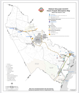
Prince William County’s Proposed “Future Transit Alternatives Map” Dated March 17, 2022

On April 15, 2022, Active Prince William submitted the following public comments on the draft “Future Transit Alternatives Map” that defines the public transportation element for the update to Prince William County’s Comprehensive Plan known as “Pathways to 2040”.


1) The Future Transit Alternatives Map needs to identify specific sites for proposed High-Capacity Transit stations that would exist by the year 2040.

The Metropolitan Washington Council of Governments needs to accept those sites on its map of High Capacity Transit Station Areas and to agree that they qualify as “Regional Activity Centers” (using the MWCOG definition of that term), so Prince William’s 2040 Comprehensive Plan is consistent with the Metropolitan Washington Planning Framework for 2030.

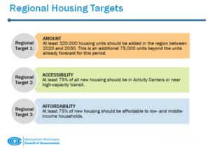
Unless specific station sites are identified, the Mobility Chapter will not be integrated with the Land Use and Housing Chapters.  Identifying the planned locations of future VRE and Metrorail stations is required for the Land Use Chapter (including Land Use Map) to specify where new Transit-Oriented Development (TOD) will be planned within walking distance of High-Capacity Transit Stations.  Identifying the planned locations of future VRE and Metrorail stations is required for the Housing Chapter to plan to meet regional housing targets set with MWCOG.

MWCOG’s Regional Housing Targets

2) The Future Transit Alternatives Map should clarify if all projects shown on the map are planned to be completed by 2040.   If some projects will have a longer time frame, then the projects planned to be completed by 2040 should be identified clearly or included on a separate map.  In particular, the proposed extensions of the Metrorail Orange Line and the VRE Manassas Line are redundant, and both are likely unnecessary with the advent of the I-66 Express Lanes.  The Future Transit Alternatives Map should clearly identify that the existing I-95 and imminent I-66 Express Lanes are “existing” High-Capacity Transitways.

Knowing what projects are expected to be built over the next 20 years is necessary so other Comprehensive Plan policies, action strategies, and projects can be budgeted and synchronized.  Maps showing planned roads and trails should also identify projects planned for completion by 2040, plus other aspirational projects using the same approach for transit projects.

3) The Mobility Chapter should include action strategies to acquire right-of-way for the proposed route of the Orange Line to Gainesville or that project should be removed from the map.  Unless located within the I-66 right of way, the right-of-way for the Orange Line extension may require going through Bull Run Regional Park, Manassas National Battlefield Park, and/or high-value commercial properties.  Fairfax County committed almost $60 million to preserve right-of-way along the I-66 corridor for extending Orange Line to Centerville during expansion to create Express Mobility Partners toll lanes, but Prince William preserved no right-of-way–suggesting a proposal for extending the Orange Line to Gainesville is more of a fantasy than an actual plan.

4) If the proposed route of the Orange Line to Gainesville remains on Future Transit Alternatives Map , then the Land Use Chapter should include plans for town centers with T-5 and T-6 Transect Zones at the station locations.

5) The Mobility Chapter should define the southern terminus of the proposed Blue/Yellow Line in eastern Prince William, and that terminus should subsequently be identified in the Visualize 2045, TransAction, and VTrans plans.

6) The Mobility Chapter should include action strategies to acquire right-of-way for the proposed route of the Blue/Yellow Line to Triangle or of the proposed BRT system.

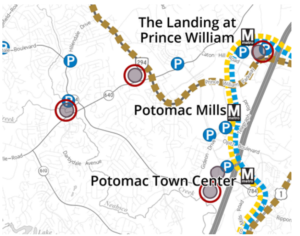
7) The proposed route of the Blue/Yellow Line to Triangle , or of the proposed BRT system, should be clarified so it will be clear what land parcels will be suitable for Transit-Oriented Development.  In particular, it should be clear if the large Potomac Mills site will have a High-Capacity Transit station at one edge, because portions of that property could end up more than one-half mile from a station.

8) The Quartz development at the intersection of Minnieville Road and Prince William Parkway, and the intersection of Dale Boulevard-Minnieville Road should not be designated as “MultiMobile Hubs” if those sites will not have a High-Capacity Transit station.  Bus stops with commuter lots technically might be “multimobile,” but should not be planned for the same level of development as sites with a High-Capacity Transit station.

Proposed “Future Transit Alternatives” for Eastern Prince William County

9) Plans for town centers with T-5 and T-6 Transect Zones should be included in the Land Use Map for all sites in eastern Prince William where a High-Capacity Transit station is planned.

10) Action strategies in the Mobility Chapter should identify how to obtain local, state, and Federal funding for extension of Metrorail to Prince William, creation of a Bus Rapid Transit system and shuttle/trolley systems, and development of infrastructure for the proposed commuter ferry.

11) The Land Use Map should identify where affordable housing is planned within walking distance of planned High-Capacity Transit stations, in order to meet the MWCOG targets.  Families are cost-burdened if housing costs exceed 30% of Area Median Income, but also cost-burdened if housing and transportation costs combined exceed 42% of Area Median Income.

12) The 2040 Comprehensive Plan should quantify the shortage of affordable housing units for families earning 30%, 50%, and 80% of Area Median Income now, and the projected shortage in 2030 and 2040.  The Land Use Map should identify where new affordable housing will be developed by 2030 and 2040 to eliminate the shortage of affordable housing in those three categories, and those locations for new affordable housing should be planned within walking distance of High-Capacity Transit stations.

13) More-detailed shuttle/trolley routes and boundaries of areas where service is planned should be identified on the Future Transit Alternatives Map.  The Mobility Chapter should include an action strategy to complete and update regularly origin and destination studies for proposed shuttle/trolley routes, in order to integrate the Mobility Chapter with other 2040 Comprehensive Plan chapters and with the Comprehensive Plans in the Cities of Manassas and Manassas Park. Shuttle/trolley routes should be structured to connect Activity Centers as defined by MWCOG and also nodes of existing/planned dense development as shown on the Land Use Map.

14) An action strategy should be included in the Mobility Chapter to identify the year when shuttle/trolley service will become operational, so rezonings and construction plans can be synchronized.

15) If “[s]pecific objectives include adapting to changing mobility trends, improving multi-modal options, increasing the use of public transit, increasing travel time reliability while concurrently striving to decrease the use of vehicle fuels that contribute to climate change,” then the Mobility Chapter needs to add Local and Express Bus Service maps showing areas to be served by bus service and the stages in which that service will be expanded over the next 20 years.  Upgrading local bus service to facilitate access to local jobs, schools, healthcare, retail, and other key destinations for less-advantaged households is at least as essential as extending commuter rail routes that carry white-collar workers out of Prince William. Upgrading low-cost local transit and upgrading bike/pedestrian access offers the greatest opportunity to invest in upgrading equity.  Fairfax Connector Transit Strategic Plan Update offers an understandable format that can be used to support comprehensive plan update effort

16) “High-Capacity Transit”, as identified on this map, should be adequately defined in terms of weekday boardings, peak-period headways, and service hours.  Bus service that operates for fewer than 16 hours on weekdays, has peak-period headways longer than 15 or 20 minutes, or experiences fewer than 500 daily boardings is merely ordinary transit service.

17) The “High-Capacity Transit” lines in the western part of the county, which lack connections to Downtown Manassas, the Manassas Park City Center, the Godwin Drive Technology Corridor, and Sudley Road/Route 234 Business, are missed opportunities.  Recommend coordinating with Omniride which represents the entire Greater Manassas area.

###

Will Prince William’s Road Expansions Bust Our Region’s Climate Goals?

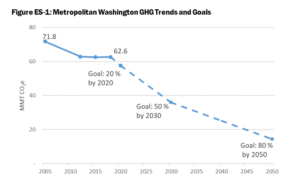
To lessen catastrophic climate change from the burning of fossil fuels, the Metropolitan Washington Council of Governments (MWCOG) has collectively pledged to substantially reduce our region’s emissions of greenhouse gases (GHG) from the level that existed in 2005–by 50% by 2030 and by 80% by 2050.

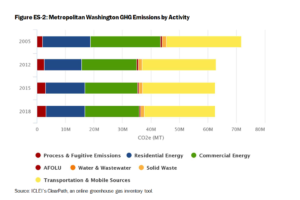
The major sources of our region’s greenhouse gas emissions.  Transportation (yellow bars) is now the largest single source of our greenhouse gas emissions, comprising at least 40% of the total.

Prince William County and all other localities in the Metropolitan Washington Council of Governments (MWCOG)–and the associated National Capital Region Transportation Planning Board (TPB)–have committed to reduce greenhouse gas emissions to 50% of the 2005 level by 2030.  In the County, the transportation sector–cars and trucks, primarily–is the largest source of greenhouse gas emissions.   By 2030, there will be more electric vehicles (and a somewhat cleaner electric grid), but most vehicles will still be powered by fossil fuels and emit carbon dioxide from tailpipes.

The County’s traditional business-as-usual transportation planning–expanding highways for drive-alone commutes–would sabotage efforts to meet the 2030 target.  In particular, the proposed Route 28 Bypass would not increase local jobs but would increase solo auto commutes and greenhouse gas emissions.  Spending well over $200 million in County tax revenue on the Route 28 Bypass would subsidize housing and jobs in other localities, while sabotaging efforts to meet our region’s 2030 greenhouse gas target to lessen our global climate crisis.

Instead of building the Route 28 Bypass, the eight members on the Board of County Supervisors (BOCS) could plan to meet our region’s 2030 climate target and invest the savings to upgrade local infrastructure to better access local jobs.  What makes the most sense to you?

Below is our recent email exchange with BOCS Chair (and TPB Member) Ann Wheeler.   Active Prince William sent similar messages to Neabsco District Supervisor Victor Angry, Manassas Vice Mayor Pamela Sebesky, and Manassas Park Mayor Jeanette Rishell who also serve on the National Capital Region Transportation Planning Board (TPB).


From: Active Prince William <[email protected]>
Sent: Thursday, March 31, 2022 6:46 PM
To: Wheeler, Ann <[email protected]>; Angry, Victor S. <[email protected]>
Cc: Belita, Paolo J. <[email protected]>; Canizales, Ricardo <[email protected]>
Subject: Metropolitan Washington 2030 Climate and Energy Action Plan

Dear Chair Wheeler and Supervisor Angry:

As members of the Transportation Planning Board (TPB), you have an especially important role in sustainability planning and advancing the Metropolitan Washington 2030 Climate and Energy Action Plan.  

Without action by TPB to adopt climate change mitigation goals and strategies, the region will not meet the 2030 and 2050 targets to reduce greenhouse gas emissions.  

Technological changes will not be sufficient; we need policy changes that reduce regional VMT and VMT per capita as well.  Fundamentally, the TPB must adopt targets and policies to reduce carbon emissions from the transportation sector.  The impact of new projects in Northern Virginia’s long-range multimodal transportation plan, TransAction, need to be quantified.  Otherwise, how can the 24 jurisdictions in MWCOG meet their 2030 and 2050 targets?

Similarly, each jurisdiction needs to “do the math” regarding planned land use changes.  Transit-Oriented Development can minimize the greenhouse gas emissions that will be increased by population growth.  Those increases must be offset in order to meet the 2030 and 2050 targets, and the impact of changes in land use planning must be quantified. Otherwise, how can the 24 jurisdictions in MWCOG meet their 2030 and 2050 targets?

As noted by the Coalition for Smarter Growth, the 2030 target to reduce greenhouse gas emissions to 50% below 2005 levels is essential for keeping our planet in the safety zone.  We cannot afford to ignore the cumulative impacts of emissions between now and 2030 and focus only on the 2050 target.


From: Wheeler, Ann <[email protected]>
Date: Mon, Apr 4, 2022 at 1:12 PM
Subject: RE: Metropolitan Washington 2030 Climate and Energy Action Plan
To: Active Prince William <active.princewilliam@gmail.com>, Angry, Victor S. <[email protected]>
Cc: Belita, Paolo J. <[email protected]>, Canizales, Ricardo <[email protected]>

Good afternoon-

Thank you for reaching out to our office.  I have attached the MWCOG plan for achieving GHG reductions.  As you can see on page 11 there will have to be various ways to address this issue and I know both MWCOG and TPB have discussed these at length.  Prince William County is a still growing outer jurisdiction, without Metro, which makes discussion of some of the items you brought up more difficult.  It is my belief that as an outer jurisdiction, with a current heavy reliance on automobiles, we should have a much, much greater focus on electrification of our County-owned fleet as well as encouragement of conversion to EVs through a robust charging infrastructure for our residents.  Even looking at the major activity or transit centers in the west where the housing growth will come from (Broad Run Station, the commuter lot on Route  29 and the commuter lot at Groveton) it will be difficult to get very high density around these three locations for various reasons.   I believe one of the strongest ways to ultimately reduce vehicle miles traveled is to expand our commercial base in Prince William County so people don’t have to commute to their job locations and that is what I am focusing on.  I am sure you will agree that ultimately this is a goal everyone can get behind.

Thank you for you comments as we continue evaluating our land-use and mobility plans to assure our future for the next twenty years.

In service,

Ann Wheeler


From: Active Prince William <active.princewilliam@gmail.com>
Date: Mon, Apr 4, 2022 at 6:31 PM
Subject: Re: Metropolitan Washington 2030 Climate and Energy Action Plan
To: Wheeler, Ann <[email protected]>
Cc: Angry, Victor S. <[email protected]>, Belita, Paolo J. <[email protected]>, Canizales, Ricardo <[email protected]><

Chair Wheeler,

Thank you for your response to our message regarding the need to reduce greenhouse gas emissions from the transportation sector.  We certainly agree that “one of the strongest ways to ultimately reduce vehicle miles traveled is to expand our commercial base in Prince William County so people don’t have to commute to their job locations.”

That perspective should shape the county’s investments in new transportation infrastructure.  We should prioritize building new capacity that maximizes mobility while minimizing Vehicle Miles Traveled.  The 2040 Comprehensive Plan should focus on creating walkable communities to accommodate the expanding population.  The County priority for new mobility infrastructure should be expansion of local Omniride and shuttle/trolley services, plus bike/pedestrian connections that anticipate increasing use of e-bikes.

To expand our commercial base and increase local jobs, we should stop funding construction of new lane miles designed for Prince William commuters to leave the county–and for auto commuters who live to our west and south to commute through Prince William County–for jobs in other jurisdictions.  In particular, the county’s $200 million subsidy for the Route 28 Bypass is inconsistent with a priority to expand our commercial base in Prince William County so people don’t have to commute to their job locations.

That project, especially when the destruction of houses in an Equity Emphasis Area is viewed through an equity lens, should be cancelled.  The funding earmarked to repay the $200 million in county bonds, should be re-purposed in a joint venture with the school system to fund the Sustainability Action Plan that the Sustainability Commission will complete in the next year.

###

« Older posts Newer posts »